Category:Contributiehuisje
Jump to navigation
Jump to search
| Object location | | View all coordinates using: OpenStreetMap |
|---|
 | |||||
| Upload media | |||||
| Instance of | |||||
|---|---|---|---|---|---|
| Location | Kollumerpomp, Noardeast-Fryslân, Friesland, Netherlands | ||||
| Street address |
| ||||
| Located on street |
| ||||
| Heritage designation |
| ||||
 | |||||
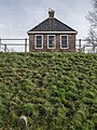
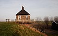
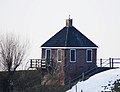
Nederlands: Het contributiehuisje in Kollumerpomp werd in 1828 gebouwd door het waterschap "Contributie Zeedijken Kollumerland en Nieuw Kruisland" als vergaderruimte. Het werd tevens gebruikt als stormwachterhuis: als er een overstroming dreigde, konden de dijkwachter en mensen van het waterschap vanuit de ramen kijken hoe het water steeg en zo nodig actie ondernemen. Meer informatie: Contributiehuisje Kollumerpomp: ‘Uniek huisje op een unieke plek’
|
This is a category about rijksmonument number 353642
|
| Address |
|
Media in category "Contributiehuisje"
The following 12 files are in this category, out of 12 total.
-
 Contributiehuisje, Kollumerpomp 1.jpg 1,732 × 2,307; 2.84 MB
-
 Contributiehuisje, Kollumerpomp 2.jpg 2,308 × 1,733; 2.04 MB
-
 Contributiehuisje, Westernieuwkruisland 17, Kollumerpomp.JPG 3,694 × 2,312; 1.42 MB
-
 Contributiehuisje.jpg 2,741 × 2,103; 541 KB
-
 Exterieur overzicht - Kollumerpomp (De Pomp) - 20327653 - RCE.jpg 1,195 × 1,200; 397 KB
-
 Overzicht - Kollumerpomp - 20126686 - RCE.jpg 1,197 × 1,200; 344 KB
-
 Overzicht - Kollumerpomp - 20126687 - RCE.jpg 1,195 × 1,200; 375 KB
-
 Overzicht - Kollumerpomp - 20126688 - RCE.jpg 1,192 × 1,200; 412 KB
-
 Overzicht - Kollumerpomp - 20126689 - RCE.jpg 1,200 × 1,190; 397 KB
-
 Overzicht - Kollumerpomp - 20126690 - RCE.jpg 1,200 × 1,192; 328 KB
-
 Overzicht - Kollumerpomp - 20126691 - RCE.jpg 1,200 × 1,200; 323 KB
-
 Overzicht contributiehuisje tevens stormwachterhuis - Kollumerpomp - 20345575 - RCE.jpg 1,183 × 1,200; 407 KB


_-_20327653_-_RCE.jpg)


