Category:Covered Bridge, Spanning South Fork of Licking River, Cynthiana, Harrison County, KY HABS
Jump to navigation
Jump to search
former covered bridge spanning the South Fork of Licking River, Cynthiana, Harrison County, Kentucky, USA 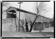 | |||||
| Upload media | |||||
| Instance of | |||||
|---|---|---|---|---|---|
| Location | Cynthiana, Harrison County, Kentucky | ||||
| Inception |
| ||||
| Dissolved, abolished or demolished date |
| ||||
 | |||||
Media in category "Covered Bridge, Spanning South Fork of Licking River, Cynthiana, Harrison County, KY HABS"
The following 2 files are in this category, out of 2 total.


Categories:
- Cynthiana, Kentucky
- 1934 in Kentucky
- Historic American Buildings Survey of Kentucky
- Black and white photographs of bridges in Kentucky
- Bridges over rivers in Kentucky
- Arch bridges in Kentucky
- Covered bridges in Kentucky
- Through truss bridges in Kentucky
- 1800s bridges in Kentucky
- Built in Kentucky in 1808
- Bridges in the United States completed in 1808
- Destroyed bridges in Kentucky
- Bridges in the United States less than 0.1 kilometers