Category:Curvature of the Earth
Zur Navigation springen
Zur Suche springen
mathematisch möglichst einfach definierbare Annäherung an die Form der Erde | |||||
| Medium hochladen | |||||
| Unterklasse von | |||||
|---|---|---|---|---|---|
| Besteht aus |
| ||||
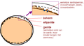
| Eventuell gleichwertig | Geoid | ||||
| |||||
Unterkategorien
Es werden 3 von insgesamt 3 Unterkategorien in dieser Kategorie angezeigt:
In Klammern die Anzahl der enthaltenen Kategorien (K), Seiten (S), Dateien (D)
C
- Curvature of the horizon (45 D)
M
- Meteotek 08 (18 D)
Medien in der Kategorie „Curvature of the Earth“
Folgende 128 Dateien sind in dieser Kategorie, von 128 insgesamt.
-
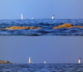
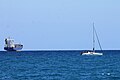
 27. Curvature of the earth—approaching ship (22759263611).jpg 1.708 × 1.658; 227 KB
-
 Barco ocultándose en el horizonte (Biarritz) 1.jpg 4.896 × 2.752; 5,1 MB
-
 Barco ocultándose en el horizonte (Biarritz) 1.png 738 × 2.080; 2,38 MB
-
 Barco ocultándose en el horizonte (Biarritz) 2.jpg 4.896 × 2.752; 5,08 MB
-
 Barco ocultándose en el horizonte (Biarritz) 2.png 1.477 × 832; 2,02 MB
-
 Barco ocultándose en el horizonte (Biarritz) 3.jpg 4.896 × 2.752; 4,91 MB
-
 Barco ocultándose en el horizonte (Biarritz) 4.jpg 4.896 × 2.752; 4,92 MB
-
 Barco ocultándose en el horizonte (Biarritz) 5.jpg 4.896 × 2.752; 4,87 MB
-
 Barco ocultándose en el horizonte (Biarritz) 6.jpg 4.896 × 2.752; 6,52 MB
-
 Barco ocultándose en el horizonte (Biarritz) 7.jpg 4.896 × 2.752; 4,64 MB
-
 Barco ocultándose en el horizonte (Biarritz) 8.jpg 4.896 × 2.752; 4,89 MB
-
 Barco ocultándose en el horizonte (Biarritz).gif 614 × 345; 426 KB
-
 Barco ocultándose en el horizonte (Getaria) 1.jpg 4.896 × 2.752; 4,76 MB
-
 Barco ocultándose en el horizonte (Getaria) 1.png 3.938 × 2.216; 8,68 MB
-
 Barco ocultándose en el horizonte (Getaria) 2.jpg 4.896 × 2.752; 4,69 MB
-
 Barco ocultándose en el horizonte (Getaria) 2.png 1.969 × 4.432; 8,26 MB
-
 Barco ocultándose en el horizonte (Getaria) 3.jpg 4.896 × 2.752; 4,52 MB
-
 Barco ocultándose en el horizonte (Getaria) 4.jpg 4.896 × 2.752; 5,06 MB
-
 Barco ocultándose en el horizonte (Getaria).gif 853 × 480; 2,06 MB
-
 Barco ocultándose en playa de Biarritz (estabilizado).gif 450 × 253; 6,4 MB
-
Barco ocultándose en playa de Biarritz (estabilizado).webm 14 s, 1.920 × 1.080; 2,78 MB
-
Barco ocultándose en playa de Biarritz.webm 34 s, 1.920 × 1.080; 7,01 MB
-
 Barcos Horizonte.gif 1.200 × 508; 3,9 MB
-
 Barcos Horizonte.jpg 1.234 × 879; 86 KB
-
 Barcos Horizonte.png 1.801 × 1.575; 3,17 MB
-
Barcos Horizonte.webm 1 min 11 s, 1.920 × 1.080; 19,82 MB
-
 Calculating How Much of a Distant Object is Visible Above the Horizon.jpg 1.922 × 1.080; 296 KB
-
 Calculation for How Much of a Distant Object is Visible to Observer.jpg 2.080 × 1.026; 350 KB
-
 Canigou hidden by the curvature of Earth GIF.gif 1.200 × 562; 4,13 MB
-
 Canigou hidden by the curvature of Earth.jpg 1.272 × 1.340; 1,39 MB
-
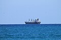
 Cargo ship 2.png 2.198 × 865; 159 KB
-
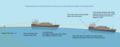 Cargo ship 3.png 2.198 × 865; 148 KB
-
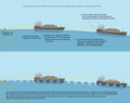 Cargo ship 4.png 2.196 × 1.730; 313 KB
-
 Cargo ship 5.png 2.196 × 1.730; 309 KB
-
 Cargo ship 6.png 2.196 × 1.730; 270 KB
-
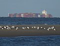
 Catalina Island beyond the freighters (51030012367).jpg 2.248 × 1.314; 602 KB
-
 CD002-Sphéricité de la Terre.jpg 1.245 × 350; 27 KB
-

-
 Comparison of Chicago being hidden by Earth's curvature.gif 800 × 320; 1,93 MB
-
 Comparison of Turning Torso, Malmö, being hidden by Earth's curvature.jpg 2.232 × 2.183; 3,26 MB
-
 Comparison of Volcan Tunupa (Oruro), Salar de Uyuni, being hidden by Earth's curvature 2.jpg 3.840 × 3.239; 10,78 MB
-

-
 Containerfrachter hinter dem Horizont.jpg 3.000 × 2.306; 2,67 MB
-
 Courbature.svg 744 × 1.052; 6 KB
-
 Courbature2.svg 400 × 400; 7 KB
-
 Curvatura 2.gif 2.809 × 1.580; 36,83 MB
-
 Curvatura de la Tierra en Salou 2.jpg 3.840 × 2.160; 2,53 MB
-
 Curvatura de la Tierra en Salou 3.jpg 3.840 × 2.160; 3,2 MB
-
 Curvatura de la Tierra en Salou 4.jpg 3.840 × 2.160; 2,82 MB
-
 Curvatura de la Tierra en Salou.jpg 3.840 × 2.160; 3,05 MB
-
 Curvatura.gif 1.000 × 1.000; 4,68 MB
-
 Curvature of the Earth in Benicasim 1.jpg 3.840 × 2.160; 3,12 MB
-
 Curvature of the Earth in Benicasim 2.jpg 3.840 × 2.160; 3,66 MB
-
 Curvature of the Earth in Benicasim.jpg 3.840 × 2.160; 3,49 MB
-
 Curvature of the Earth.png 2.304 × 1.296; 1,79 MB
-
 De geoïde.PNG 580 × 319; 16 KB
-
 DX-HF.PNG 749 × 746; 341 KB
-
 Earth Curvature in Benicàssim 2.jpg 4.749 × 2.669; 1,85 MB
-
 Earth Curvature in Benicàssim 3.jpg 4.749 × 2.669; 1,97 MB
-
 Earth Curvature in Benicàssim 4.jpg 3.840 × 2.160; 4,55 MB
-
 Earth Curvature in Benicàssim.jpg 3.725 × 2.095; 1.006 KB
-
 Earth Curvature near Kiel (Germany).jpg 3.000 × 2.000; 822 KB
-
 Earth exp.png 294 × 304; 6 KB
-
 Earth geo.png 268 × 240; 19 KB
-
 Earth oblateness to scale.svg 512 × 512; 2 KB
-
 Earth's curvature from 37,000 ft + ISS.jpg 1.269 × 623; 102 KB
-
 Earth2014shape SouthAmerica small.jpg 1.500 × 1.362; 403 KB
-
 Erdkruemmung.png 1.872 × 308; 5 KB
-
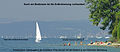 Erdkrümmung Bodensee IMGP3042.jpg 2.761 × 1.205; 976 KB
-
Erdkrümmung erklärt.webm 37 s, 1.920 × 1.080; 29,83 MB
-
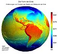 Form der Erde.jpg 1.518 × 1.410; 481 KB
-
 Gekrümmte Fläche (Globus).jpg 600 × 359; 241 KB
-
 Geoid Bronze Barnstar.png 2.150 × 2.048; 881 KB
-
 Geoid undulation 10k scale.jpg 1.200 × 1.200; 147 KB
-
 Geoid undulation to scale.jpg 1.200 × 1.200; 109 KB
-
 Hauteur cachee 50km.png 941 × 524; 47 KB
-
 Height of Distant Island visible above Horizon from Observer on Boat.jpg 2.582 × 1.318; 556 KB
-
 Horizon, Valencia (Spain).JPG 2.592 × 1.944; 1,91 MB
-
 Horizontformel (Wangerooge).png 1.733 × 1.299; 2,47 MB
-
 Illustration of principal curvatures on an oblate spheroid (ellipsoid of revolution).png 1.280 × 720; 42,68 MB
-
Illustration of principal curvatures on an oblate spheroid (ellipsoid of revolution).webm 3 min 0 s, 1.280 × 720; 55,39 MB
-
 Image 398 of M. Blundeuile his exercises.png 601 × 243; 223 KB
-
-
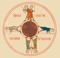
 La rotondité de la Terre, Image du monde (cropped).jpg 1.245 × 931; 127 KB
-
 La rotondité de la Terre, Image du monde.jpg 2.096 × 3.100; 655 KB
-
 La Terre est ronde, Image du Monde, Gossuin de Metz.png 842 × 818; 460 KB
-
 Lake Pontchartrain Causeway From Three Lakeway Center.png 1.983 × 1.313; 2,92 MB
-
 Lake Pontchatrain Causeway Southbound.jpg 4.000 × 3.000; 4,87 MB
-
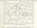
 Maury Geography 008C horizon.jpg 990 × 394; 50 KB
-

-
 Meteor Burst SNOTEL.jpg 590 × 400; 26 KB
-
 Mount Fuji hidden by Earth's curvature (2).gif 1.200 × 600; 8,95 MB
-
 Mount Fuji hidden by Earth's curvature (2).jpg 3.997 × 5.977; 1,26 MB
-
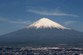 Mount Fuji hidden by Earth's curvature.gif 1.200 × 800; 7,09 MB
-
 Mount Fuji hidden by Earth's curvature.jpg 3.975 × 3.975; 704 KB
-
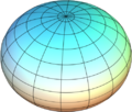 OblateSpheroid.PNG 503 × 426; 173 KB
-
 Observación de la Isla de Ons (1).jpg 4.752 × 2.673; 999 KB
-
 Observación de la Isla de Ons.jpg 2.673 × 2.673; 1,34 MB
-
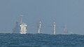
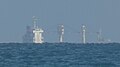
 Offshore windpark Thorntonbank.jpg 1.800 × 1.350; 364 KB
-
 Playa de Alicante 2.jpg 4.272 × 2.848; 3,04 MB
-
 Playa de Alicante 4.jpg 4.272 × 2.848; 3,85 MB
-
 Propagation ondes moyenne.PNG 923 × 522; 434 KB
-
 Propagation VHF.PNG 1.275 × 549; 941 KB
-
 Puissance d'un point.png 1.510 × 1.083; 31 KB
-
 Sagunt curvature of the Earth.jpg 897 × 911; 114 KB
-
 Santa Catalina Island, California 1 2022-06-06.jpeg 4.032 × 3.024; 8,62 MB
-
 Shiphorp.jpg 405 × 237; 15 KB
-
 Sichtweite 1.png 1.000 × 940; 28 KB
-
 Sichtweite 2.png 1.000 × 940; 27 KB
-
 Sichtweite.png 400 × 400; 3 KB
-
 Sichtweite2.png 400 × 400; 5 KB
-
 Sunset Half Dome timelapse.gif 600 × 400; 1,42 MB
-
 Tabarca desde Santa Pola (Comparacion).gif 1.200 × 716; 8,54 MB
-
 Tabarca y Torrelamata desde Santa Pola (Comparacion).gif 1.200 × 716; 52,3 MB
-
 Terre plate ou ronde?.png 2.125 × 794; 70 KB
-
 Torrelamata desde Santa Pola (Comparacion) 2.gif 1.200 × 716; 18,79 MB
-
 Torrelamata desde Santa Pola (Comparacion) 3.gif 1.200 × 716; 10,58 MB
-
 Torrelamata desde Santa Pola (Comparacion).png 1.365 × 1.024; 2,48 MB
-
 Turning Torso hidden by Earth's curvature.jpg 1.353 × 1.015; 168 KB
-
 Velero ocultándose en el horizonte (Getaria).png 1.626 × 915; 1.011 KB
-
Velero ocultándose en el horizonte en Getaria (video) 1.webm 36 s, 1.920 × 1.080; 9,64 MB
-
Velero ocultándose en el horizonte en Getaria (video) 2.webm 12 s, 1.920 × 1.080; 2,6 MB
-
 VHF propagation.png 2.229 × 1.110; 250 KB
-
 Visibcurp.png 504 × 309; 44 KB
-
 Visibility 1.png 1.000 × 940; 26 KB
-
 Visibility 2.png 1.000 × 940; 25 KB
-
 БСЭ1. Маяк 2.jpg 308 × 82; 16 KB
-
 سفينة تختفي خلف الأفق بسبب تحدب الأرض.gif 1.920 × 1.080; 13,68 MB
.jpg)
_1.jpg)
_2.jpg)
_2.png)
_3.jpg)
_4.jpg)
_5.jpg)
_6.jpg)
_7.jpg)
_8.jpg)
.gif)
_1.jpg)
_1.png)
_2.jpg)
_2.png)
_3.jpg)
_4.jpg)
.gif)
.gif)


.jpg)


,_Salar_de_Uyuni,_being_hidden_by_Earth%27s_curvature_2.jpg)


.jpg)


.jpg)


.JPG)
.png)
.png)
%27_(11291523126).jpg)
.jpg)


.gif)
.jpg)


.jpg)


.gif)
.gif)
_2.gif)
_3.gif)
.png)

.png)


_1.png)
,_Salar_de_Uyuni,_being_hidden_by_Earth%27s_curvature.png)