Category:Dee Estuary
Jump to navigation
Jump to search
| Object location | | View all coordinates using: OpenStreetMap |
|---|
estuary  | |||||
| Upload media | |||||
| Instance of | |||||
|---|---|---|---|---|---|
| Location |
| ||||
| Heritage designation | |||||
| Origin of the watercourse | |||||
| Tributary | |||||
 | |||||

The Dee Estuary is is a large estuary by means of which the River Dee flows into Liverpool Bay.
Subcategories
This category has the following 5 subcategories, out of 5 total.
Media in category "Dee Estuary"
The following 96 files are in this category, out of 96 total.
-
 A boat on marshland near Flint castle - geograph.org.uk - 1739849.jpg 640 × 480; 113 KB
-
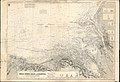 Admiralty Chart No 1170B Great Ormes Head to Liverpool, Published 1886, New Edition 1910.jpg 15,849 × 10,855; 50.05 MB
-
 Benkid77 Small boats, River Dee 200709.JPG 2,240 × 1,680; 872 KB
-
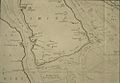 Bodleian Libraries, A New Exact Survey of the River Dee or ChesterWater.jpg 1,000 × 693; 89 KB
-
 Brynford Hall Farm - geograph.org.uk - 1142377.jpg 640 × 498; 105 KB
-
 Castle Road railway bridge - geograph.org.uk - 1739605.jpg 640 × 480; 96 KB
-
 Cliff edge and the Dee estuary - geograph.org.uk - 1737027.jpg 800 × 530; 183 KB
-
 Cornist Park, Flint - geograph.org.uk - 1221453.jpg 640 × 479; 95 KB
-
 Dee Estuary - geograph.org.uk - 1144718.jpg 640 × 480; 72 KB
-
 Dee Estuary - geograph.org.uk - 217891.jpg 640 × 480; 55 KB
-
 Dee estuary by Hilbre Point, Hoylake - geograph.org.uk - 237250.jpg 640 × 480; 71 KB
-
 Dee estuary east of Hilbre Island - geograph.org.uk - 237253.jpg 640 × 480; 101 KB
-
 Dee Estuary from Lime Wharf - geograph.org.uk - 218687.jpg 640 × 480; 100 KB
-
 Dee estuary wildlife cruise - geograph.org.uk - 220465.jpg 640 × 480; 53 KB
-
 Dee Estuary.JPG 2,203 × 1,305; 520 KB
-
 Dee estuary.jpg 640 × 480; 122 KB
-
 Dee Lane, West Kirby 2.JPG 3,648 × 2,736; 3.57 MB
-
 Deeside and Dee Estuary.jpg 2,395 × 3,193; 1.78 MB
-
 Footpath along the Dee estuary - geograph.org.uk - 1144721.jpg 640 × 480; 44 KB
-
 Grassland - geograph.org.uk - 203612.jpg 640 × 479; 96 KB
-
-
 Halkyn farmland - geograph.org.uk - 33766.jpg 512 × 384; 29 KB
-
 Hilbre Island in the Dee estuary, West Kirby, Wirral, Merseyside - panoramio (27).jpg 2,048 × 1,361; 676 KB
-
Illegal cockling results in vehicles seized and crushed.webm 15 s, 640 × 360; 951 KB
-
 Leaving Little Eye, Dee Estuary - geograph.org.uk - 1500788.jpg 640 × 424; 89 KB
-
 Looking across the River Dee from West Kirby - DSCF1843.JPG 4,000 × 3,000; 2.84 MB
-
 Looking towards the Moel-y-Parc transmitter from West Kirby - DSCF1842.JPG 4,000 × 3,000; 2.77 MB
-
 Looking towards the Moel-y-Parc transmitter from West Kirby - DSCF1848.JPG 4,000 × 3,000; 2.79 MB
-
 Looking towards the Point of Ayr lighthouse, Talacre from West Kirby - DSCF1856.JPG 4,000 × 3,000; 2.84 MB
-
 Low tide on the Dee estuary - geograph.org.uk - 709252.jpg 640 × 480; 69 KB
-
 Low Water in the Dee estuary - geograph.org.uk - 2268969.jpg 1,200 × 803; 228 KB
-
 Mast on Hilbre Island - geograph.org.uk - 1399460.jpg 480 × 640; 76 KB
-
 Mud Flats on the Dee Estuary from Mostyn Quay - geograph.org.uk - 1772378.jpg 3,504 × 2,336; 2.08 MB
-
 Oystercatchers - geograph.org.uk - 1144739.jpg 640 × 480; 44 KB
-
 Part of Flint- Fflint Castle - geograph.org.uk - 286330.jpg 640 × 480; 37 KB
-
 River Dee Estuary - geograph.org.uk - 640162.jpg 640 × 420; 32 KB
-
 Saltmarshes on the Dee Estuary - geograph.org.uk - 99027.jpg 640 × 480; 62 KB
-
 Sand Banks in the Dee Estuary from Mostyn Quay - geograph.org.uk - 1772390.jpg 3,504 × 2,336; 3.05 MB
-
 Sandbank marker buoy - geograph.org.uk - 2269042.jpg 1,200 × 797; 232 KB
-

-
 Sunset across the Dee Estuary, West Kirby (geograph 2964581).jpg 1,024 × 683; 77 KB
-
 The birds of the British Isles and their eggs (1920) (14563285927).jpg 2,652 × 1,728; 1.07 MB
-
 The Boat House 1 240709.JPG 3,648 × 2,736; 3.64 MB
-

-
 The Dee estuary and the Welsh coast - geograph.org.uk - 1240414.jpg 640 × 480; 124 KB
-
 The Dee estuary and West Kirby - geograph.org.uk - 1240476.jpg 640 × 480; 120 KB
-
 The Dee Estuary from Little Eye - geograph.org.uk - 1237349.jpg 640 × 424; 65 KB
-
 The Dee estuary towards Point of Ayr - geograph.org.uk - 1240428.jpg 640 × 480; 125 KB
-
 The north-east tower of Flint castle - geograph.org.uk - 1739836.jpg 640 × 480; 83 KB
-
 View across the Dee Estuary - panoramio.jpg 800 × 533; 67 KB
-
 View across the Dee from Thurstaston - Heswall path.jpg 5,163 × 3,442; 8.84 MB
-
 West Bar marker buoy - geograph.org.uk - 2269036.jpg 1,200 × 800; 256 KB
-
 West Bar marker buoy - geograph.org.uk - 2269039.jpg 1,200 × 800; 264 KB
-
 West Kirby, UK - panoramio (2).jpg 3,264 × 4,912; 837 KB
-
 Wheat fields and Dee estuary - geograph.org.uk - 30453.jpg 512 × 384; 34 KB
-
 Wirral, UK - panoramio (10).jpg 8,192 × 1,856; 2.78 MB
-
 Wirral, UK - panoramio (11).jpg 4,912 × 3,264; 3.09 MB
-
 Wirral, UK - panoramio (12).jpg 4,912 × 3,264; 4.22 MB
-
 Wirral, UK - panoramio (13).jpg 4,912 × 3,264; 4.06 MB
-
 Wirral, UK - panoramio (14).jpg 4,912 × 3,264; 3.94 MB
-
 Wirral, UK - panoramio (16).jpg 4,912 × 3,264; 5.41 MB
-
 Wirral, UK - panoramio (17).jpg 4,912 × 3,264; 5.03 MB
-
 Wirral, UK - panoramio (3).jpg 4,912 × 3,264; 4.03 MB
-
 Wirral, UK - panoramio (4).jpg 4,912 × 3,264; 3.34 MB
-
 Wirral, UK - panoramio (5).jpg 4,912 × 3,264; 4.22 MB
-
 Wirral, UK - panoramio (6).jpg 4,912 × 3,264; 3.53 MB
-
 Wirral, UK - panoramio (7).jpg 4,912 × 3,264; 4.69 MB
-
 Wirral, UK - panoramio (8).jpg 4,912 × 3,264; 3.84 MB
-
 Wirral, UK - panoramio (9).jpg 4,912 × 3,264; 3.59 MB
-
 A Harvested Field - geograph.org.uk - 325965.jpg 640 × 480; 205 KB
-
 Approach to Chwitffordd - geograph.org.uk - 34144.jpg 512 × 384; 27 KB
-
 Dee estuary - below the sewage outlet - geograph.org.uk - 709288.jpg 640 × 480; 103 KB
-
 Dee estuary - crumbling embankment - geograph.org.uk - 709246.jpg 640 × 480; 93 KB
-
 Dee Estuary from Pentre Halkyn - geograph.org.uk - 101381.jpg 640 × 480; 46 KB
-
 Embankment, Dee Estuary - geograph.org.uk - 668885.jpg 480 × 640; 48 KB
-
 Erosion in action - geograph.org.uk - 709249.jpg 640 × 480; 157 KB
-

-
 Fields near Holywell - geograph.org.uk - 285093.jpg 640 × 480; 58 KB
-
 Golch Farm - geograph.org.uk - 55828.jpg 640 × 299; 33 KB
-
 Hillside near Holywell - geograph.org.uk - 668873.jpg 640 × 480; 40 KB
-
 Isglan Road - geograph.org.uk - 668879.jpg 480 × 640; 102 KB
-
 Kelsterton Lane - geograph.org.uk - 217838.jpg 640 × 480; 79 KB
-
 Marker Posts at the Point on Flint Marsh - geograph.org.uk - 325854.jpg 640 × 480; 178 KB
-
 New embankment, Dee estuary - geograph.org.uk - 669013.jpg 640 × 480; 75 KB
-
 Old sea defence on Dee estuary - geograph.org.uk - 709282.jpg 640 × 480; 110 KB
-
 On Dee estuary - old man-made pier - geograph.org.uk - 709278.jpg 640 × 480; 69 KB
-

-
 Pastureland near Bagillt, Flintshire - geograph.org.uk - 198038.jpg 640 × 480; 98 KB
-
 Pen-y-Maes - geograph.org.uk - 97410.jpg 640 × 480; 51 KB
-
 Stranded boat - geograph.org.uk - 203596.jpg 640 × 479; 75 KB
-
 The Edge of Flint Marsh - geograph.org.uk - 325995.jpg 640 × 480; 183 KB
-
 The Marshes - geograph.org.uk - 669014.jpg 480 × 640; 53 KB
-
 The Moor - geograph.org.uk - 217843.jpg 640 × 480; 80 KB
-
 The Point on Flint Marsh - geograph.org.uk - 325539.jpg 640 × 480; 167 KB
-
 The River Dee - geograph.org.uk - 669015.jpg 640 × 480; 60 KB
-
 The view from Ffordd Isglan - geograph.org.uk - 218913.jpg 640 × 480; 97 KB


.jpg)


.jpg)
_(14563285927).jpg)


.jpg)

.jpg)
.jpg)
.jpg)
.jpg)
.jpg)
.jpg)
.jpg)
.jpg)
.jpg)
.jpg)
.jpg)
.jpg)
.jpg)


.jpg)
Categories:
- Estuaries of England
- Estuaries of Wales
- Ramsar sites in England
- Ramsar sites in Wales
- River Dee, England
- River Dee, Wales
- Glacial erosion in the United Kingdom
- Pleistocene glacial deposits in the United Kingdom
- Coal Measures Supergroup
- Carboniferous mudstone in the United Kingdom
- Triassic sandstone in the United Kingdom
- Flintshire Coalfield