Category:Denkmalzone Raiffeisenstraße (Ruppertsberg)
Jump to navigation
Jump to search
| Object location | | View all coordinates using: OpenStreetMap |
|---|

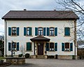
Raiffeisenstraße 1, 3: Catholic parsonage
- No. 1 former vicarage, one-and-a-half-storey plaster building, late Gothic and Renaissance motifs, identified by 1602
- No. 3 two-and-a-half-storey plaster building, around 1850, Post-Baroque outbuilding identified by 1806, over older remains, barn with two gateways, one identified :by 1589, another residential building, one-and-a-half-storey, and barn, both around 1850, garden wall 16th to 19th century.
Media in category "Denkmalzone Raiffeisenstraße (Ruppertsberg)"
The following 8 files are in this category, out of 8 total.
-
 027 2015 03 05 Kulturdenkmaeler Ruppertsberg.jpg 2,493 × 2,006; 3.99 MB
-
 028 2015 03 15 Kulturdenkmaeler Ruppertsberg.jpg 2,303 × 2,170; 3.71 MB
-
 029 2015 03 15 Kulturdenkmaeler Ruppertsberg.jpg 2,706 × 1,848; 4.57 MB
-
 Ruppertsberg 01.JPG 1,600 × 1,200; 951 KB
-
 Ruppertsberg 02.JPG 1,600 × 1,200; 1.03 MB
-
 Ruppertsberg 03.JPG 1,600 × 1,200; 1,012 KB
-
 Schloss - panoramio (37).jpg 1,244 × 1,200; 312 KB
-
 Schloss - panoramio (38).jpg 1,087 × 1,112; 345 KB


.jpg)
.jpg)