Category:Din Lligwy
Zur Navigation springen
Zur Suche springen

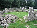
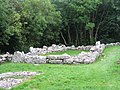
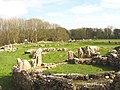
English: Din Lligwy (or Din Llugwy) hut circle is an ancient village site near the east coast of Anglesey, close to the village of Moelfre.
archäologische Stätte im Vereinigten Königreich  _nr_Moelfre,_Ynys_Mon,_Wales_05.png) | |||||
| Medium hochladen | |||||
| Ist ein(e) | |||||
|---|---|---|---|---|---|
| Ort | Moelfre, Isle of Anglesey, Wales | ||||
| Eigentümer/Besitzer | |||||
| Betreiber | |||||
| Betreut durch | |||||
| Schutzkategorie | |||||
| offizielle Website | |||||
 | |||||
Unterkategorien
Diese Kategorie enthält folgende Unterkategorie:
In Klammern die Anzahl der enthaltenen Kategorien (K), Seiten (S), Dateien (D)
A
- Aerial images of Din Lligwy (32 D)
Medien in der Kategorie „Din Lligwy“
Folgende 39 Dateien sind in dieser Kategorie, von 39 insgesamt.
-
 A round house at Din Lligwy - geograph.org.uk - 954037.jpg 640 × 480; 235 KB
-
 A square building at Din Lligwy - geograph.org.uk - 953999.jpg 640 × 480; 236 KB
-
 A view across Lligwy Bay from Din Lligwy - geograph.org.uk - 955008.jpg 640 × 480; 171 KB
-
 Ancient church at Din Lligwy - panoramio.jpg 3.642 × 1.645; 3,63 MB
-
 Bales in a field near Din Lligwy - geograph.org.uk - 952746.jpg 640 × 480; 196 KB
-
 Din Lligwy - geograph.org.uk - 218.jpg 640 × 480; 84 KB
-
 Din Lligwy and Plas Lligwy - geograph.org.uk - 954723.jpg 640 × 480; 198 KB
-

-
 Din Lligwy stone hut, Anglesey.JPG 1.500 × 1.000; 922 KB
-
 Din Lligwy workshop - geograph.org.uk - 952835.jpg 640 × 480; 212 KB
-
 Field, bales and view near Din Lligwy - geograph.org.uk - 952768.jpg 640 × 480; 164 KB
-
 Footpath and gate to Din Lligwy - geograph.org.uk - 952800.jpg 640 × 480; 203 KB
-
 Footpath through the trees at Din Lligwy - geograph.org.uk - 954978.jpg 640 × 480; 262 KB
-
 Footpath to Din Lligwy - geograph.org.uk - 952783.jpg 640 × 480; 238 KB
-
 Footpath to Din Lligwy-Din Llugwy - geograph.org.uk - 950801.jpg 640 × 480; 182 KB
-

-
 Footpath, steps and gate at Din Lligwy - geograph.org.uk - 954983.jpg 640 × 480; 256 KB
-
 Gate and footpath from Din Lligwy - geograph.org.uk - 952807.jpg 480 × 640; 205 KB
-
 House at Din Llugwy.jpg 1.296 × 972; 667 KB
-
 Hut Circle at Din Lligwy - geograph.org.uk - 1767891.jpg 2.048 × 1.360; 620 KB
-
 Kissing gate at Din Lligwy - geograph.org.uk - 954991.jpg 480 × 640; 107 KB
-
 Lane near Din Lligwy-Din Llugwy - geograph.org.uk - 951295.jpg 640 × 480; 147 KB
-
 Lane near Din Lligwy-Din Llugwy ^2 - geograph.org.uk - 951311.jpg 640 × 480; 179 KB
-
 Not the way to Din Lligwy - geograph.org.uk - 952794.jpg 640 × 480; 243 KB
-
 Steps and kissing gate at Din Lligwy - geograph.org.uk - 955014.jpg 480 × 640; 269 KB
-
 Steps on the path to Din Lligwy - geograph.org.uk - 952829.jpg 480 × 640; 240 KB
-

-
 Stone walls at Din Lligwy - geograph.org.uk - 953001.jpg 640 × 480; 244 KB
-

-
 The footpath to and from Din Lligwy - geograph.org.uk - 954728.jpg 640 × 480; 256 KB
-
 The main house at Din Lligwy - geograph.org.uk - 954564.jpg 640 × 480; 224 KB
-

-
 The south wall of Din Lligwy - geograph.org.uk - 954712.jpg 640 × 480; 233 KB
-
 The west wall at Din Lligwy - geograph.org.uk - 954016.jpg 480 × 640; 241 KB
-
 The Workshop-Gweithdy at Din Lligwy - geograph.org.uk - 954618.jpg 640 × 480; 229 KB
-
 View east across Din Lligwy - geograph.org.uk - 755243.jpg 640 × 480; 90 KB
-

-
 View towards Plas Lligwy from Din Lligwy - geograph.org.uk - 952997.jpg 640 × 480; 182 KB
-
 Hut circle east of Din Lligwy - geograph.org.uk - 752745.jpg 640 × 382; 86 KB


