Category:Donkere sluis
Jump to navigation
Jump to search
|
This is a category about a municipal monument in Gouda with number 201 |
Meer informatie Donkere sluis
| Object location | | View all coordinates using: OpenStreetMap |
|---|
 | |||||
| Upload media | |||||
| Instance of | |||||
|---|---|---|---|---|---|
| Location | Gouda, South Holland, Netherlands | ||||
| Heritage designation | |||||
 | |||||
Media in category "Donkere sluis"
The following 26 files are in this category, out of 26 total.
-
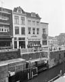
 Donkere Sluis - Dubbele Buurt.jpg 612 × 816; 573 KB
-
 Donkere sluis 01. In Gouda.JPG 4,320 × 3,240; 5.94 MB
-
 Donkere sluis 02. In Gouda.JPG 4,320 × 3,240; 5.53 MB
-
 Donkere sluis 03 Info. In Gouda.JPG 4,320 × 3,240; 5.69 MB
-
 Donkere sluis dicht.png 740 × 730; 6 KB
-
 Donkere sluis Gouda.jpg 1,200 × 906; 242 KB
-
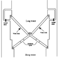
 Donkere sluis keersluis.png 1,772 × 2,059; 11 KB
-
 Donkere sluis open.png 724 × 746; 5 KB
-

-

-
 Donkere Sluis01.jpg 2,448 × 3,264; 5.32 MB
-
 Donkeresluis tussen Oost- en Westhaven Dubbele Buurt. - Gouda - 20081407 - RCE.jpg 1,200 × 1,195; 283 KB
-
 DonkereSluis02.jpg 3,265 × 2,447; 5.33 MB
-
 DonkereSluis03.jpg 2,447 × 3,265; 4.51 MB
-
 Exterieur ACHTERGEVEL, GEDEELTE - Gouda - 20285635 - RCE.jpg 1,195 × 1,200; 279 KB
-
 Exterieur ACHTERGEVEL, GEDEELTE - Gouda - 20285636 - RCE.jpg 1,192 × 1,200; 256 KB
-
 Exterieur OVERZICHT ACHTERGEVELS - Gouda - 20285634 - RCE.jpg 1,192 × 1,200; 272 KB
-
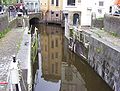
 Gouda. De Donkere sluis.jpg 4,770 × 3,177; 2.48 MB
-
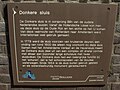 Gouda. Tekst en uitleg bij de Donkere sluis.jpg 4,005 × 3,002; 2.04 MB
-

-
 Overzicht met voorgevels - Gouda - 20358525 - RCE.jpg 1,183 × 1,200; 317 KB
-
 Overzicht van de achtergevels aan de gracht - Gouda - 20379860 - RCE.jpg 1,200 × 1,189; 244 KB
-
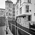
 Overzicht van sluis in de gracht - Gouda - 20350213 - RCE.jpg 1,200 × 778; 197 KB
-
 Overzicht voorgevel - Gouda - 20082964 - RCE.jpg 962 × 1,200; 199 KB
-
 Overzicht voorgevel - Gouda - 20082965 - RCE.jpg 946 × 1,200; 195 KB
-
 Water & Heritage Awareness schildje, Donkere sluis, Gouda.jpg 3,373 × 1,904; 4.3 MB


