Category:Dorfkirche Buchholz (Altlandsberg)
Jump to navigation
Jump to search
| Object location | | View all coordinates using: OpenStreetMap |
|---|
church building in Brandenburg state, Germany  | |||||
| Upload media | |||||
| Instance of | |||||
|---|---|---|---|---|---|
| Location | Altlandsberg, Märkisch-Oderland District, Brandenburg, Germany | ||||
| Heritage designation | |||||
 | |||||
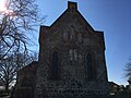
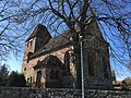
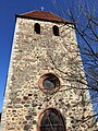
English: Pictures of the church in Buchholz , Altlandsberg municipality, Märkisch-Oderland district, Brandenburg state, Germany
Deutsch: Bilder der Kirche in Buchholz , Stadt Altlandsberg, Landkreis Märkisch-Oderland, Land Brandenburg, Deutschland.
Français : Photos de l'église à Buchholz , ville de Altlandsberg, arrondissement de Märkisch-Oderland, état fédéral de Brandebourg, Allemagne
This is the category of the Brandenburger Baudenkmal (cultural heritage monument) with the ID 09180378 (Wikidata)
|
Subcategories
This category has only the following subcategory.
K
Media in category "Dorfkirche Buchholz (Altlandsberg)"
The following 25 files are in this category, out of 25 total.
-
 Dorfkirche Buchholz Denkmal Gefallene WK II.jpg 4,032 × 3,024; 5.44 MB
-
 Dorfkirche Buchholz Nordansicht März 2018.jpg 4,032 × 3,024; 3.34 MB
-
 Dorfkirche Buchholz Nordostansicht März 2018.jpg 3,024 × 4,032; 1.87 MB
-
 Dorfkirche Buchholz Ostansicht.jpg 4,032 × 3,024; 2.99 MB
-
 Dorfkirche Buchholz Südansicht.jpg 4,032 × 3,024; 5.78 MB
-
 Dorfkirche Buchholz Südostansicht.jpg 4,032 × 3,024; 5.4 MB
-
 Dorfkirche Buchholz Südsakristei.jpg 3,024 × 4,032; 4.73 MB
-
 Dorfkirche Buchholz Südwestansicht mit Einfriedung.jpg 3,024 × 4,032; 5.05 MB
-
 Dorfkirche Buchholz Südwestansicht.jpg 4,032 × 3,024; 4.51 MB
-
 Dorfkirche Buchholz Westturm Nordansicht März 2018.jpg 3,024 × 4,032; 2.31 MB
-
 Dorfkirche Buchholz Westturm Südwestansicht.jpg 3,024 × 4,032; 3.73 MB
-
 Dorfkirche Buchholz Westturm Westansicht März 2018.jpg 3,024 × 4,032; 4.85 MB
-
 Dorfkirche Buchholz Westturm Westportal.jpg 4,032 × 3,024; 4.29 MB
-
 Dorfkirche und Friedhof Buchholz 10.JPG 4,608 × 3,072; 7.21 MB
-
 Dorfkirche und Friedhof Buchholz 11.JPG 3,072 × 4,608; 6.27 MB
-
 Dorfkirche und Friedhof Buchholz 12.JPG 4,608 × 3,072; 7.21 MB
-
 Dorfkirche und Friedhof Buchholz 15.JPG 4,608 × 3,072; 8.71 MB
-
 Dorfkirche und Friedhof Buchholz 16.JPG 3,072 × 4,608; 6.99 MB
-
 Dorfkirche und Friedhof Buchholz 17.JPG 4,608 × 3,072; 7.77 MB
-
 Dorfkirche und Friedhof Buchholz 18.JPG 3,072 × 4,608; 7.12 MB
-
 Dorfkirche und Friedhof Buchholz 30.JPG 3,072 × 4,608; 7.28 MB
-
 Dorfkirche und Friedhof Buchholz 31.JPG 3,072 × 4,608; 7.9 MB
-
 Dorfkirche und Friedhof Buchholz 32.JPG 3,072 × 4,608; 7.02 MB
-
 Dorfkirche und Friedhof Buchholz 33.JPG 3,072 × 4,608; 6.96 MB
-
 Dorfkirche und Friedhof Buchholz 34.JPG 4,608 × 3,072; 7.51 MB


