Category:Dorfkirche Dyrotz
Jump to navigation
Jump to search
| Object location | | View all coordinates using: OpenStreetMap |
|---|
 | |||||
| Upload media | |||||
| Instance of | |||||
|---|---|---|---|---|---|
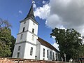
| Location | Dyrotz, Wustermark, Havelland District, Brandenburg, Germany | ||||
| Heritage designation | |||||
 | |||||
This is the category of the Brandenburger Baudenkmal (cultural heritage monument) with the ID 09150393 (Wikidata)
|
Français : Église de Dyrotz, commune de Wustermark, arrondissement Pays de la Havel, état fédéral de Brandebourg, Allemagne
Media in category "Dorfkirche Dyrotz"
The following 24 files are in this category, out of 24 total.
-
 Dorfkirche Dyrotz Denkmal Weltkriege.jpg 4,032 × 3,024; 4.86 MB
-
 Dorfkirche Dyrotz Gräber Gutsbesitzer Kobitz.jpg 4,032 × 3,024; 4.56 MB
-
 Dorfkirche Dyrotz Kreuz Südwand Kirchturm und Westwand Schiff.jpg 3,024 × 4,032; 2.18 MB
-
 Dorfkirche Dyrotz Nordansicht.jpg 4,032 × 3,024; 2.32 MB
-
 Dorfkirche Dyrotz Ostansicht.jpg 4,032 × 3,024; 2.82 MB
-
 Dorfkirche Dyrotz Portal.jpg 4,032 × 3,024; 3.69 MB
-
 Dorfkirche Dyrotz Südansicht.jpg 4,032 × 3,024; 5.07 MB
-
 Dorfkirche Dyrotz Südpforte Chor.jpg 4,032 × 3,024; 2.37 MB
-
 Dorfkirche Dyrotz Südporte mittig.jpg 4,032 × 3,024; 2.64 MB
-
 Dorfkirche Dyrotz Südwestansicht.jpg 4,032 × 3,024; 2.78 MB
-
 Dorfkirche Dyrotz Westturm Nordwestansicht Erdgeschoss.jpg 3,024 × 4,032; 1.69 MB
-
 Dorfkirche Dyrotz Westturm Nordwestansicht Glockengeschoss.jpg 3,024 × 4,032; 1.56 MB
-
 Dorfkirche Dyrotz Westturm Südansicht Glockengeschoss.jpg 3,024 × 4,032; 1.5 MB
-
 Dorfkirche Dyrotz Westturm Westansicht Glockengeschoss.jpg 3,024 × 4,032; 2.07 MB
-
 Dorfkirche Dyrotz Westturm Westportal.jpg 4,032 × 3,024; 2.52 MB
-
 Dyrotz - Dorfkirche (Village Church) - geo.hlipp.de - 43336.jpg 480 × 640; 67 KB
-
 Dyrotz church 2016 NE.JPG 5,116 × 4,381; 7.86 MB
-
 Dyrotz church 2016 portal S.JPG 3,648 × 4,864; 5.65 MB
-
 Dyrotz church 2016 portal W.JPG 3,648 × 4,864; 5.49 MB
-
 Dyrotz church 2016 S.jpg 5,005 × 4,579; 8.07 MB
-
 Dyrotz church 2016 SSE.JPG 4,864 × 3,648; 8.43 MB
-
 Dyrotz church 2016 SW.JPG 4,864 × 3,648; 4.8 MB
-
 Dyrotz church 2016 W.JPG 4,864 × 3,648; 4.8 MB
-
 Dyrotz church 2016 WSW.JPG 3,648 × 4,864; 4.47 MB


_-_geo.hlipp.de_-_43336.jpg)


