Category:Dorfkirche Läsikow
Jump to navigation
Jump to search
| Object location | | View all coordinates using: OpenStreetMap |
|---|
church building in Ostprignitz-Ruppin district, Brandenburg state, Germany  | |||||
| Upload media | |||||
| Instance of | |||||
|---|---|---|---|---|---|
| Location | Läsikow, Wusterhausen/Dosse, Ostprignitz-Ruppin District, Brandenburg, Germany | ||||
| Heritage designation | |||||
| Inception |
| ||||
 | |||||
This is the category of the Brandenburger Baudenkmal (cultural heritage monument) with the ID 09170620 (Wikidata)
|
English: Pictures of the church in Läsikow, Wusterhausen/Dosse municipality, Ostprignitz-Ruppin district, Brandenburg state, Germany.
Deutsch: Ansichten der Kirche in Läsikow, Gemeinde Wusterhausen/Dosse, Landkreis Ostprignitz-Ruppin, Land Brandenburg, Deutschland.
Français : Photos de l'église à Läsikow, commune de Wusterhausen/Dosse, arrondissement de Ostprignitz-Ruppin, état fédéral de Brandebourg, Allemagne
Español: Vistas de la iglesia en Läsikow, municipio de Wusterhausen/Dosse, distrito de Ostprignitz-Ruppin, estado federado de Brandeburgo, Alemania
Address:
Läsikower Ring, 16845 Läsikow, Wusterhausen/Dosse
Subcategories
This category has only the following subcategory.
I
Pages in category "Dorfkirche Läsikow"
This category contains only the following page.
Media in category "Dorfkirche Läsikow"
The following 26 files are in this category, out of 26 total.
-
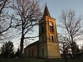
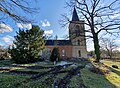
 Dorfkirche Läsikow 2015 N.jpg 2,592 × 1,944; 2.28 MB
-
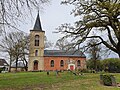
 Dorfkirche Läsikow 2015 NW.jpg 2,592 × 1,944; 2.22 MB
-
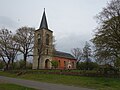
 Dorfkirche Läsikow 2015 S.jpg 2,592 × 1,944; 2.18 MB
-
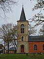
 Dorfkirche Läsikow 2015 SE.jpg 2,592 × 1,944; 2.22 MB
-
 Dorfkirche Läsikow 2015 SW.jpg 2,592 × 1,944; 2.15 MB
-
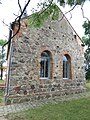
 Dorfkirche Läsikow 2021 Fenster.jpg 3,648 × 4,864; 6.88 MB
-
 Dorfkirche Läsikow 2021 NE.jpg 4,464 × 3,354; 4.49 MB
-
 Dorfkirche Läsikow 2021 NNE.jpg 4,864 × 3,648; 5.86 MB
-
 Dorfkirche Läsikow 2021 S.jpg 3,985 × 2,998; 4.86 MB
-
 Dorfkirche Läsikow 2021 SW.jpg 4,864 × 3,648; 5.98 MB
-
 Dorfkirche Läsikow 2021 Südostportal.jpg 3,648 × 4,864; 7.28 MB
-
 Dorfkirche Läsikow 2021 Südwestportal.jpg 3,648 × 4,864; 6.8 MB
-
 Dorfkirche Läsikow 2021 Turm.jpg 3,509 × 4,679; 3.56 MB
-
 Dorfkirche Läsikow 2023 Gefallenentafel WK I und II.jpg 2,554 × 3,406; 1.5 MB
-
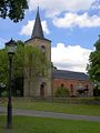
 Dorfkirche Läsikow 2023 N.jpg 4,392 × 3,228; 3.86 MB
-
 Dorfkirche Läsikow 2023 S.jpg 3,648 × 2,736; 3.38 MB
-
 Dorfkirche Läsikow 2023 Turmhelm.jpg 2,395 × 3,593; 1.3 MB
-
 Dorfkirche Läsikow Nordseite.jpg 3,000 × 4,000; 2.77 MB
-
 Laesikow church.jpg 1,080 × 1,440; 235 KB
-
 Läsikow Dorfkirche 2.jpg 4,000 × 3,000; 2.77 MB
-
 Läsikow Kirche 1.jpg 4,000 × 3,000; 4.38 MB
-
 Läsikow Kirche Chor Nordseite.jpg 4,000 × 3,000; 4.21 MB
-
 Läsikow Kirche Chor Ostseite.jpg 3,000 × 4,000; 3.81 MB
-
 Läsikow Kirche Chor Südseite.jpg 4,000 × 3,000; 3.81 MB
-
 Läsikow Kirche Südseite.jpg 4,000 × 3,000; 3.36 MB
-
 Läsikow Kirche Turm Westseite.jpg 3,000 × 4,000; 4.41 MB


Categories:
- Churches in Wusterhausen/Dosse
- Cultural heritage monuments in Wusterhausen/Dosse
- Läsikow
- Churches in Kirchenkreis Prignitz
- Lutheran churches in Brandenburg
- Fieldstone churches in Brandenburg
- Romanesque Revival brick churches in Brandenburg
- Churches in Brandenburg built in 1867
- 1860s brick churches in Brandenburg