Category:Draycott in the Moors
Aller à la navigation
Aller à la recherche
English: Draycott in the Moors is a village between Newcastle-under-Lyme and Uttoxeter near the River Blythe. It is two and a half miles from Cheadle and is near Blythe Bridge railway station, on the North Staffordshire Railway.
village britannique  | |||||
| Téléverser des médias | |||||
| Nature de l’élément | |||||
|---|---|---|---|---|---|
| Lieu | Staffordshire Moorlands, Staffordshire, Midlands de l'Ouest, Angleterre | ||||
| Population |
| ||||
| Réputé identique à | Draycott in the Moors (page en doublon, paroisse civile) | ||||
 | |||||
Sous-catégories
Cette catégorie comprend 4 sous-catégories, dont les 4 ci-dessous.
C
- Cresswell Pumping Station (4 F)
D
- Draycott Cross Colliery (vide)
Média dans la catégorie « Draycott in the Moors »
Cette catégorie comprend 53 fichiers, dont les 53 ci-dessous.
-
 A50 - footbridge near Cresswell - geograph.org.uk - 2342244.jpg 640 × 480 ; 55 kio
-
 A50 - lay-by near Woodlands - geograph.org.uk - 2342266.jpg 640 × 480 ; 61 kio
-
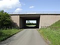
 A50 about to bridge Cresswell Old Lane - geograph.org.uk - 2342197.jpg 640 × 480 ; 45 kio
-
 A50 Bridge Over Cresswell Old Lane - geograph.org.uk - 437248.jpg 640 × 480 ; 68 kio
-
 A50 crossed by power lines near Cresswell - geograph.org.uk - 2342205.jpg 640 × 480 ; 55 kio
-
 A50 east of Lower Newton Farm - geograph.org.uk - 3593065.jpg 640 × 480 ; 35 kio
-
 A50 eastbound near Cresswell - geograph.org.uk - 3593059.jpg 640 × 480 ; 39 kio
-
 A50 eastbound near Cresswell - geograph.org.uk - 3593062.jpg 640 × 481 ; 31 kio
-
 A50 near Upper Newton Farm - geograph.org.uk - 2342183.jpg 640 × 480 ; 50 kio
-
 Bird in Hand, Hilderstone - geograph.org.uk - 1868197.jpg 640 × 480 ; 51 kio
-
 Cutting on abandoned railway at Totmonslow - geograph.org.uk - 2860016.jpg 768 × 1 024 ; 355 kio
-
 Draycott Arms.jpg 640 × 480 ; 81 kio
-
 Draycott Old Road, looking north-west - geograph.org.uk - 6679488.jpg 1 600 × 1 200 ; 432 kio
-
 Draycott Old Road, looking south-east - geograph.org.uk - 6679493.jpg 1 600 × 1 200 ; 423 kio
-
 Draycott railway tunnel – Draycott end.jpg 1 500 × 2 316 ; 2,65 Mio
-
 Draycott trig - geograph.org.uk - 409111.jpg 640 × 480 ; 177 kio
-

-
 Electricity Pylon - Draycott in the Moors - geograph.org.uk - 3936269.jpg 2 983 × 3 846 ; 4,54 Mio
-
 Farm track with broken culvert, approaching Paynsley - geograph.org.uk - 3522287.jpg 1 200 × 1 600 ; 613 kio
-
 Field access track, Draycott in the Moors - geograph.org.uk - 6679498.jpg 1 600 × 1 200 ; 468 kio
-
 Footbridge over A50 near Cresswell - geograph.org.uk - 3592769.jpg 1 024 × 683 ; 80 kio
-
 Footbridge over the A50 near Cresswell - geograph.org.uk - 4241564.jpg 640 × 480 ; 244 kio
-
 Ford at Draycott in the Moors - geograph.org.uk - 5272343.jpg 3 000 × 2 000 ; 5,7 Mio
-
 Houses on the west side of Sandon Road, Cresswell - geograph.org.uk - 6679484.jpg 1 600 × 1 200 ; 348 kio
-
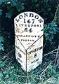
 How many miles to London^ - geograph.org.uk - 2859706.jpg 3 000 × 4 000 ; 3,29 Mio
-
 Huntley Wood quarry - geograph.org.uk - 2859662.jpg 4 000 × 2 248 ; 2,29 Mio
-
 Large field, north-west of Wastegate Farm - geograph.org.uk - 6679435.jpg 1 600 × 1 200 ; 442 kio
-

-
 Layby on A50 near Cresswell - geograph.org.uk - 4241571.jpg 640 × 427 ; 242 kio
-
 Layby on Westbound A50 - geograph.org.uk - 4241562.jpg 640 × 480 ; 247 kio
-
 Level crossing, Sandon Road, Cresswell - geograph.org.uk - 6679469.jpg 1 160 × 870 ; 292 kio
-
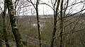
 Looking towards Huntley Wood - geograph.org.uk - 2860021.jpg 1 024 × 768 ; 138 kio
-
 Manhole on a water pipeline - geograph.org.uk - 6679475.jpg 1 600 × 1 200 ; 487 kio
-
 Milepost at SJ 9945039761.jpg 492 × 701 ; 72 kio
-
 Muddy track, off Sandon Road, Cresswell - geograph.org.uk - 6679483.jpg 1 600 × 1 200 ; 490 kio
-
 No parking sign, on the track to Wastegate Farm - geograph.org.uk - 6679427.jpg 1 600 × 1 200 ; 651 kio
-
 Ordnance Survey Cut Mark - geograph.org.uk - 5055339.jpg 4 000 × 3 000 ; 5,68 Mio
-
 Railway tracks at Cresswell - geograph.org.uk - 3936275.jpg 4 608 × 3 456 ; 6,33 Mio
-
 River Tean - downstream at Teanford - geograph.org.uk - 2394988.jpg 480 × 640 ; 91 kio
-
 Road Junction at Draycott Cross - geograph.org.uk - 463213.jpg 640 × 480 ; 81 kio
-
 Solar farm by railway line - geograph.org.uk - 5806256.jpg 4 032 × 3 024 ; 1,52 Mio
-
 Solar panels at Paynsley chicken farm - geograph.org.uk - 3522299.jpg 1 600 × 1 200 ; 489 kio
-
 Springhill Farm, Totmonslow - geograph.org.uk - 2859696.jpg 4 000 × 3 000 ; 2,19 Mio
-
 The Hunter Public House - geograph.org.uk - 3936281.jpg 2 842 × 2 546 ; 2,23 Mio
-
 The Hunter public house - geograph.org.uk - 6679455.jpg 1 600 × 1 200 ; 425 kio
-
 The Hunter Public House - geograph.org.uk - 6746999.jpg 1 024 × 768 ; 141 kio
-
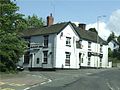
 The New Plough - geograph.org.uk - 437198.jpg 640 × 481 ; 82 kio
-
 The River Blithe, Cresswell - geograph.org.uk - 6679479.jpg 1 673 × 1 254 ; 653 kio
-
 This way to Wastegate Farm - geograph.org.uk - 6679431.jpg 1 600 × 1 200 ; 440 kio
-
 Track to New Buildings farm - geograph.org.uk - 5055193.jpg 4 000 × 3 000 ; 2,93 Mio
-
 Wastegate Farm, from the north-west - geograph.org.uk - 6679444.jpg 1 600 × 1 200 ; 505 kio
-
 Farm, Coneygreaves - geograph.org.uk - 463188.jpg 640 × 480 ; 77 kio
-
 Fields Farm - geograph.org.uk - 463220.jpg 640 × 480 ; 33 kio


_-_geograph.org.uk_-_1435607.jpg)


