Category:East Sussex
ナビゲーションに移動
検索に移動

イングランドの典礼カウンティ:Bedfordshire · Berkshire · Buckinghamshire · Cambridgeshire · Cheshire · Cornwall · Cumbria · Derbyshire · Devon · Dorset · Durham · East Riding of Yorkshire · East Sussex · Essex · Gloucestershire · Greater London · Greater Manchester · Hampshire · Herefordshire · Hertfordshire · Isle of Wight · Kent · Lancashire · Leicestershire · Lincolnshire · Merseyside · Norfolk · North Yorkshire · Northamptonshire · Northumberland · Nottinghamshire · Oxfordshire · Rutland · Shropshire · Somerset · South Yorkshire · Staffordshire · Suffolk · Surrey · Tyne and Wear · Warwickshire · West Midlands · West Sussex · West Yorkshire · Wiltshire · Worcestershire
City-counties:Bristol · City of London
Former historic counties:Cumberland · Huntingdonshire · London · Middlesex · North Riding of Yorkshire · Sussex · West Riding of Yorkshire · Westmorland · Yorkshire
Other former counties:Avon · Cambridgeshire and Isle of Ely · Cleveland · East Suffolk · Hereford and Worcester · Hexhamshire · Humberside · Huntingdon and Peterborough · Isle of Ely · Parts of Holland · Parts of Kesteven · Parts of Lindsey · Soke of Peterborough · West Suffolk

イングランドの州     | |||||
| メディアをアップロード | |||||
| 分類 |
| ||||
|---|---|---|---|---|---|
| 場所 | 南東イングランド, イングランド | ||||
| 行政中心地 | |||||
| 人口 |
| ||||
| 面積 |
| ||||
| 公式ウェブサイト | |||||
 | |||||
下位カテゴリ
このカテゴリに属する 57 個のサブカテゴリのうち、 57 個を表示しています。
!
*
- Valued images of East Sussex (7ファイル)
- Featured pictures of East Sussex (9ファイル)
A
B
C
D
- Dusk in East Sussex (14ファイル)
E
- Earthworks in East Sussex (5ファイル)
F
- Flagpoles in East Sussex (24ファイル)
G
- Gallery pages of East Sussex (5ページ)
H
I
J
M
- Morris dance in East Sussex (8ファイル)
N
O
- Oxteddle Bottom (6ファイル)
P
- Picnic tables in East Sussex (1ファイル)
S
T
- Traffic signals in East Sussex (36ファイル)
V
W
- Winter in East Sussex (6ファイル)
カテゴリ「East Sussex」にあるメディア
このカテゴリに属する 154 個のファイルのうち、 154 個を表示しています。
-
 2013-09-18 Cow Gap by Studiofootnotes.jpg 1,818 × 1,818;931キロバイト
-
 2013-09-18 Seven Sisters cliffs by Studiofootnotes.jpg 1,818 × 1,818;1.19メガバイト
-
 Beehives near Littledown Cottages - geograph.org.uk - 1154179.jpg 480 × 640;74キロバイト
-
 Beehives NW of Strood Farm - geograph.org.uk - 1388756.jpg 640 × 480;134キロバイト
-
 Bridge over the River Grom - geograph.org.uk - 1104078.jpg 640 × 430;91キロバイト
-
 Bridge over the River Grom - geograph.org.uk - 1151615.jpg 640 × 430;72キロバイト
-
 Bridges near High Rock Lane - geograph.org.uk - 1736814.jpg 2,304 × 3,072;2.79メガバイト
-
 Bridleway to Lunce's Common - geograph.org.uk - 843879.jpg 479 × 640;149キロバイト
-

-
 Browndown Wood - geograph.org.uk - 1251661.jpg 640 × 430;67キロバイト
-
 Bus on Pett Level Road - geograph.org.uk - 2339041.jpg 640 × 480;55キロバイト
-
 Bus on Pett Level Road - geograph.org.uk - 2339046.jpg 640 × 480;64キロバイト
-
 Chick Hill - Steep Hill 25^ - geograph.org.uk - 1430874.jpg 640 × 400;101キロバイト
-
 Common Lane - geograph.org.uk - 1446169.jpg 480 × 640;71キロバイト
-
 Common Lane - geograph.org.uk - 1450751.jpg 480 × 640;85キロバイト
-
 Cooksbridge Level Crossing (open).jpg 1,366 × 768;108キロバイト
-
 Denshire Field - geograph.org.uk - 1543739.jpg 640 × 480;79キロバイト
-
 Ditchling Road - geograph.org.uk - 1521064.jpg 480 × 640;81キロバイト
-
 East Sussex border post - geograph.org.uk - 1056483.jpg 640 × 430;116キロバイト
-
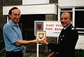 East Sussex Fire Brigade Lewes Chief Franz-Josef Sehr 1987-08-01.jpg 2,067 × 1,407;1.15メガバイト
-
 Electric fence equipment - geograph.org.uk - 807354.jpg 640 × 480;111キロバイト
-
 Elphicks Farm - geograph.org.uk - 1446199.jpg 480 × 640;91キロバイト
-
 Fallen tree, Beckington Wood - geograph.org.uk - 1251720.jpg 640 × 430;145キロバイト
-
 Field Systems south of the Chattri - geograph.org.uk - 1421559.jpg 640 × 480;55キロバイト
-
-

-
 Footpath leading to Beckington Wood - geograph.org.uk - 1251709.jpg 640 × 430;83キロバイト
-
 Footpath signpost south of Dunstan's Wood - geograph.org.uk - 1251692.jpg 640 × 430;109キロバイト
-
 Footpath through Beckington Wood - geograph.org.uk - 1251722.jpg 640 × 430;153キロバイト
-
 Fountain Wood - geograph.org.uk - 1251685.jpg 640 × 430;132キロバイト
-
 Groynes on Cliff End beach - geograph.org.uk - 437492.jpg 640 × 480;67キロバイト
-

-
 Haywards Heath banner Borde Hill Place.jpg 3,994 × 571;855キロバイト
-
 Image-KentGeologyWealdenDome 1.svg 744 × 347;31キロバイト
-
 Janes Lane - geograph.org.uk - 1446412.jpg 480 × 640;101キロバイト
-
 Kent East Sussex Downs.svg 625 × 312;27キロバイト
-
 KentGeologyWealdenDome 2.svg 744 × 1,052;30キロバイト
-
 KentGeologyWealdenDome.svg 625 × 312;31キロバイト
-
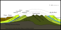 KentGeologyWealdenDomeSimple.svg 625 × 312;27キロバイト
-
 Ladycross 1959.jpg 7,323 × 1,632;1.89メガバイト
-
 Last Days (85567695).jpeg 492 × 800;164キロバイト
-
 Lewes Road - geograph.org.uk - 1474715.jpg 640 × 480;126キロバイト
-
 Lewes Road - geograph.org.uk - 1521053.jpg 480 × 640;86キロバイト
-
 Looking South to Furnace Wood - geograph.org.uk - 1251681.jpg 640 × 430;42キロバイト
-
 Lower Hook Wood - geograph.org.uk - 1573430.jpg 640 × 480;84キロバイト
-
 Marina at Newhaven - geograph.org.uk - 23936.jpg 640 × 480;102キロバイト
-
 More House Farm - geograph.org.uk - 843866.jpg 640 × 479;101キロバイト
-
 National Cycle Route 21 south of Mayfield - geograph.org.uk - 47264.jpg 640 × 427;135キロバイト
-
 New Road - geograph.org.uk - 1455252.jpg 480 × 640;71キロバイト
-
 New Road - geograph.org.uk - 1455284.jpg 480 × 640;55キロバイト
-
 Old Massey Ferguson Tractor, Heaven Farm, East Sussex (24060146656).jpg 4,160 × 2,340;4.73メガバイト
-
 Pill Boxes, Cliff End - geograph.org.uk - 620393.jpg 640 × 479;98キロバイト
-

-
 Pond on the edge of Browndown Wood - geograph.org.uk - 1251658.jpg 640 × 430;86キロバイト
-
 Road junction with B2188 - geograph.org.uk - 1242766.jpg 640 × 480;127キロバイト
-
 Rockfalls near Portobello - geograph.org.uk - 1204981.jpg 480 × 640;136キロバイト
-
 Sea Wall Gate - geograph.org.uk - 437539.jpg 640 × 480;57キロバイト
-
 Staplecross Nursery - geograph.org.uk - 2339024.jpg 640 × 480;96キロバイト
-
 Stile and a large Oak tree by the River Grom - geograph.org.uk - 1151954.jpg 640 × 430;124キロバイト
-

-
 Stile entering Beckington Wood - geograph.org.uk - 1251715.jpg 640 × 430;136キロバイト
-
 Stile on the edge of Browndown Wood - geograph.org.uk - 1251667.jpg 640 × 430;98キロバイト
-
-
 Sussex wood.jpg 579 × 416;115キロバイト
-
 The 'Padlock Sculpture' at Warrior Square, St.Leonards on sea. (8063216770).jpg 1,866 × 2,873;979キロバイト
-

-
 The Bathing Pool , St.Leonards on sea. c1987 (14450548096).jpg 1,007 × 1,405;298キロバイト
-
 The Bathing Pool, St.Leonards on sea, c.1950 (8879583631).jpg 1,593 × 1,129;941キロバイト
-
 The border stream - geograph.org.uk - 1056490.jpg 640 × 430;138キロバイト
-
 The edge of St Dunstan's Wood - geograph.org.uk - 1251674.jpg 640 × 430;118キロバイト
-
 The Old Post Office - geograph.org.uk - 1508661.jpg 480 × 640;58キロバイト
-
 The Weald - geograph.org.uk - 505343.jpg 640 × 479;131キロバイト
-
 This Is My Best Side - geograph.org.uk - 1449378.jpg 480 × 640;81キロバイト
-
 Thundersbarrow Hill - geograph.org.uk - 54113.jpg 640 × 479;161キロバイト
-
 Toot Rock look-out - geograph.org.uk - 437549.jpg 640 × 480;111キロバイト
-
 Trailmark on the South Downs Way, Sussex, UK.jpg 1,024 × 768;273キロバイト
-
 Unharvested Corn Field - geograph.org.uk - 1554255.jpg 640 × 480;144キロバイト
-
 View from caravan at Heaven Farm, East Sussex (24060257806).jpg 2,592 × 1,936;1.37メガバイト
-
 View of Borde Hill Place 3.jpg 3,994 × 2,943;3.73メガバイト
-
 Welcome to East Sussex, B2026 - geograph.org.uk - 1375314.jpg 640 × 430;168キロバイト
-
 Winkle - geograph.org.uk - 462492.jpg 640 × 427;52キロバイト
-
 Young apple orchard - geograph.org.uk - 456751.jpg 640 × 480;123キロバイト
-
 Ancient Field System, Eastdean Down - geograph.org.uk - 147244.jpg 640 × 479;123キロバイト
-
-
 Arlington Stadium - geograph.org.uk - 62671.jpg 640 × 479;102キロバイト
-
 Ash Farm - geograph.org.uk - 1133775.jpg 640 × 480;81キロバイト
-
 At the Foot of the Marshes - geograph.org.uk - 701312.jpg 640 × 479;86キロバイト
-
 Bagged up silage - geograph.org.uk - 484023.jpg 640 × 480;92キロバイト
-
 Beach and Groynes, Pett levels - geograph.org.uk - 69677.jpg 640 × 480;139キロバイト
-

-
 Culvert under Track, Jews Wood - geograph.org.uk - 339342.jpg 428 × 640;170キロバイト
-
 Derelict Depot - geograph.org.uk - 323319.jpg 640 × 479;141キロバイト
-
 Dew pond on Sweet Hill - geograph.org.uk - 388626.jpg 640 × 480;102キロバイト
-
 Disused Factory, Hampden Park - geograph.org.uk - 179003.jpg 640 × 479;192キロバイト
-
 Dog Training Equipment - geograph.org.uk - 460757.jpg 640 × 479;123キロバイト
-
 Drainage works near Wisketts wood - geograph.org.uk - 251136.jpg 640 × 480;132キロバイト
-
 Embankment, Clff End - geograph.org.uk - 771788.jpg 640 × 430;66キロバイト
-
 Embankment, Pett Levels - geograph.org.uk - 69675.jpg 640 × 480;114キロバイト
-
 Entering Kent - geograph.org.uk - 293685.jpg 640 × 427;80キロバイト
-
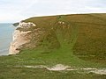
 Fairlight Head - geograph.org.uk - 69684.jpg 640 × 480;82キロバイト
-
 Feeding Time at Primrose Farm - geograph.org.uk - 614516.jpg 479 × 640;104キロバイト
-
 Field Boundary - geograph.org.uk - 642888.jpg 479 × 640;197キロバイト
-
 Fishing Pools at Mill Brook - geograph.org.uk - 36462.jpg 640 × 480;335キロバイト
-
 Former inlet, Seaford - geograph.org.uk - 122187.jpg 640 × 479;97キロバイト
-
 Freshfield Lane Brickworks - geograph.org.uk - 24703.jpg 640 × 480;136キロバイト
-
 Garden Centre Car Park - geograph.org.uk - 1425489.jpg 640 × 480;93キロバイト
-
 Ham Road Orphanage - geograph.org.uk - 60852.jpg 640 × 479;109キロバイト
-
 Hay meadow near Ashburnham Ford - geograph.org.uk - 358675.jpg 640 × 386;122キロバイト
-
 Heathland and woodland - geograph.org.uk - 182677.jpg 640 × 480;173キロバイト
-
 Hesmond Stud - geograph.org.uk - 383710.jpg 640 × 479;169キロバイト
-
 Hooe Level - geograph.org.uk - 701307.jpg 640 × 479;102キロバイト
-
 Inside the Derelict Depot. - geograph.org.uk - 323325.jpg 479 × 640;117キロバイト
-
 Limekiln Bottom - geograph.org.uk - 620294.jpg 640 × 479;84キロバイト
-
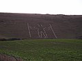 Long Man of Wilmington - geograph.org.uk - 349539.jpg 640 × 479;61キロバイト
-
 Meadows by the Huglett's Stream - geograph.org.uk - 461072.jpg 640 × 480;112キロバイト
-
 Mill Hill, Shoreham - geograph.org.uk - 47967.jpg 640 × 479;119キロバイト
-
 Moat, Moat Wood - geograph.org.uk - 323282.jpg 479 × 640;221キロバイト
-
 Nate Wood - geograph.org.uk - 62683.jpg 640 × 479;174キロバイト
-
 Orchard windbreak hedge - geograph.org.uk - 392168.jpg 428 × 640;403キロバイト
-
 Paddock adjacent to Kidd's Hill - geograph.org.uk - 697695.jpg 640 × 480;111キロバイト
-
 Pett Level and Winchelsea Beach - geograph.org.uk - 111313.jpg 640 × 430;122キロバイト
-
 Picnic Site, Footland Wood - geograph.org.uk - 340137.jpg 640 × 480;151キロバイト
-
 Ratton Village from Butts Brow - geograph.org.uk - 131950.jpg 479 × 640;148キロバイト
-
 Remains of a Cross, near Firle - geograph.org.uk - 177448.jpg 479 × 640;172キロバイト
-
 Roman road near Holtye - geograph.org.uk - 48316.jpg 640 × 427;154キロバイト
-
 Rough Bottom - geograph.org.uk - 620270.jpg 640 × 479;79キロバイト
-
 Rough Bottom - geograph.org.uk - 620283.jpg 640 × 479;112キロバイト
-
 Sea Defences at Seaford - geograph.org.uk - 223565.jpg 640 × 426;139キロバイト
-
 Short Bottom - geograph.org.uk - 620299.jpg 640 × 479;89キロバイト
-
 Short Bottom - geograph.org.uk - 620306.jpg 640 × 479;115キロバイト
-
 Sloping and curved sea wall - geograph.org.uk - 69680.jpg 640 × 480;137キロバイト
-

-
 Stone Farm rocks - geograph.org.uk - 23464.jpg 640 × 480;142キロバイト
-
 Stone Mason's Yard at Lower Vert Wood - geograph.org.uk - 149466.jpg 640 × 480;277キロバイト
-
 Students on the beach, below Fairlight Head. - geograph.org.uk - 190078.jpg 640 × 480;151キロバイト
-
-
 Tanyard Fisheries - geograph.org.uk - 54534.jpg 640 × 480;301キロバイト
-
 Tenacre Farm Nursery - geograph.org.uk - 333058.jpg 640 × 480;110キロバイト
-
 Tennis Courts, Recreation Ground - geograph.org.uk - 323368.jpg 640 × 479;94キロバイト
-
 Towards Firle - geograph.org.uk - 3182.jpg 640 × 480;84キロバイト
-
 Troop B 4 Ever - geograph.org.uk - 620317.jpg 640 × 479;79キロバイト
-
 Under Southwick Hill (Westbound) - geograph.org.uk - 179566.jpg 640 × 479;42キロバイト
-
 Under Southwick Hill - geograph.org.uk - 179558.jpg 640 × 479;47キロバイト
-
 Undercliff walk - Peacehaven - geograph.org.uk - 229231.jpg 573 × 638;460キロバイト
-

-
 View from Wick Wood - geograph.org.uk - 326183.jpg 640 × 428;78キロバイト
-
 View of South Coast from East Brighton - geograph.org.uk - 89468.jpg 640 × 479;53キロバイト
-
 View south from Udiam Lane - geograph.org.uk - 386329.jpg 640 × 428;131キロバイト
-
 View west of Newick Lane - geograph.org.uk - 333123.jpg 640 × 480;112キロバイト
-
 Visitor Centre at Exceat - geograph.org.uk - 36358.jpg 640 × 449;79キロバイト
-

-
 Waves breach the sea defences - geograph.org.uk - 42465.jpg 640 × 614;149キロバイト
-

-
 Wych Cross Garden Centre - geograph.org.uk - 335006.jpg 640 × 480;88キロバイト


.jpg)


.jpeg)


.jpg)


.jpg)
.jpg)
.jpg)
.jpg)


.jpg)


_-_geograph.org.uk_-_179566.jpg)


