Category:Eerste Compagnonsweg 1, Bontebok
Jump to navigation
Jump to search
| Object location | | View all coordinates using: OpenStreetMap |
|---|
farmhouse in Heerenveen, Netherlands  | |||||
| Upload media | |||||
| Instance of | |||||
|---|---|---|---|---|---|
| Location | Bontebok, Heerenveen, Heerenveen, Friesland, Netherlands | ||||
| Located on street |
| ||||
| Architectural style | |||||
| Heritage designation |
| ||||
 | |||||
|
This is a category about rijksmonument number 510496
|
| Address |
|
Media in category "Eerste Compagnonsweg 1, Bontebok"
The following 4 files are in this category, out of 4 total.
-
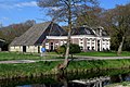 2023 Bontebok, pleats Earste Kompanjonswei 1.jpg 2,669 × 1,780; 1.53 MB
-
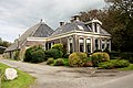 Bontebok 510496.jpg 3,888 × 2,592; 3.66 MB
-
 Voorgevel nr. L 59 - De Bontebok - 20476708 - RCE.jpg 1,200 × 900; 268 KB
-
 Zijgevel nr. L 58 - De Bontebok - 20476709 - RCE.jpg 1,200 × 900; 223 KB


