Category:Eschbach (Usingen)
Saltar para a navegação
Saltar para a pesquisa
municipal district of Usingen in Hochtaunuskreis, Germany  .png)  | |||||
| Carregar ficheiro | |||||
| Instância de |
| ||||
|---|---|---|---|---|---|
| Localização | Usingen, Hochtaunuskreis, Darmstadt, Hesse, Alemanha | ||||
| Área |
| ||||
| Altitude |
| ||||
 | |||||
Subcategorias
Esta categoria contém as seguintes 5 subcategorias (de um total de 5).
Multimédia na categoria "Eschbach (Usingen)"
Esta categoria contém os seguintes 72 ficheiros (de um total de 72).
-
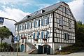 Alte Schule Eschbach 1.jpg 5 182 × 3 455; 2,71 MB
-
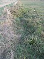
 Dittenbach auf Weide ober Teichen R0020419.jpg 3 648 × 2 736; 3,5 MB
-
 Dittenbach Beginn Acker Im Gauroth R0020478.jpg 2 736 × 3 648; 3,71 MB
-
 Dittenbach Beginn Acker Im Gauroth R0020480.jpg 3 648 × 2 736; 3,63 MB
-
 Dittenbach Furt Im Gauroth R0020469.jpg 2 736 × 3 648; 3,67 MB
-
 Dittenbach Knick Acker Im Gauroth R0020473.jpg 3 648 × 2 736; 3,66 MB
-
 Dittenbach nass Im Gauroth R0020471.jpg 2 736 × 3 648; 3,7 MB
-
 Dittenbach Oben im Strüthchen R0020441.jpg 3 648 × 2 736; 3,62 MB
-
 Dittenbach ober Durchlass K 727 R0020435.jpg 3 648 × 2 736; 3,18 MB
-
 Dittenbach Sickerquellen unter Gauroth R0020462.jpg 3 648 × 2 736; 3,7 MB
-
 Dittenbach unter Brücke Usinger Weg R0020425.jpg 3 648 × 2 736; 3,56 MB
-
 Elsbeeren an Schmalbach-Quelle R0020035.jpg 3 648 × 2 736; 3,74 MB
-
 Eschbach-Winter-2017-1.jpg 6 016 × 4 000; 8,45 MB
-
 Herrschaftlicher Hof 3.jpg 5 740 × 3 896; 12,01 MB
-
 Karte Usingen Eschbach.svg 814 × 683; 30 kB
-
 Michelbach am Beginn Rinne von Wiese R0020177.jpg 3 648 × 2 736; 3,66 MB
-
 Michelbach felsiges Bett ober Zufluss 24848294 R0018782.jpg 2 736 × 3 648; 3,68 MB
-
 Michelbach in Quellwiese ober Knick vom Wald R0020192.jpg 3 648 × 2 736; 3,7 MB
-
 Michelbach ober Quellwiese am Kahlschlag R0020214.jpg 3 648 × 2 736; 3,7 MB
-
 Michelbach ober Quellwiese im Nadelwald R0020206.jpg 3 648 × 2 736; 3,54 MB
-
 Michelbach ober Quellwiese im Nadelwald R0020212.jpg 3 648 × 2 736; 3,73 MB
-
 Michelbach ober Quellwiese im Waldrand R0020205.jpg 2 736 × 3 648; 3,71 MB
-
 Michelbach ober Teiche an Quellwiese R0020187.jpg 2 736 × 3 648; 3,65 MB
-
 Michelbach ober Teiche im Waldriegel R0020186.jpg 2 736 × 3 648; 3,64 MB
-
 Michelbach ober Teiche R0020139.jpg 3 648 × 2 736; 3,69 MB
-
 Michelbach ober Weg R0020146.jpg 3 648 × 2 736; 3,58 MB
-
 Michelbach ober Weg R0020148.jpg 3 648 × 2 736; 3,67 MB
-
 Michelbach obere Teiche Beginn Rinne an Wiese R0020175.jpg 3 648 × 2 736; 3,63 MB
-
 Michelbach obere Teiche Element Damm R0020156.jpg 2 736 × 3 648; 3,54 MB
-
 Michelbach obere Teiche Hainbuchenhecke R0020166.jpg 3 648 × 2 736; 3,71 MB
-
 Michelbach obere Teiche Hainbuchenhecke R0020221.jpg 3 648 × 2 736; 3,7 MB
-
 Michelbach obere Teiche Hainbuchenhecke R0020222.jpg 3 648 × 2 736; 3,7 MB
-
 Michelbach obere Teiche Rinne R0020154.jpg 3 648 × 2 736; 3,65 MB
-
 Michelbach obere Teiche Rinne von Wiese Anzapfung R0020173.jpg 3 648 × 2 736; 3,67 MB
-
 Michelbach obere Teiche Rinne von Wiese Anzapfung R0020174.jpg 3 648 × 2 736; 3,47 MB
-
 Michelbach obere Teiche Rinne von Wiese R0020169.jpg 2 736 × 3 648; 3,6 MB
-
 Michelbach Quellwiese alte Hainbuche R0020204.jpg 2 736 × 3 648; 3,73 MB
-
 Michelbach Talhang Teiche R0020137.jpg 3 648 × 2 736; 3,68 MB
-
 Michelbach trocken und unterspült ober Zufluss 24848294 R0018783.jpg 3 648 × 2 736; 3,68 MB
-
 Michelbach unter Rinne obere Teiche R0020162.jpg 2 736 × 3 648; 3,71 MB
-
 Michelbach unter untere Teiche R0020235.jpg 2 736 × 3 648; 3,69 MB
-
 Michelbach untere Teiche Ansicht R0020226.jpg 3 648 × 2 736; 3,7 MB
-
 Michelbach untere Teiche Beginn R0020225.jpg 3 648 × 2 736; 3,78 MB
-
 Michelbach untere Teiche oberer R0020228.jpg 3 648 × 2 736; 3,77 MB
-
 Michelbach untere Teiche Umlauf mit Ziegen R0020227.jpg 2 736 × 3 648; 3,74 MB
-
 Michelbach untere Teiche Ziegen R0020230.jpg 3 648 × 2 736; 3,69 MB
-
 Michelbach Weg Herrnholz Tal aufwärts R0020134.jpg 3 648 × 2 736; 3,73 MB
-
 Michelbach Zufluss 24848212 Zulauf Wald R0020128.jpg 3 648 × 2 736; 3,74 MB
-
 Schmalbach alte Runse mit Weg Amphibienschutzgebiet R0018635.jpg 3 648 × 2 736; 3,64 MB
-
 Schmalbach Barriere R0018670.jpg 3 648 × 2 736; 3,72 MB
-
 Schmalbach Durchlass Weg Teich aufwärts R0018683.jpg 3 648 × 2 736; 3,67 MB
-
 Schmalbach FFH+Wasserwerk Im Wenzelborn R0018662.jpg 3 648 × 2 736; 3,71 MB
-
 Schmalbach km 1,1 aufwärts R0018671.jpg 2 736 × 3 648; 3,75 MB
-
 Schmalbach km 1,3 abwärts R0018681.jpg 3 648 × 2 736; 3,65 MB
-
 Schmalbach ober Teich R0018690.jpg 2 736 × 3 648; 3,71 MB
-
 Schmalbach Quelle R0020028.jpg 2 736 × 3 648; 3,67 MB
-
 Schmalbach Sukzession R0018676.jpg 3 648 × 2 736; 3,72 MB
-
 Schmalbach Tal ab Quelle.jpg 3 648 × 2 736; 3,19 MB
-
 Schmalbach von Weg Birkenhof abwärts R0018692.jpg 3 648 × 2 736; 3,7 MB
-
 Schmalbach Waldweg zum Zufluss vom FFH+Wasserwerk R0018669.jpg 3 648 × 2 736; 3,7 MB
-
 Schmalbach Wasserwerk Wernborn 1933 R0018663.jpg 3 648 × 2 736; 3,47 MB
-
 Schmalbach Wasserwerk Wernborn Runse zur Wiese R0018666.jpg 3 648 × 2 736; 3,71 MB
-
 Schmalbach Zufluss km 0,625 am Hauptweg oben R0019700.jpg 3 648 × 2 736; 3,7 MB
-
 Schmalbach Zufluss km 0,625 Durchlass Pfad R0019687.jpg 3 648 × 2 736; 3,64 MB
-
 Schmalbach Zufluss km 0,625 oben am Hauptweg R0019701.jpg 3 648 × 2 736; 3,7 MB
-
 Schmalbach Zufluss km 0,625 ober Pfad R0019693.jpg 3 648 × 2 736; 3,69 MB
-
 Schmalbach Zufluss km 0,625 von oben parallel Aufweg R0019699.jpg 3 648 × 2 736; 3,7 MB
-
 Schmalbach Zufluss km 0,625 Weide Esperheck R0019703.jpg 3 648 × 2 736; 3,48 MB
-
 Schmalbach Zufluss vom FFH+Wasserwerk ober Brücke R0018658.jpg 2 736 × 3 648; 3,69 MB
-
 Schmalbach Zufluss vom FFH+Wasserwerk Quelle+Rohr R0018660.jpg 2 736 × 3 648; 3,61 MB
-
 Schmalbach Zufluss vom FFH+Wasserwerk Wassergewinnnung R0018661.jpg 3 648 × 2 736; 3,63 MB
-
 Wappen Eschbach (Usingen).png 300 × 350; 47 kB


