Category:Gahlener Dorfkirche
Jump to navigation
Jump to search
| Object location | | View all coordinates using: OpenStreetMap |
|---|
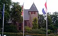
church building in Schermbeck, North-Rhine-Westphalia, Germany  | |||||
| Upload media | |||||
| Instance of | |||||
|---|---|---|---|---|---|
| Named after | |||||
| Location | Gahlen, Schermbeck, Wesel, Düsseldorf Government Region, North Rhine-Westphalia, Germany | ||||
| Heritage designation | |||||
 | |||||
Media in category "Gahlener Dorfkirche"
The following 5 files are in this category, out of 5 total.
-
 Gahlen – Ev. Dorfkirche aus dem 12. Jahrh. - panoramio.jpg 2,561 × 1,571; 1.12 MB
-
 Schermbeck Baudenkmal 01 Evangelische Dorfkirche Gahlen 2020-05-16-2.jpg 3,369 × 2,610; 3.24 MB
-
 Schermbeck Baudenkmal 01 Evangelische Dorfkirche Gahlen 2020-05-16-3.jpg 2,677 × 3,659; 2.83 MB
-
 Schermbeck Baudenkmal 01 Evangelische Dorfkirche Gahlen 2020-05-16-4.jpg 4,067 × 3,189; 3.43 MB
-
 Schermbeck Baudenkmal 01 Evangelische Dorfkirche Gahlen 2020-05-16.jpg 3,795 × 2,996; 3.26 MB


Categories:
- Churches in Schermbeck
- Cultural heritage monuments in Schermbeck
- Churches in Kirchenkreis Dinslaken
- Brick Gothic churches in Kreis Wesel
- 12th-century church towers in Regierungsbezirk Düsseldorf
- Romanesque church towers in Regierungsbezirk Düsseldorf
- 16th-century churches in Regierungsbezirk Düsseldorf
- Gothic churches in Regierungsbezirk Düsseldorf
- Brick Gothic churches in Regierungsbezirk Düsseldorf
- Pseudobasilicas in Regierungsbezirk Düsseldorf
- Two-nave churches in Regierungsbezirk Düsseldorf