Category:Garonne
둘러보기로 이동
검색으로 이동
river in southwest France and northern Spain  D'Garonne zu Toulouse  | |||||
| 미디어 올리기 | |||||
| 다음 종류에 속함 | |||||
|---|---|---|---|---|---|
| 위치 | |||||
| 길이 |
| ||||
| 물길이 끝나는 곳 |
| ||||
| Drainage basin | |||||
| 여기로 흐르는 지류들 |
| ||||
| 다음과 같다고 여겨짐 | Q24001048 | ||||
 | |||||
"Garonne" 분류에 속하는 미디어
다음은 이 분류에 속하는 파일 33개 가운데 33개입니다.
-
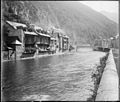
 (Bateaux lavoirs quai de Tounis) - Fonds Trutat - 51Fi248.jpg 900 × 657; 97 KB
-
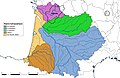 Adour-Garonne-regions-16.jpg 5,457 × 3,543; 1.1 MB
-
 Afsplitsing van het kanaal van de Neste..jpg 2,048 × 1,370; 871 KB
-
 Barrage d'Ausson.jpg 2,048 × 1,536; 909 KB
-
 Barsac - bords de la Garonne 10.jpg 1,000 × 635; 605 KB
-
 Berge Miramont de Comminges.png 787 × 420; 770 KB
-
 Boudou - Laurent Seignobos 3.jpg 4,352 × 2,904; 3.92 MB
-
 Boudou - Laurent Seignobos 4.jpg 4,352 × 2,904; 2.99 MB
-
 Capitainerie Brouage Tassin 16920.jpg 4,037 × 2,783; 9.72 MB
-
 Confluence Tarn Garonne 2023.jpg 9,353 × 2,098; 2.94 MB
-
 El Garona des del pont de Cledes - 20220814 095357.jpg 3,096 × 4,128; 3.21 MB
-
 El Garona des del pont de Cledes - 20220814 095414.jpg 3,096 × 4,128; 3.23 MB
-
 El Garona des del pont de Cledes - 20220814 095418.jpg 3,096 × 4,128; 3.19 MB
-
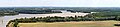
 Estuary of the Garonne River.jpg 4,031 × 2,587; 1.25 MB
-
 Fishermen's Huts, River Garonne, France (16090044505).jpg 3,626 × 2,372; 2.32 MB
-
 FontaineLouvois08.jpg 1,200 × 1,600; 1.24 MB
-
 Garonne au pont d'Empalot.jpg 3,968 × 2,976; 9.29 MB
-
 Garonne panneau.png 3,888 × 1,003; 2.6 MB
-

-
 Luchon , bords de la Garonne au pont de Chaum - Fonds Trutat - MHNT.PHa.89.L.151.jpg 7,396 × 6,301; 2.84 MB
-
 Maisons de village bordant une rivière (7063859423).jpg 554 × 211; 28 KB
-
 Miramont-de-Comminges Garonne kayak.jpg 4,527 × 3,356; 3.62 MB
-
 Nacemento rio garona.jpg 3,306 × 2,478; 1.43 MB
-
 Panneau Îlot de Saint-Cassian.jpg 5,312 × 2,992; 4.67 MB
-
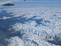 PicDuMidiDeBigorreColDuTourmalet.jpg 4,000 × 3,000; 4.5 MB
-

-
 Saint-Béat , bords de la Garonne - Fonds Trutat - MHNT.PHa.89.S.001.jpg 7,458 × 6,343; 2.49 MB
-
 Scouts Marins.jpg 1,252 × 939; 197 KB
-
 Source aranaise de la Garonne.jpg 1,440 × 2,560; 1.28 MB
-
 StBeatStBertrandDeComminges.jpg 4,000 × 3,000; 4.41 MB
-
 Via Garona - GR861.jpg 4,864 × 3,648; 3.38 MB
-
 Voyage entre deux mers - péniche Tourmente port de Bordeaux 23 mars 2022.jpg 4,128 × 2,322; 2.63 MB
-
Vue 3d du relief du Canton de Laplume et de la vallée de la Garonne Agenaise.ogv 52 s, 1,920 × 1,012; 30.14 MB
_-_Fonds_Trutat_-_51Fi248.jpg)


.jpg)


._-_panoramio.jpg)


_-_panoramio.jpg)


.jpg)