Category:Geographical playing cards
Jump to navigation
Jump to search
English: The tradition of printing engraved pictorial playing cards depicting educational, in particular geographical, subjects existed in Europe in the 18th-19th centuries. Among the examples are Boston de l'Univers ou Jeu des quatre parties du Monde (1825) by René Janet and Geographical and Astronomical card packs produced by Charles Hodges around 1827.
Subcategories
This category has the following 3 subcategories, out of 3 total.
Media in category "Geographical playing cards"
The following 9 files are in this category, out of 9 total.
-
 Geographicalgame039 (13382732294).jpg 1,844 × 1,307; 567 KB
-
 Jean-démosthène dugourc, gioco di carte rivoluzionario, 1792, 01.jpg 4,915 × 2,959; 7.67 MB
-
 Les tables de geographie, reduites en un jeu de cartes (35015059592).jpg 2,000 × 1,558; 3.36 MB
-
 Marco di pietro, gioco di carte per imparare la geografia, xviii secolo.jpg 3,723 × 3,381; 6.67 MB
-
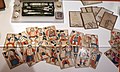
 Muzeum Diecezjalne - 11.JPG 3,072 × 2,304; 1.45 MB
-
 S. della Bella karcianka dla Ludwika XIV, XVII w.jpg 2,600 × 1,543; 1.86 MB
-
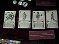
 Winstanley Geographical Cards - Europe.JPG 1,705 × 2,576; 1.86 MB
-
 Winstanley Geographical Cards - Iews.JPG 2,239 × 3,378; 2.89 MB
-
 Winstanley Geographical Cards - Polanders.JPG 1,705 × 2,568; 1.87 MB
.jpg)

.jpg)


