Category:Geography of Quebec
Naar navigatie springen
Naar zoeken springen
Provincies en territoria van Canada: Alberta · British Columbia · Manitoba · New Brunswick · Newfoundland and Labrador · Nova Scotia · Ontario · Prince Edward Island · Quebec · Saskatchewan · Northwest Territories · Nunavut · Yukon
Français : Géographie du Québec
geography of Quebec, Canada's largest province | |||||
| Media uploaden | |||||
| Is een |
| ||||
|---|---|---|---|---|---|
| Subklasse van | |||||
| Aspect van | |||||
| Locatie |
| ||||
| |||||
Ondercategorieën
Deze categorie bevat de volgende 20 subcategorieën, van de 20 in totaal.
*
B
C
G
I
L
M
P
S
W
Media in categorie "Geography of Quebec"
Deze categorie bevat de volgende 13 bestanden, van in totaal 13.
-
 2021-0818-11 Riviere Pentecote estuaire et quai.jpg 4.000 × 3.000; 4,81 MB
-
 2021-0818-12 Riviere Pentecote.jpg 4.000 × 3.000; 4,61 MB
-
 2021-0818-13 Riviere Pentecote presqu'ile.jpg 4.000 × 2.666; 5,15 MB
-
 Buies - Les comtés de Rimouski, de Matane et de Témiscouata, 1890.djvu 1.645 × 2.471, 110 pagina's; 4,09 MB
-
 Charlevoix Meteorite Crater.jpg 250 × 250; 36 kB
-
 Ecoregions quebec map.svg 1.630 × 2.000; 844 kB
-
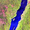
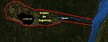 Graben Saguenay.jpg 997 × 393; 50 kB
-
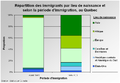 Immigration QC2.png 902 × 625; 62 kB
-
 Immigration QC3.png 902 × 625; 58 kB
-
 Population Québec 1851.jpg 805 × 579; 29 kB
-
 Saguenay Graben.jpg 997 × 393; 58 kB
-
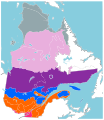 Zones vegetation Quebec 2.svg 920 × 1.061; 1,33 MB
-
 Zones vegetation Quebec.svg 920 × 1.061; 1,34 MB


