Category:Geotopes in Landkreis Lörrach
Jump to navigation
Jump to search
Urban districts (cities): Baden-Baden · Freiburg · Heidelberg · Heilbronn · Karlsruhe · Pforzheim · Stuttgart · Ulm
| NO WIKIDATA ID FOUND! Search for Geotopes in Landkreis Lörrach on Wikidata | |
| Upload media |
Subcategories
This category has the following 6 subcategories, out of 6 total.
E
I
N
- Nonnenmattweiher (22 F)
T
- Tschamberhöhle (5 F)
W
- Warmbach-Wasserfall (2 F)
- Wolfsschlucht (Kandern) (17 F)
Media in category "Geotopes in Landkreis Lörrach"
The following 17 files are in this category, out of 17 total.
-
 Atzenbacher Wasserfall 2019 2.jpg 7,952 × 5,304; 9 MB
-
 Efringen-Kirchen - Isteiner Rheinschwellen 02.JPG 5,472 × 3,080; 5.72 MB
-
 EichenerSee Lake Eichen 2013 04 24 P1050155.JPG 4,608 × 3,456; 8.3 MB
-
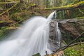
 Fischbach-Wasserfall Zell im Wiesental -2.jpg 1,365 × 1,365; 2.92 MB
-
 Grenzacher Hornfelsen.JPG 4,868 × 3,069; 6.67 MB
-
 Huttingen - Steinbruch Kapf1.jpg 11,768 × 4,472; 21.96 MB
-
 Häger Wasserfälle 1.JPG 2,448 × 3,264; 4.15 MB
-
 Nonnenmattweiher.jpg 2,048 × 1,536; 1.49 MB
-
 Rheinfelden (Baden) Naturschutzgebiet Buhrenboden Bild 9.jpg 5,472 × 3,648; 10.69 MB
-
 Schönau im Schwarzwald überbaute Gletscherschliff unter dem Schlageter-Denkmal.jpg 5,472 × 3,648; 9.17 MB
-
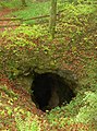 Teufelsloch Nordschwaben.JPG 1,704 × 2,304; 788 KB
-
 Todtnau Gletscherkessel Präg.jpg 6,495 × 2,902; 7.17 MB
-
 Todtnau Wasserfall Hauptstufe.jpg 1,728 × 3,072; 2.8 MB
-
 Todtnauer Wasserfall 2023-07-26 16-27.jpg 2,710 × 3,800; 3.36 MB
-
 Utzenfeld Todtnau Naturschutzgebiet Utzenfluh Bild 26.jpg 5,472 × 3,648; 12.92 MB
-
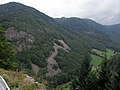 Zastler Tal mit Scheibenfelsen (links) 2.jpg 4,000 × 3,000; 5.14 MB
-
 Zell im Wiesental - Höll-Wasserfälle Bild 1.jpg 7,952 × 5,304; 27.04 MB


_Naturschutzgebiet_Buhrenboden_Bild_9.jpg)


_2.jpg)
