Category:Gittins Building, Neston
Jump to navigation
Jump to search
| Object location | | View all coordinates using: OpenStreetMap |
|---|
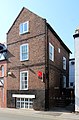
house in Neston, Cheshire West and Chester, Cheshire, UK  | |||||
| Upload media | |||||
| Instance of | |||||
|---|---|---|---|---|---|
| Location | Neston, Cheshire West and Chester, Cheshire, North West England, England | ||||
| Heritage designation |
| ||||
 | |||||
This is a category about listed building number 1387715. |
Grade II listed house, built 1744 and converted into a restaurant in the 20th century.
Media in category "Gittins Building, Neston"
The following 2 files are in this category, out of 2 total.
-
 Gittins Building, Neston 1.jpg 2,783 × 4,707; 10.82 MB
-
 Gittins Building, Neston 2.jpg 2,953 × 4,497; 7.83 MB
