Category:Glossop Line
Jump to navigation
Jump to search
railway line in England   | |||||
| Upload media | |||||
| Instance of | |||||
|---|---|---|---|---|---|
| Part of |
| ||||
| Location | East Midlands, England | ||||
| Owned by | |||||
| Operator | |||||
| |||||
Subcategories
This category has the following 14 subcategories, out of 14 total.
A
- Ashburys railway station (33 F)
B
- Broadbottom railway station (53 F)
D
- Dinting Viaduct (33 F)
F
- Flowery Field railway station (23 F)
G
- Glossop railway station (47 F)
- Godley East railway station (3 F)
- Godley railway station (22 F)
- Guide Bridge railway station (75 F)
H
- Hadfield railway station (25 F)
- Hattersley railway station (25 F)
M
N
- Newton for Hyde railway station (24 F)
Media in category "Glossop Line"
The following 17 files are in this category, out of 17 total.
-
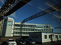
 Dinting Train approaching Piccadilly vista 5100.JPG 3,264 × 2,448; 2.55 MB
-
 Dinting Train approaching Piccadilly vista 5101.JPG 3,264 × 2,448; 2.66 MB
-
 Dinting Train vista 5098c.JPG 3,261 × 1,430; 725 KB
-
 Dinting Train vista on viaduct 5095.JPG 3,264 × 2,448; 2.59 MB
-
 Dinting Train vista on viaduct 5096.JPG 3,264 × 2,448; 2.56 MB
-
 Dinting Train vista on viaduct over Glossop chimney 5097.JPG 3,264 × 2,448; 2.32 MB
-
 Footbridge at Dinting Lane - geograph.org.uk - 3301907.jpg 640 × 480; 472 KB
-
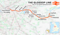 Glossop line.png 2,023 × 1,202; 2.37 MB
-
 Glossop Line.svg 1,207 × 543; 4.6 MB
-
 Johnson Brook Road - geograph.org.uk - 766307.jpg 640 × 480; 123 KB
-
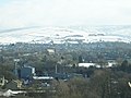
 Manchester to Glossop Railway Line - geograph.org.uk - 1282040.jpg 640 × 480; 135 KB
-
 Mottram Road, Godley.jpg 2,048 × 1,536; 982 KB
-
 Now closed level crossing at Higher Dinting - geograph.org.uk - 4124010.jpg 1,600 × 1,200; 611 KB
-
 Peak metals - geograph.org.uk - 3381902.jpg 4,031 × 2,663; 1.95 MB
-
 Stockport Road Bridge - geograph.org.uk - 18697.jpg 640 × 480; 107 KB
-
 The end of the line - geograph.org.uk - 3291761.jpg 800 × 533; 128 KB
-
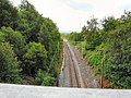 The line to Dinting - geograph.org.uk - 1378134.jpg 640 × 480; 136 KB


