Category:Granary in Chudów
Jump to navigation
Jump to search
| Object location | | View all coordinates using: OpenStreetMap |
|---|
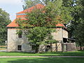
Polski: Chudów, ul. Wiejska - spichlerz dworski, z XVIII w., murowany
hambar in Chudów, Silesian Voivodeship, Poland  | |||||
| Upload media | |||||
| Instance of | |||||
|---|---|---|---|---|---|
| Location | Chudów, Gmina Gierałtowice, Gliwice County, Silesian Voivodeship, Poland | ||||
| Street address |
| ||||
| Heritage designation |
| ||||
| Inception |
| ||||
 | |||||
Media in category "Granary in Chudów"
The following 4 files are in this category, out of 4 total.
-
 Chudów, spichlerz dworski, elewacja wschodnia.JPG 4,000 × 3,000; 4.73 MB
-
 Chudów, spichlerz dworski, widok od pd-zach..JPG 4,000 × 3,000; 3.68 MB
-
 Chudów, spichlerz dworski, widok od pd..JPG 4,000 × 3,000; 4.9 MB
-
 Chudów, spichlerz dworski, widok od pn-wsch..JPG 4,000 × 3,000; 4.17 MB


