Category:Grosse Pierre (Verneusses)
Jump to navigation
Jump to search
|
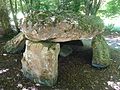
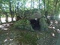
This building is classé au titre des monuments historiques de la France. It is indexed in the base Mérimée, a database of architectural heritage maintained by the French Ministry of Culture, under the reference PA00099614
|
| Object location | | View all coordinates using: OpenStreetMap |
|---|
 | |||||
| Upload media | |||||
| Instance of | |||||
|---|---|---|---|---|---|
| Made from material | |||||
| Location | Verneusses, canton of Broglie | ||||
| Street address |
| ||||
| Heritage designation |
| ||||
 | |||||
Media in category "Grosse Pierre (Verneusses)"
The following 10 files are in this category, out of 10 total.
-
 Dessin du dolmen de Verneusses par Coutil.jpg 1,272 × 715; 338 KB
-
 Dolmen de Verneusses 1.jpg 3,648 × 2,736; 4.09 MB
-
 Dolmen de Verneusses 2.jpg 3,648 × 2,736; 3.96 MB
-
 Dolmen de Verneusses 3.jpg 3,648 × 2,736; 4.09 MB
-
 Dolmen de Verneusses 4.jpg 3,648 × 2,736; 3.97 MB
-
 Dolmen de Verneusses 5.jpg 3,648 × 2,736; 4.1 MB
-
 Dolmen de Verneusses 8.jpg 3,648 × 2,736; 3.91 MB
-
 Redressement du dolmen de Verneusses.jpg 818 × 868; 320 KB
-
 Verneusses - Dolmen.JPG 3,417 × 2,241; 3.59 MB
-
 Vue en plan du dolmen de Verneusses par Coutil.jpg 928 × 603; 59 KB


