Category:Hinoemata, Fukushima
Vai alla navigazione
Vai alla ricerca
village in Minamiaizu district, Fukushima prefecture, Japan  | |||||
| Carica un file multimediale | |||||
| Istanza di | |||||
|---|---|---|---|---|---|
| Luogo |
| ||||
| Forma giuridica |
| ||||
| Data di fondazione o creazione |
| ||||
| Popolazione |
| ||||
| Superficie |
| ||||
| sito web ufficiale | |||||
 | |||||
Sottocategorie
Questa categoria contiene le 10 sottocategorie indicate di seguito, su un totale di 10.
File nella categoria "Hinoemata, Fukushima"
Questa categoria contiene 42 file, indicati di seguito, su un totale di 42.
-
 Hinoemata in Fukushima Prefecture Ja.svg 640 × 552; 16 KB
-
 Hinoemata in Fukushima Prefecture.png 1 281 × 901; 52 KB
-
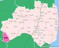 Location of Hinoemata village, Fukushima prefecture, Japan.svg 844 × 676; 25 KB
-
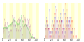 Population distribution of Hinoemata, Fukushima, Japan.svg 512 × 256; 21 KB
-
 Autumn and winter gradation (53301485432).jpg 6 604 × 4 403; 17,14 MB
-
 Autumn in Fukushima mountains (53302823015).jpg 6 900 × 4 600; 23,99 MB
-
 Big Tree - panoramio (5).jpg 2 736 × 3 648; 4,94 MB
-
 Buckwheat and Hactutou Sai, Japanese.jpg 4 000 × 3 000; 5,53 MB
-
 Chozo-goya, Fukushima 01.jpg 3 888 × 2 592; 2,74 MB
-
 Emblem of Hinoemata, Fukushima.svg 250 × 250; 1 KB
-
 Farm village Kabuki stage Hinoemata-no Butai.JPG 3 264 × 2 448; 4,15 MB
-
 Flag of Hinoemata Fukushima.JPG 367 × 227; 9 KB
-
 Flag of Hinoemata, Fukushima.svg 600 × 400; 718 byte
-
 Fukushima autumn valley (53302591923).jpg 7 008 × 4 672; 18,52 MB
-
 Fukushima autumn valley (53302823885).jpg 6 888 × 4 592; 18,59 MB
-
 Gunma Prefectural Road Route 001 & Fukushima Prefectural Road Route 001 001.jpg 2 388 × 1 387; 931 KB
-
 Hinoemata Fukushima chapter.JPG 192 × 177; 9 KB
-
 Hinoemata-Vill-Office.JPG 4 608 × 3 456; 7,3 MB
-

-

-

-
 Michinoeki Ozehinoemata (Alza Ozenosato).jpg 4 496 × 2 984; 4,91 MB
-
 Michinoeki Ozehinoemata (Ozenosato Interchange center).jpg 4 512 × 3 008; 8,8 MB
-
 Otsumata Dam lake survey 1976.jpg 947 × 714; 192 KB
-
 Oze-Numa Swamp Aerial Photograph.jpg 3 146 × 2 272; 1,96 MB
-
 Route 352, Hinoemata, Aizu - Aug 4, 2017.jpg 3 024 × 3 024; 5,17 MB
-
 Stairs - panoramio (1).jpg 2 736 × 3 648; 4,61 MB
-
 The Six Ksitigarbha(六地蔵) - panoramio.jpg 3 648 × 2 736; 4,73 MB
-
 The spring White Birch(春の白樺) - panoramio.jpg 2 736 × 3 648; 4,81 MB
-
 The Village's Landmark - panoramio.jpg 3 648 × 2 736; 4,96 MB
-
 The waterfall(滝) - panoramio.jpg 2 736 × 3 648; 4,74 MB
-
 Tomb with shop, way, and field(墓と道と店と畑) - panoramio.jpg 3 648 × 2 736; 4,12 MB
-
 ZZZ・・・ - panoramio.jpg 3 648 × 2 736; 4,65 MB
-
 オオシラビソの森を行く.jpg 4 896 × 3 672; 5,56 MB
-
 三岩岳.jpg 2 976 × 1 984; 2,73 MB
-
 尾瀬 桧枝岐村オートキャンプ場 - panoramio.jpg 3 872 × 2 592; 3,54 MB
-
 尾瀬桧枝岐村オートキャンプ場 - panoramio.jpg 3 872 × 2 592; 3,96 MB
-
 未丈ヶ岳.jpg 2 976 × 1 984; 2,04 MB
-
 毛猛山.jpg 2 976 × 1 984; 1,78 MB
-
 道の駅尾瀬檜枝岐.jpg 1 920 × 1 080; 409 KB
-
 酷道352号、新潟・福島県境、金泉橋 - panoramio.jpg 2 816 × 2 112; 2,76 MB
-
 馬坂峠登山口.jpg 4 896 × 3 672; 5,71 MB
.jpg)
.jpg)


.jpg)
.jpg)


.jpg)
_-_panoramio.jpg)
_-_panoramio.jpg)

_-_panoramio.jpg)


.jpg)
.jpg)
.jpg)
.jpg)
.jpg)