Category:Hof 6 (Alberschwende)
Jump to navigation
Jump to search
| Object location | | View all coordinates using: OpenStreetMap |
|---|
building in Alberschwende, Austria  | |||||
| Upload media | |||||
| Instance of | |||||
|---|---|---|---|---|---|
| Location | Alberschwende, Bregenz District, Vorarlberg, Austria | ||||
| Street address |
| ||||
| Heritage designation | |||||
 | |||||
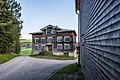
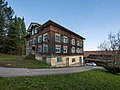
Deutsch: Vermutlich altes Mesnerhaus in Alberschwende Nr.6 im Bregenzerwald. Verschindelter, 5achsiger Würfelbau mit Zwerchgiebel, erbaut 1908.
Media in category "Hof 6 (Alberschwende)"
The following 4 files are in this category, out of 4 total.
-
 1908 Alberschwende Nr 6.JPG 3,873 × 2,343; 1.72 MB
-
 Hof 6, Alberschwende 1.JPG 2,500 × 1,668; 3.54 MB
-
 Hof 6, Alberschwende 2.JPG 2,500 × 1,667; 3.14 MB
-
 Hof 6, Alberschwende 3.JPG 2,500 × 1,875; 3.64 MB


