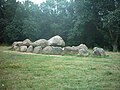
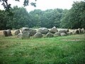
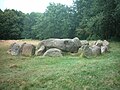
Category:Hunebed D20 in Drouwen
Jump to navigation
Jump to search
| Object location | | View all coordinates using: OpenStreetMap |
|---|
dolmen in the Netherlands  | |||||
| Upload media | |||||
| Instance of | |||||
|---|---|---|---|---|---|
| Part of | |||||
| Location | Drouwen, Borger-Odoorn, Drenthe, Netherlands | ||||
| Located on street |
| ||||
 | |||||
|
This is a category about rijksmonument number 464145
|
| Address |
|
Media in category "Hunebed D20 in Drouwen"
The following 24 files are in this category, out of 24 total.
-
 20170404 hunebedden D19 en D20 Drouwen1.jpg 3,573 × 1,080; 1.33 MB
-
 20170404 hunebedden D19 en D20 Drouwen2.jpg 3,881 × 1,080; 1.56 MB
-
 D19 en D20.JPG 2,272 × 1,704; 986 KB
-
 D20 kransstenen.JPG 2,272 × 1,704; 1.03 MB
-
 D20 poort.JPG 2,272 × 1,704; 1,024 KB
-
 Exterieur overzicht hunebedden D 19 en D 20 - Borger - 20321493 - RCE.jpg 1,184 × 1,200; 332 KB
-
 Exterieur overzicht hunebedden D 19 en D 20 - Drouwen - 20323019 - RCE.jpg 1,200 × 1,192; 361 KB
-
 Holwerda Hunebed D20 Plan.png 472 × 338; 94 KB
-
 Hunebed 012.jpg 640 × 480; 94 KB
-
 Hunebed 013.jpg 640 × 480; 104 KB
-
 Hunebed 014.jpg 640 × 480; 99 KB
-
 Hunebed D20 bij Drouwen.jpg 1,230 × 834; 215 KB
-
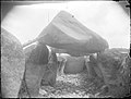 Hunebed D20 Excavation 01.jpg 2,000 × 1,513; 501 KB
-
 Hunebed D20 Excavation 02.jpg 2,000 × 1,510; 750 KB
-
 Hunebed D20 Excavation 03.jpg 2,000 × 1,509; 444 KB
-
 Hunebed D20 Excavation 04.jpg 2,000 × 1,509; 798 KB
-
 Hunebed D20 Excavation 05.jpg 2,000 × 1,504; 808 KB
-
 Hunebed D20 Excavation 06.jpg 2,000 × 1,503; 588 KB
-
 Hunebed D20 Excavation 07.jpg 2,000 × 1,500; 642 KB
-
 Hunebed D20 Excavation 08.jpg 2,000 × 1,500; 724 KB
-
 Hunebed D20 Excavation 09.jpg 2,000 × 1,500; 796 KB
-
 Hunebed D20 Excavation 10.jpg 2,000 × 1,503; 416 KB
-
 Hunebed D20 Excavation 11.jpg 2,000 × 1,496; 695 KB
-
 Hunebed D20 Goedeljee.jpg 2,000 × 1,551; 416 KB


