Category:June 2008 in Wales
Jump to navigation
Jump to search
English: Images taken in Wales in this month of 2008 (not the date of the upload).
| Jan | Feb | Mar | Apr | May | Jun | Jul | Aug | Sep | Oct | Nov | Dec | ||
| ← | 93 | 92 | 110 | 87 | 95 | 84 | 23 | 91 | 80 | 93 | 34 | 80 | → |
|---|
Subcategories
This category has the following 3 subcategories, out of 3 total.
Media in category "June 2008 in Wales"
The following 81 files are in this category, out of 81 total.
-
 "Ford" not a ford - geograph.org.uk - 844863.jpg 640 × 480; 62 KB
-
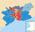 2008 Newport City Council election results map 01.png 828 × 768; 226 KB
-

-
 A crop of maize on Yr Allt Farm - geograph.org.uk - 836909.jpg 640 × 480; 75 KB
-
 A field of maize at Yr-allt Farm - geograph.org.uk - 841343.jpg 640 × 480; 72 KB
-

-
 A hayfield near Tyddyn Drain - geograph.org.uk - 841355.jpg 640 × 480; 62 KB
-

-
-
 Archway of St. John's Church, Rhos - geograph.org.uk - 830592.jpg 420 × 630; 147 KB
-
 Arriva NWW Dart SLF Pointer 1.jpg 1,462 × 1,016; 415 KB
-
 Arriva NWW Vario 1.jpg 1,006 × 751; 238 KB
-
 Borth Station - geograph.org.uk - 845240.jpg 640 × 422; 77 KB
-
 Bracelet Bay - geograph.org.uk - 865181.jpg 640 × 480; 99 KB
-
 Breton Street, Llandudno - geograph.org.uk - 863918.jpg 640 × 480; 201 KB
-
 Bronington - Bubney Moor woods - geograph.org.uk - 834519.jpg 640 × 480; 397 KB
-

-
 Bulmore Road - geograph.org.uk - 1758400.jpg 1,200 × 1,600; 465 KB
-
 Bungalows at Ravenspoint - geograph.org.uk - 867721.jpg 640 × 480; 46 KB
-
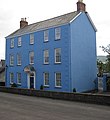 Castle Hill House, Monmouth - geograph.org.uk - 867925.jpg 588 × 640; 99 KB
-
 Chapel, Marsh Road A4066 , Pendine - geograph.org.uk - 943012.jpg 640 × 469; 73 KB
-
 Cineworld Multiplex Cinema - geograph.org.uk - 863242.jpg 640 × 480; 213 KB
-
 Conwy Castle - geograph.org.uk - 834877.jpg 640 × 480; 76 KB
-
 Conwy Modern Records Centre - geograph.org.uk - 863841.jpg 640 × 480; 192 KB
-
 Cottages in Porthmadog - geograph.org.uk - 865767.jpg 640 × 480; 186 KB
-

-
 Derry Ormond station - geograph.org.uk - 828098.jpg 640 × 410; 213 KB
-
 East Aberthaw Lagoon - geograph.org.uk - 848203.jpg 640 × 480; 89 KB
-
 GayDar (2607695703).jpg 510 × 779; 435 KB
-
 He's got it...^ - geograph.org.uk - 959313.jpg 640 × 480; 128 KB
-
 Head on (2608524140).jpg 513 × 778; 410 KB
-
 Holy Trinity Church, Llundudno - geograph.org.uk - 863521.jpg 480 × 640; 180 KB
-

-
 Llandimore, Gower - geograph.org.uk - 873549.jpg 640 × 480; 37 KB
-
 Llandudno Station - geograph.org.uk - 863434.jpg 640 × 480; 165 KB
-
 Lloyd Street West, Llandudno - geograph.org.uk - 864324.jpg 640 × 480; 196 KB
-

-
 Loughor Viaduct.JPG 3,072 × 2,304; 2.29 MB
-
 Low tide at Sarn Gynfelyn - geograph.org.uk - 845252.jpg 640 × 444; 78 KB
-
 Low tide at the beach of Llangrannog - geograph.org.uk - 917204.jpg 640 × 367; 69 KB
-
 Machynlleth Station - geograph.org.uk - 865780.jpg 640 × 480; 125 KB
-
 Machynlleth Station - geograph.org.uk - 865785.jpg 640 × 480; 153 KB
-
 Machynlleth Station yard - geograph.org.uk - 865793.jpg 640 × 480; 151 KB
-
 Machynlleth Yard - geograph.org.uk - 1037074.jpg 640 × 480; 192 KB
-
 Marina Tower June 08.JPG 2,592 × 3,888; 2.57 MB
-
 Merthyr Mawr Sand Dunes - geograph.org.uk - 838475.jpg 640 × 480; 334 KB
-
 Monmouth Castle.jpg 480 × 640; 172 KB
-
 Moorland north of Moel Llyn - geograph.org.uk - 836800.jpg 640 × 480; 155 KB
-
 Nant-y-moch reservoir - geograph.org.uk - 844702.jpg 640 × 428; 69 KB
-
 Nant-y-moch reservoir drying out - geograph.org.uk - 844691.jpg 640 × 428; 77 KB
-
 New Development - geograph.org.uk - 863862.jpg 480 × 640; 122 KB
-

-
 Pontcysyllte aqueduct arp (cropped).jpg 2,816 × 1,630; 3.16 MB
-
 Pontcysyllte aqueduct arp.jpg 2,816 × 2,078; 3.68 MB
-
 Port Eynon Bay.JPG 2,560 × 903; 869 KB
-
 Porthmadog link 3.jpg 640 × 480; 161 KB
-
 Porthmadog Station - geograph.org.uk - 865766.jpg 640 × 480; 182 KB
-
 Pwllcrochan from the north - geograph.org.uk - 842716.jpg 640 × 480; 103 KB
-
 Quakers Yard railway station in 2008.jpg 640 × 480; 95 KB
-
 Radyr Primary School.jpg 3,145 × 2,030; 1.01 MB
-
 Radyr Weir.JPG 3,648 × 2,736; 6.01 MB
-
 River Honddu - upstream of the bridge - geograph.org.uk - 853822.jpg 600 × 450; 286 KB
-
 River Tawe, near Glais - geograph.org.uk - 831198.jpg 640 × 480; 231 KB
-
 Rivers meet at Pontypridd - geograph.org.uk - 866012.jpg 640 × 480; 133 KB
-
 Sheepfold on Allt y Ddinas - geograph.org.uk - 830489.jpg 640 × 426; 71 KB
-

-
 Silver Lime Avenue - geograph.org.uk - 894438.jpg 640 × 480; 105 KB
-
 Taffs Well RFC.JPG 2,131 × 1,059; 1,003 KB
-

-
 The end of Sarn Gynfelyn - geograph.org.uk - 845257.jpg 640 × 437; 99 KB
-
 The End of the Pier - geograph.org.uk - 836767.jpg 640 × 480; 98 KB
-

-
 TraethYrOraSouth.jpg 861 × 646; 54 KB
-
 Treowen 01.jpg 1,447 × 983; 585 KB
-
 Treowen 02.jpg 1,500 × 1,000; 1.51 MB
-
 Treowen 03.jpg 1,462 × 1,000; 657 KB
-
 Upper Trevaughan - geograph.org.uk - 853579.jpg 640 × 480; 58 KB
-
 View to Wallog - geograph.org.uk - 845410.jpg 640 × 480; 127 KB
-
 Walking the dog - geograph.org.uk - 863452.jpg 640 × 480; 236 KB
-
 War Memorial - geograph.org.uk - 867614.jpg 640 × 480; 94 KB
-
 Yr Wyddfa o Y Garn.jpg 800 × 534; 61 KB


.jpg)

.jpg)


_a_small_chapel..._-_geograph.org.uk_-_846453.jpg)
.jpg)


