Category:Kaimai Range
Jump to navigation
Jump to search
mountains in New Zealand   | |||||
| Upload media | |||||
| Instance of | |||||
|---|---|---|---|---|---|
| Location |
| ||||
| Elevation above sea level |
| ||||
 | |||||
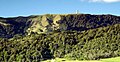
The Kaimai Range separates the Waikato and the Bay of Plenty regions of the North Island of New Zealand.
Subcategories
This category has the following 2 subcategories, out of 2 total.
W
- Wairere Falls (5 F)
Media in category "Kaimai Range"
The following 6 files are in this category, out of 6 total.
-
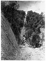 Butler’s Spur Incline on Waiorongomai Tramway (also known as Piako County Tramway).jpg 1,080 × 1,411; 202 KB
-
 Kaimai Ranges.jpg 1,536 × 1,024; 461 KB
-
 KaimaiPICT6700.jpg 998 × 515; 372 KB
-
 North Island NZ Kaimai Range.png 328 × 500; 40 KB
-
 Sunset over Kaimai Range from top of Mount Maunganui.jpg 4,500 × 2,520; 2.03 MB
-
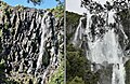 Wairere Falls in April 2010 and May 2023.jpg 2,391 × 1,564; 1.62 MB
.jpg)


