Category:Kerkstraat 24, Zaltbommel
Jump to navigation
Jump to search
| Object location | | View all coordinates using: OpenStreetMap |
|---|
building in Zaltbommel, Netherlands  | |||||
| Upload media | |||||
| Instance of | |||||
|---|---|---|---|---|---|
| Location | Zaltbommel, Gelderland, Netherlands | ||||
| Street address |
| ||||
| Heritage designation |
| ||||
 | |||||
|
This is a category about rijksmonument number 40204
|
| Address |
|
Media in category "Kerkstraat 24, Zaltbommel"
The following 5 files are in this category, out of 5 total.
-
 De Kerkstraat in Zaltbommel..jpg 4,770 × 3,177; 1.13 MB
-
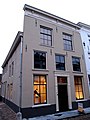 Kerkstraat 24.jpg 3,000 × 4,000; 787 KB
-
 Naar het noorden enz. voorgrond links de Ark - Zaltbommel - 20220419 - RCE.jpg 1,021 × 1,200; 235 KB
-
 Overzicht vanaf Heilige Geeststraat - Zaltbommel - 20220402 - RCE.jpg 999 × 1,200; 251 KB
-
 Zaltbommel, Netherlands - panoramio (19).jpg 2,048 × 1,148; 453 KB


.jpg)