Category:Khmelita estate
Jump to navigation
Jump to search
| Object location | | View all coordinates using: OpenStreetMap |
|---|
This is a category about a cultural heritage object in Russia, number: 6710068000
| |
| This template and pages using it are maintained by the Russian WLM team. Please read the guidelines before making any changes that can affect the monuments database! |
| Parent categories were assigned using the {{Category Russia}} template. In general, new categories should not be added by hand. The tree of categories is maintained automatically, any human edits may be overridden by bot. |
| This is the category of the protected area of Russia number 6710027 | |
| This template and pages using it are maintained by the Russian WLE team. Please read the guidelines before making any changes that can affect the database! |
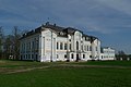
 Фасад усадебного дома, отреставрированный по проекту В. Е. Кулакова | |||||
| Upload media | |||||
| Instance of | |||||
|---|---|---|---|---|---|
| Location |
| ||||
| Heritage designation |
| ||||
| official website | |||||
 | |||||
Subcategories
This category has only the following subcategory.
K
- Viktor Yevgenievich Kulakov (7 F)
Media in category "Khmelita estate"
The following 54 files are in this category, out of 54 total.
-
 Elizabeth of Russia (Toque circle), 18th c, Khmelita.jpg 413 × 519; 86 KB
-
 I (3).jpg 1,680 × 1,120; 168 KB
-
 Khmelita manor rear facade.jpg 3,466 × 1,868; 998 KB
-
 Khmelita1.jpg 3,423 × 2,496; 1.71 MB
-
 RR5115-0057R.png 717 × 717; 627 KB
-
 Xmelita.jpg 1,147 × 768; 381 KB
-
 Вид из усадебного парка.jpg 5,616 × 3,744; 10.79 MB
-
 Галлерея между главным домом и юго-восточным флигелем усадьбы Хмелита.jpg 2,500 × 1,656; 2.12 MB
-
 Герб на фасаде.jpg 3,648 × 2,736; 2.93 MB
-
 Главный дом усадьбы Грибоедовых Хмелита.jpg 2,500 × 1,656; 2.86 MB
-
 Главный дом усадьбы Хмелита противоположная сторона.jpg 5,393 × 3,595; 10.16 MB
-
 Главный дом усадьбы Хмелита со стороны парадной лестницы.jpg 5,616 × 3,744; 12.94 MB
-
 Главный дом усадьбы Хмелита.jpg 2,500 × 1,656; 2.37 MB
-
 Гостиная усадьбы Грибоедова.jpg 3,648 × 2,736; 3.55 MB
-
 Дуб-долгожитель в Хмелите.jpg 3,456 × 4,608; 3.49 MB
-
 Дуб-памятник природы в Хмелите.jpg 3,456 × 4,608; 3.7 MB
-
 За алтарем церкви похоронен основатель и реставратор усадьбы Хмелита Кулаков В. Е.jpg 3,648 × 2,736; 4.15 MB
-
 За домом Казанская церковь.jpg 3,648 × 2,736; 4.04 MB
-
 Здание усадьбы со стороны главного входа.jpg 3,968 × 2,976; 2.78 MB
-
 Карта усадьбы.jpg 3,648 × 2,736; 3.67 MB
-
 Комната гусара.jpg 3,648 × 2,736; 2.52 MB
-
 Комната усадьбы в Хмелите.jpg 3,648 × 2,736; 3.38 MB
-
 Копия алмаза Шах.jpg 3,648 × 2,736; 2.8 MB
-
 Корпус служебный западный, карета перед зданием.jpg 3,648 × 2,736; 3.97 MB
-
 Красота усадебного парка.jpg 5,616 × 3,744; 11.8 MB
-
 Малоизведанный уголок усадьбы Хмелита.jpg 4,272 × 2,848; 4.97 MB
-
 Музей Хмелиты.jpg 3,648 × 2,736; 3.74 MB
-
 МУЗЕЙ-ЗАПОВЕДНИК «ХМЕЛИТА».jpg 1,225 × 816; 597 KB
-
 МУЗЕЙ-ЗАПОВЕДНИК А.С. ГРИБОЕДОВА «ХМЕЛИТА».jpg 1,225 × 816; 273 KB
-
 Музыкальный инструмент в усадьбе.jpg 3,648 × 2,736; 2.88 MB
-
 На празднике в Хмелите.jpg 3,648 × 2,736; 4.45 MB
-
 Парадный зал.jpg 3,648 × 2,736; 3.07 MB
-
 Парк музея-заповедника "Хмелита".jpg 1,225 × 816; 706 KB
-
 Платье крестьянки.jpg 2,736 × 3,648; 2.77 MB
-
 Портреты в усадьбе.jpg 3,648 × 2,736; 3.5 MB
-
 Праздник в Хмелите.jpg 3,648 × 2,736; 4.32 MB
-
 Пример исторической кладки усадьбы.jpg 2,976 × 3,968; 3.22 MB
-
 Пруд в усадебном парке.jpg 5,616 × 3,744; 9.5 MB
-
 Пруд в Хмелите.jpg 3,456 × 2,304; 2.54 MB
-
 Ремонт фасада.jpg 3,648 × 2,736; 4.37 MB
-
 Спальня усадьбы.jpg 3,648 × 2,736; 2.96 MB
-
 Табличка парадный зал.jpg 3,648 × 2,736; 3.55 MB
-
 Усадебный дом в Хмелите.jpg 4,608 × 3,456; 3.63 MB
-

-
 Усадьба Хмелита.jpg 3,776 × 2,520; 3.54 MB
-
 Фортепьяно в усадьбе.jpg 3,648 × 2,736; 3.33 MB
-
 Хмелита. Корпус служебный восточный.jpg 5,646 × 3,764; 2.3 MB
-
 Хмелита. Парк.jpg 6,000 × 4,000; 5.53 MB
-
 Хмелита. Пруд.jpg 5,858 × 3,935; 2.09 MB
-
 Хмелита. Флигель юго-западный.jpg 6,000 × 4,000; 2.06 MB
-
 Хмелита. Церковь Казанская.jpg 5,703 × 3,849; 2.13 MB
-
 Церковь Иконы Божией Матери Казанская (1759) в Хмелите.jpg 2,500 × 1,656; 2.71 MB
-
 Юго-восточный флигель усадьбы Хмелита.jpg 2,500 × 1,656; 2.57 MB
-
 Юго-западный флигель усадьбы Хмелита.jpg 2,500 × 1,656; 2.14 MB
,_18th_c,_Khmelita.jpg)
.jpg)


_%D0%B2_%D0%A5%D0%BC%D0%B5%D0%BB%D0%B8%D1%82%D0%B5.jpg)

