Category:Kimberley, Western Australia
Vai alla navigazione
Vai alla ricerca
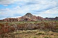
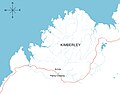
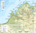
English: Kimberley is a region in the far north of Western Australia. The major towns are Broome and Kununurra.
administrative region of Western Australia    | |||||
| Carica un file multimediale | |||||
| Istanza di | |||||
|---|---|---|---|---|---|
| Prende il nome da | |||||
| Luogo | Australia Occidentale, Australia | ||||
| Popolazione |
| ||||
| Superficie |
| ||||
| sito web ufficiale | |||||
 | |||||
Sottocategorie
Questa categoria contiene le 48 sottocategorie indicate di seguito, su un totale di 48.
1
A
B
C
- Chamberlain River (2 F)
D
- Drysdale River National Park (4 F)
- Dunham River (1 F)
E
- Eighty Mile Beach (26 F)
- El Questro Wilderness Park (9 F)
F
- Fossil Downs Station (1 F)
G
- Geikie Gorge National Park (24 F)
- Gibb River Road (27 F)
- Goat Paddock crater (3 F)
- Gwion Gwion rock art (10 F)
H
- Hidden Valley National Park (1 P, 16 F)
- Horizontal Falls (3 F)
I
- Isdell River (2 F)
K
- King Edward River (2 F)
L
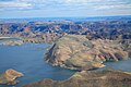
- Lake Argyle (41 F)
- Lennard River (3 F)
- Louisa Downs Station (5 F)
M
- Manning Gorge (9 F)
O
- Ord River (43 F)
P
- Pentecost River (6 F)
- Prince Regent National Park (10 F)
S
- Spider crater (4 F)
T
- Tunnel Creek National Park (13 F)
W
- Walsh Point, Mitchell Plateau (10 F)
- West Kimberley (2 F)
- Windjana Gorge National Park (30 F)
- Wunaamin Miliwundi Ranges (6 F)
- Wyndham, Western Australia (41 F)
Y
Pagine nella categoria "Kimberley, Western Australia"
Questa categoria contiene un'unica pagina, indicata di seguito.
W
File nella categoria "Kimberley, Western Australia"
Questa categoria contiene 20 file, indicati di seguito, su un totale di 20.
-
 .00 0848 Kimberley, Western Australia.jpg 3 900 × 2 600; 9,88 MB
-
 .00 0982 Ord River - Australia.jpg 3 600 × 2 400; 6,91 MB
-
 A Map of Bunuba Country.jpg 1 650 × 1 553; 226 KB
-

-

-
 Fitzroy Crossing, Kimberley Region of Western Australia.jpg 1 280 × 1 005; 139 KB
-
 Frigate bird - Flickr - photobom.jpg 3 556 × 2 570; 2,24 MB
-
 Kimberley region Australia.jpg 4 291 × 3 268; 6,66 MB
-
 Kimberley region of western australia.JPG 455 × 618; 42 KB
-
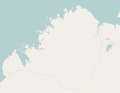
 Kimberley, Western Australia, LT.svg 749 × 683; 1,42 MB
-
 Kimberley.png 563 × 476; 31 KB
-
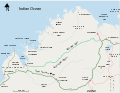
 Kimberleys, Western Australia - bare map.svg 2 129 × 1 654; 1,05 MB
-
 Kimberleys, Western Australia map, labelled.svg 1 030 × 800; 977 KB
-
 Location kimberley.png 329 × 352; 39 KB
-
 Makassan locations.jpg 728 × 488; 59 KB
-
 Somewhere near Fitzroy Crossing, Western Australia.jpg 3 543 × 3 543; 6,68 MB
-
 Western Australian Electoral Districts 1898 - Kimberley.png 2 191 × 1 816; 3,14 MB
-
 Zebra-Rock (GeoMuseum Cologne).JPG 2 355 × 2 285; 6,31 MB
-
 Zebra-Rock (GeoMuseum Cologne)2.JPG 2 796 × 2 252; 7,49 MB
-
 Zebra-Rock (GeoMuseum Cologne)3.JPG 2 623 × 2 013; 6,65 MB


.jpg)
.jpg)


.JPG)
2.JPG)
3.JPG)