Category:Kloster Wettenhausen
Jump to navigation
Jump to search
| Object location | | View all coordinates using: OpenStreetMap |
|---|
abbey   | |||||
| Upload media | |||||
| Instance of | |||||
|---|---|---|---|---|---|
| Location | Kammeltal, Günzburg, Swabia, Bavaria, Germany | ||||
| Street address |
| ||||
| Has part(s) |
| ||||
| Heritage designation | |||||
| Inception |
| ||||
| Dissolved, abolished or demolished date |
| ||||
| Religion or worldview | |||||
 | |||||
This is the category of the Bavarian Baudenkmal (cultural heritage monument) with the ID E-7-74-145-1 (Wikidata)
|
Subcategories
This category has the following 4 subcategories, out of 4 total.
Media in category "Kloster Wettenhausen"
The following 29 files are in this category, out of 29 total.
-
 Reichsstift Wettenhausen coat of arms.png 1,991 × 2,060; 33 KB
-
 Wappen Wettenhausen.png 800 × 828; 35 KB
-
 AK - Wettenhausen - Kloster - Erziehungsanstalt - 1907.jpg 1,042 × 1,375; 1.12 MB
-
 Deubach St. Martin 111.JPG 2,592 × 3,888; 8.47 MB
-
 Dionysius von Rehlingen2.jpg 892 × 1,480; 717 KB
-
 DEU Kammeltal COA.svg 512 × 547; 6 KB
-
 Wappen Kammeltal.png 116 × 131; 10 KB
-
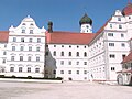
 Kammeltal - Wettenhausen - Angerweg - Kloster v SO.JPG 2,072 × 1,552; 1.94 MB
-
 Kammeltal - Wettenhausen - Kleinbeurer Weg Ri W.jpg 2,272 × 1,704; 1 MB
-
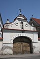
 Kammeltal - Wettenhausen - Klosterhof - Kapelle v O.jpg 2,272 × 1,704; 845 KB
-
 Kammeltal-Kammel mit Kloster Wettenhausen.jpg 3,497 × 1,967; 1.14 MB
-
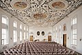 Kloster Wettenhausen - Kaisersaal.jpg 2,938 × 1,961; 3.41 MB
-
 Kloster Wettenhausen 2015.jpg 3,264 × 2,448; 781 KB
-
 Kloster wettenhausen.jpg 1,000 × 815; 86 KB
-
 Kloster Wettenhausen.jpg 4,056 × 3,022; 18.36 MB
-
 Klostergarten wettenhausen.jpg 760 × 677; 65 KB
-
 KreuzgangKlosterWettenhausen1.jpg 2,112 × 2,816; 2.18 MB
-
 Kui 098.JPG 2,816 × 2,112; 1.98 MB
-
 KupferstichAbteiWettenhausen.jpg 1,308 × 1,588; 372 KB
-
 Wappenbuch Circulus Suevicus 25.jpg 666 × 871; 283 KB
-
 Wettenhausen Kloster 132.JPG 3,888 × 2,592; 8.47 MB
-
 Wettenhausen Kloster 154.JPG 2,481 × 3,681; 6.63 MB
-
 Wettenhausen Kloster 155.JPG 2,198 × 3,674; 6.47 MB
-
 Wettenhausen Kloster Kreuzgang 133.JPG 2,570 × 3,821; 7.69 MB
-
 Wettenhausen Kloster Kreuzgang 134.JPG 3,888 × 2,592; 8.38 MB
-
 Wettenhausen Kloster Kreuzgang 137.JPG 2,488 × 3,686; 8.05 MB
-
 Wettenhausen Kloster Kreuzgang 144.JPG 2,592 × 3,888; 7.17 MB
-
 Wettenhausen Kloster Kreuzgang 145.JPG 2,592 × 3,888; 6.26 MB
-
 Wettenhausener Altar.jpg 4,592 × 3,056; 4.15 MB


Categories:
- Monasteries in Swabia (administrative region)
- Monasteries in Bavaria by municipality
- Religious buildings in Landkreis Günzburg
- Buildings in Kammeltal
- Imperial abbeys
- Monasteries of Augustinian Canons in Bavaria
- Monasteries established in 982
- Augustinian monasteries established in the 1130s
- Monasteries disestablished in 1803
- Dominican monasteries in Bavaria
- Villages in Landkreis Günzburg
- 982 establishments in Germany
- Cultural heritage monuments in Kammeltal
- Wettenhausen (Kammeltal)