Category:Kosa, Kumamoto
둘러보기로 이동
검색으로 이동
town in Kamimashiki district, Kumamoto prefecture, Japan   | |||||
| 미디어 올리기 | |||||
| 다음 종류에 속함 | |||||
|---|---|---|---|---|---|
| 위치 |
| ||||
| 법인격 |
| ||||
| 만들어진 날 |
| ||||
| 인구수 |
| ||||
| 면적 |
| ||||
| 다음에서 이어받음 |
| ||||
| 다음과 다름 | |||||
| 공식 웹사이트 | |||||
 | |||||

하위 분류
다음은 이 분류에 속하는 하위 분류 3개 가운데 3개입니다.
"Kosa, Kumamoto" 분류에 속하는 미디어
다음은 이 분류에 속하는 파일 15개 가운데 15개입니다.
-
 Emblem of Kōsa, Kumamoto.svg 142 × 110; 4 KB
-
 Flag of Kosa Kumamoto.JPG 204 × 145; 16 KB
-
 Flag of Kōsa, Kumamoto.svg 600 × 400; 880 바이트
-
 JA Kamimashiki.JPG 3,264 × 2,448; 1.89 MB
-
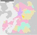 Kosa in Kumamoto Prefecture Ja.svg 527 × 497; 15 KB
-
 Kosa in Kumamoto Prefecture.png 981 × 901; 42 KB
-
 Kosa Kumamoto chapter.JPG 131 × 103; 16 KB
-
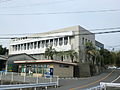
 Kosa Town Office 2012.JPG 1,684 × 1,263; 876 KB
-
 Kumamoto pref road 106.JPG 3,264 × 2,448; 1.66 MB
-
 Kumamoto pref road 239.JPG 3,264 × 2,448; 2.05 MB
-
 Kumamoto prefectural roads 106 Kosa-Mifune border.JPG 3,264 × 2,448; 1.81 MB
-
 Kumamoto prefectural roads 106 Mifune-Kosa border.JPG 3,264 × 2,448; 1.86 MB
-
 Kyushu Expwy Kosa-Jonan Border 2017.JPG 1,632 × 1,224; 689 KB
-
 Midorikawa PA East 2012.JPG 1,684 × 1,263; 784 KB
-
 Population distribution of Kosa, Kumamoto, Japan.svg 512 × 256; 22 KB


