Category:La Malbaie (Percé)
Jump to navigation
Jump to search
 | |||||
| Upload media | |||||
| Instance of | |||||
|---|---|---|---|---|---|
| Location | Percé, Le Rocher-Percé, Gaspésie–Îles-de-la-Madeleine, Quebec, Canada | ||||
 | |||||
Subcategories
This category has the following 10 subcategories, out of 10 total.
A
B
- Bridgeville, Percé (12 F)
C
- Cannes-de-Roches (20 F)
L
- La Belle Anse (5 F)
R
- Rivière du Portage (Percé) (37 F)
- Rivière Malbaie (Percé) (2 F)
S
T
Media in category "La Malbaie (Percé)"
The following 7 files are in this category, out of 7 total.
-
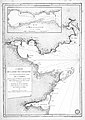 Carte de la baie des Chaleurs a la cote Occidentale du golfe de St. Laurent.jpg 2,472 × 3,496; 1.97 MB
-
 ISS059-E-113948 - View of the Province of Quebec.jpg 5,568 × 3,712; 2.09 MB
-
 La Malbaie vue du ciel.jpg 3,124 × 2,754; 2.31 MB
-
 Le hameau de Mal-Bay et une partie de la Baie de La Malbaie, comte Gaspe-Est.jpg 1,305 × 921; 447 KB
-
 Marsh Lands at the mouth of Malbaie River.jpg 2,152 × 2,604; 2.22 MB
-
 Plan de la rade de l Isle Percee.png 2,644 × 2,268; 10.6 MB
-
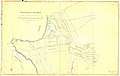 Township of Malbay - Blaiklock 1852.jpg 3,000 × 1,901; 1.24 MB


