Category:Landslide diagrams
Jump to navigation
Jump to search
Media in category "Landslide diagrams"
The following 21 files are in this category, out of 21 total.
-
 2006-05-23-120332 Iceland Eyvindarhólar ABC.jpg 660 × 447; 325 KB
-
 2010 Mount Meager landslide seismic signals.png 742 × 602; 264 KB
-
 Biostuoia.jpg 199 × 199; 17 KB
-
 Computer animation showing May 18, 1980 St Helens landslide.png 788 × 812; 217 KB
-
 Evolution of the Chiricahua Landscape.jpg 1,473 × 1,563; 449 KB
-
 GravityDrivenDeformation.jpg 507 × 639; 186 KB
-
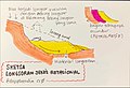
 Ilirskobistriski fosilni plaz podolzni prerez.jpg 3,110 × 1,275; 214 KB
-
 Le glissement de terrain et les solutions techniques.jpg 1,815 × 2,436; 1.12 MB
-
 Longsor-aliran-bahan-rombakan.jpg 3,159 × 2,336; 2.27 MB
-
 Longsor-rotasional.jpg 2,401 × 1,637; 419 KB
-
 Longsor-tekanan-pori.jpg 3,350 × 2,225; 1.48 MB
-
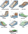 Major types of landslide movement.jpg 548 × 663; 192 KB
-
-
 Mount Meager landslide mass.jpg 452 × 402; 56 KB
-
 SchémaEboulementFrank1903.svg 512 × 358; 151 KB
-
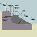
 Slopesyst.jpg 382 × 292; 19 KB
-
 Slopesyst2.jpg 433 × 286; 24 KB
-
 Urvina.jpg 300 × 300; 64 KB
-
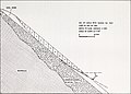
 Washington Landslide.png 1,098 × 412; 703 KB
-
 Yungay Viejo - location of landslide 1970.jpg 4,992 × 1,037; 1.71 MB
-
 Zosuv.png 1,052 × 744; 97 KB


_(20573505535).jpg)


