Category:Langestraat 36, Brielle
Jump to navigation
Jump to search
| Object location | | View all coordinates using: OpenStreetMap |
|---|
 | |||||
| Upload media | |||||
| Instance of | |||||
|---|---|---|---|---|---|
| Location | Brielle, Voorne aan Zee, South Holland, Netherlands | ||||
| Street address |
| ||||
| Located on street | |||||
| Heritage designation |
| ||||
 | |||||
|
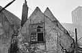
This is a category about rijksmonument number 10697
|
| Address |
|
Media in category "Langestraat 36, Brielle"
The following 13 files are in this category, out of 13 total.
-
 Brielle - rijksmonument 10697 - Langestraat 36 20111112.jpg 533 × 800; 237 KB
-
 Brielle 08.jpg 3,648 × 5,472; 16.73 MB
-
 Exterieur ACHTERGEVEL, KALF IN KOZIJN - Brielle - 20286799 - RCE.jpg 1,192 × 1,200; 284 KB
-
 Exterieur ACHTERGEVEL, KOZIJN - Brielle - 20286798 - RCE.jpg 1,200 × 1,192; 382 KB
-
 Exterieur ACHTERGEVEL, KOZIJN, KALF, DETAIL - Brielle - 20286800 - RCE.jpg 1,197 × 1,200; 274 KB
-
 Exterieur GEVELSTEEN - Brielle - 20309641 - RCE.jpg 1,200 × 795; 263 KB
-
 OVERZICHT - Brielle - 20266901 - RCE.jpg 1,200 × 961; 251 KB
-
 Overzicht evenzijde - Brielle - 20042905 - RCE.jpg 1,200 × 804; 177 KB
-
 Voorgevel - Brielle - 20042918 - RCE.jpg 795 × 1,200; 239 KB
-
 Zij- en achtergevel - Brielle - 20042919 - RCE.jpg 777 × 1,200; 193 KB
-
 Zij- en achtergevel - Brielle - 20042920 - RCE.jpg 1,200 × 780; 288 KB
-
 Zij- en achtergevel - Brielle - 20042921 - RCE.jpg 1,200 × 780; 183 KB
-
 Zijgevel aan het Raas - Brielle - 20042922 - RCE.jpg 1,200 × 800; 304 KB


