Category:Lillach-Quelle (Weißenohe)
Jump to navigation
Jump to search
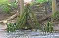
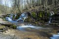
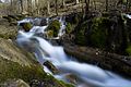
Deutsch: Die Lillach ist eine Schichtquelle im Landkreis Forchheim in Oberfranken in Bayern. Sie ist als Geotop (474Q004) und Naturdenkmal ausgewiesen.
Geotop in Landkreis Forchheim in Bavaria, Germany  | |||||
| Upload media | |||||
| Instance of | |||||
|---|---|---|---|---|---|
| Location | Gräfenberg, Forchheim, Upper Franconia, Bavaria, Germany | ||||
| Heritage designation | |||||
| Width |
| ||||
| Length |
| ||||
| Area |
| ||||
| Elevation above sea level |
| ||||
| official website | |||||
 | |||||
Media in category "Lillach-Quelle (Weißenohe)"
The following 12 files are in this category, out of 12 total.
-
 An der Lillachquelle 2.jpg 6,000 × 4,000; 12.15 MB
-
 An der Lillachquelle 3.jpg 6,000 × 4,000; 13.29 MB
-
 An der Lillachquelle 4.jpg 6,000 × 4,000; 9.6 MB
-
 An der Lillachquelle.jpg 6,000 × 4,000; 15.47 MB
-
 Die Quelle der Lillach, an Ostern geschmückt.jpg 2,954 × 1,937; 396 KB
-
 Lilachquelle Fest.JPG 2,877 × 2,068; 383 KB
-
 Lillachquelle - panoramio.jpg 1,024 × 768; 290 KB
-
 Lillachquelle 06.jpg 2,304 × 3,072; 3.81 MB
-
 Lillachquelle.JPG 2,816 × 2,112; 2.78 MB
-
 Lillachquellewaterfall.jpg 5,406 × 3,604; 13.06 MB
-
 Lillachquellewaterfallclose.jpg 6,000 × 4,000; 12.76 MB
-
 Lillachtal.jpg 1,080 × 1,080; 619 KB


Categories:
- Aubach (Schwabach)
- Geography of Weißenohe
- Geotopes in Landkreis Forchheim
- Landschaftsschutzgebiet Fränkische Schweiz - Veldensteiner Forst im Regierungsbezirk Oberfranken
- Natural monuments in Landkreis Forchheim
- FFH-Gebiet Lillinger Wald
- Protected areas in Naturpark Fränkische Schweiz-Veldensteiner Forst
- Geotopes in Naturpark Fränkische Schweiz-Veldensteiner Forst
- Bodies of water in Naturpark Fränkische Schweiz-Veldensteiner Forst
- Karst springs in Bavaria
- Springs of Upper Franconia
- Lillach