Category:Liverpool Bluecoat School chapel
Jump to navigation
Jump to search
| Camera location | | View all coordinates using: OpenStreetMap |
|---|
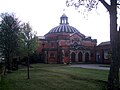
chapel in Wavertree, Liverpool, Merseyside, England, UK  | |||||
| Upload media | |||||
| Instance of | |||||
|---|---|---|---|---|---|
| Location | Wavertree, Liverpool, Merseyside, North West England, England | ||||
| Heritage designation |
| ||||
 | |||||
Media in category "Liverpool Bluecoat School chapel"
The following 4 files are in this category, out of 4 total.
-
 Bluecoat School chapel 1.jpg 4,792 × 3,416; 6.91 MB
-
 Bluecoat School chapel 2.jpg 4,512 × 3,408; 7.56 MB
-
 Bluecoat School, Wavertree - geograph.org.uk - 40909.jpg 640 × 480; 59 KB
-
 Chapel of Liverpool Bluecoat School.jpg 2,048 × 1,536; 356 KB


