Category:Locator maps of arrondissements of Finistère to 2016
Jump to navigation
Jump to search
Media in category "Locator maps of arrondissements of Finistère to 2016"
The following 17 files are in this category, out of 17 total.
-
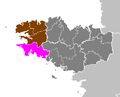
 Arrondissement de Brest.PNG 581 × 471; 15 KB
-
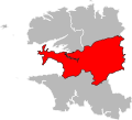
 Arrondissement de Châteaulin.PNG 581 × 471; 15 KB
-
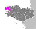
 Arrondissement de Morlaix.PNG 581 × 471; 15 KB
-
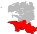
 Arrondissement de Quimper.PNG 581 × 471; 15 KB
-
 Arrondissement de Brest.png 418 × 314; 42 KB
-
 Arrondissement de Châteaulin.png 418 × 314; 42 KB
-
 Finistère - Brest arrondissement.svg 512 × 464; 16 KB
-
 Finistère - Châteaulin arrondissement.svg 512 × 464; 16 KB
-
 Finistère - Morlaix arrondissement.svg 512 × 464; 16 KB
-
 Finistère - Quimper arrondissement.svg 512 × 464; 16 KB
-
 Map arrondissement code 291.svg 504 × 442; 8 KB
-
 Map arrondissement code 292.svg 504 × 442; 8 KB
-
 Map arrondissement code 293.svg 504 × 442; 8 KB
-
 Map arrondissement code 294.svg 504 × 442; 8 KB
-
 Arrondissement de Morlaix.png 418 × 314; 42 KB
-
 Morlaix Limite administrative.png 954 × 577; 417 KB
-
 Arrondissement de Quimper.png 418 × 314; 42 KB


