Category:Maps of Bahr el Ghazal
Jump to navigation
Jump to search
Subcategories
This category has the following 4 subcategories, out of 4 total.
Media in category "Maps of Bahr el Ghazal"
The following 15 files are in this category, out of 15 total.
-
 SSudan-BAG.png 860 × 637; 19 KB
-
 1911French Congo.png 1,348 × 1,360; 1.98 MB
-

-
 Bahr el Ghazal in South Sudan 2015.svg 1,561 × 1,133; 229 KB
-
 Bahr el Ghazal Region.svg 422 × 315; 18 KB
-
 BahrElGhazal FrankLupton EGRavenstein 1884.jpg 1,151 × 1,600; 420 KB
-
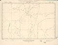 Deim Zubeir Sheet 77-B Jun 1917.jpg 2,923 × 2,271; 558 KB
-
 Deim Zubeir Sheet NB-35-B 1968.jpg 1,507 × 1,179; 249 KB
-
 Le Tour du monde-05-p395.png 820 × 567; 130 KB
-
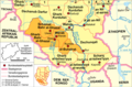 Sudan-karte-politisch-bahr-al-ghazal.png 624 × 411; 199 KB
-
 Gharb Bahr al-Ghazal Sudan map with districts2.svg 744 × 1,052; 155 KB
-
 Lakes Sudan map with districts2.svg 744 × 1,052; 155 KB
-
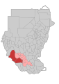
 Map Sudan Bahr el Ghazal.png 480 × 568; 150 KB
-
 Schamal Bahr al-Ghazal Sudan map with districts2.svg 744 × 1,052; 155 KB
-
 Warab Sudan map with districts2.svg 744 × 1,052; 155 KB


.jpg)