Category:Maps of Florissant Fossil Beds National Monument
Jump to navigation
Jump to search
US national monuments: Agate Fossil Beds · Aztec Ruins · Bandelier · Cabrillo · Canyon de Chelly · Cedar Breaks · Colorado · Craters of the Moon · Devils Postpile · Devils Tower · Dinosaur · Effigy Mounds · Florissant Fossil Beds · Gila Cliff Dwellings · Hovenweep · Jewel Cave · John Day Fossil Beds · Lava Beds · Little Bighorn Battlefield · Montezuma Castle · Muir Woods · Natural Bridges · Organ Pipe Cactus · Rainbow Bridge · Statue of Liberty · Sunset Crater Volcano · Timpanogos Cave · Walnut Canyon · Wupatki ·
English: Maps of Florissant Fossil Beds National Monument
Wikimedia category | |||||
| Upload media | |||||
| Instance of | |||||
|---|---|---|---|---|---|
| Category combines topics | |||||
| Florissant Fossil Beds National Monument | |||||
national monument in the United States  | |||||
| Instance of |
| ||||
| Location | Teller County, Colorado | ||||
| Visitor center | |||||
| Operator | |||||
| Heritage designation |
| ||||
| IUCN protected areas category | |||||
| Inception |
| ||||
| Area |
| ||||
| official website | |||||
 | |||||
Media in category "Maps of Florissant Fossil Beds National Monument"
The following 8 files are in this category, out of 8 total.
-
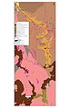 NPS florissant-fossil-beds-geologic-map.jpg 1,980 × 3,060; 469 KB
-
 NPS florissant-fossil-beds-geologic-map.pdf 1,650 × 2,550; 459 KB
-
 NPS florissant-fossil-beds-historic-map.jpg 2,000 × 1,250; 363 KB
-
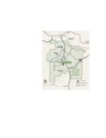
 NPS florissant-fossil-beds-map.jpg 984 × 1,225; 222 KB
-
 NPS florissant-fossil-beds-map.pdf 566 × 706; 745 KB
-
 NPS florissant-fossil-beds-trail-map.gif 970 × 1,166; 62 KB
-
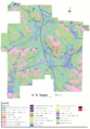 NPS florissant-fossil-beds-vegetation-map.gif 1,820 × 2,616; 434 KB
-
 NPS florissant-fossil-beds-visitor-center-map.gif 876 × 938; 41 KB


