Category:Markt 56, Steenwijk
Jump to navigation
Jump to search
| Object location | | View all coordinates using: OpenStreetMap |
|---|
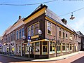
house in Steenwijkerland, Netherlands  | |||||
| Upload media | |||||
| Instance of | |||||
|---|---|---|---|---|---|
| Location | Steenwijk, Overijssel, Netherlands | ||||
| Street address |
| ||||
| Located on street |
| ||||
| Heritage designation |
| ||||
 | |||||
|
This is a category about rijksmonument number 34585
|
| Address |
|
Media in category "Markt 56, Steenwijk"
The following 4 files are in this category, out of 4 total.
-
 Markt 52 Steenwijk.jpg 3,648 × 2,736; 926 KB
-
 Markt 56 en58 Steenwijk.jpg 2,976 × 2,648; 622 KB
-
 Overzicht - Steenwijk - 20205594 - RCE.jpg 1,200 × 804; 146 KB
-
 Voorgevels - Steenwijk - 20205605 - RCE.jpg 803 × 1,200; 170 KB


