Category:Maug Islands
Vai alla navigazione
Vai alla ricerca
group of three small uninhabited islands   | |||||
| Carica un file multimediale | |||||
| Istanza di |
| ||||
|---|---|---|---|---|---|
| Parte di | |||||
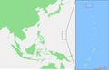
| Luogo | Isole Marianne Settentrionali | ||||
| Situato sul mare / lago / fiume | |||||
| Superficie |
| ||||
| Altezza sul mare |
| ||||
 | |||||
File nella categoria "Maug Islands"
Questa categoria contiene 32 file, indicati di seguito, su un totale di 32.
-
 Mariana Islands - Maug Islands.PNG 829 × 538; 26 KB
-
 Maug 3d hires.jpg 3 044 × 2 293; 2,32 MB
-
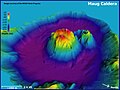
 Maug caldera bathymetry.jpg 3 693 × 2 250; 673 KB
-
 Maug East Island.jpg 3 456 × 2 304; 3,38 MB
-
 Maug Island - as seen from Navy P-3 cockpit - Spring 1988.jpg 4 159 × 2 889; 3,21 MB
-
 Maug Island - as seen from Navy P-3 cockpit on SAR mission - 1988.jpg 4 148 × 2 889; 2,7 MB
-
 Maug Island - as seen from Navy P-3 cockpit on SAR mission - early Spring 1988.jpg 4 118 × 2 913; 2,67 MB
-
 Maug Island - as seen from Navy P-3 cockpit on SAR mission - Spring 1988.jpg 4 144 × 2 890; 2,45 MB
-
 Maug Island - as seen from Navy P-3 cockpit on SAR mission.jpg 4 203 × 2 851; 2,73 MB
-
 Maug Island - as seen from P-3 cockpit on SAR mission - Spring 1988.jpg 4 181 × 2 866; 2,81 MB
-
 Maug Island - caldera looking south - Spring 1988.jpg 4 140 × 2 890; 3,28 MB
-
 Maug Island - central caldera as seen from Navy P-3 cockpit on SAR mission - Spring 1988.jpg 4 144 × 2 901; 2,83 MB
-
 Maug Island - crossing the threshold of the inner crater - Spring 1988.jpg 4 213 × 2 851; 1,78 MB
-
 Maug Island - flying just outside the rim of the caldera - Spring 1988.jpg 4 152 × 2 890; 2,69 MB
-
 Maug Island - gorgeous day for a SAR mission - Spring 1988.jpg 4 213 × 2 851; 2,51 MB
-
 Maug Island - Hazy weather with strong winds and some seaspray - Spring 1988.jpg 4 166 × 2 871; 1,98 MB
-
 Maug Island - headed for the gap - Spring 1988.jpg 4 213 × 2 851; 2,16 MB
-

-
 Maug Island - isolated, uninhabited and gorgeous - Spring 1988.jpg 4 148 × 2 900; 3,27 MB
-
 Maug Island - Japanese fishing boat all by himself - Spring 1988.jpg 4 057 × 2 956; 1,92 MB
-
 Maug Island - lining up to enter the central caldera - Spring 1988.jpg 4 141 × 2 901; 1,88 MB
-
 Maug Island - on SAR - Fam flight mission - Spring 1988.jpg 4 136 × 2 911; 2,23 MB
-
 Maug Island - over much deeper water outside the crater - Spring 1988.jpg 4 144 × 2 890; 2,64 MB
-
 Maug Island - Spring 1988.jpg 4 144 × 2 901; 3,05 MB
-
 Maug Island - water is much shallower within the crater - Spring 1988.jpg 4 197 × 2 851; 2,4 MB
-
 Maug Island and fishing boat - Spring 1988.jpg 4 215 × 2 840; 2,79 MB
-
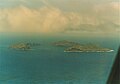
 Maug Islands Aerial.JPG 432 × 283; 29 KB
-
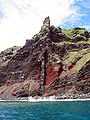 Maug islands dike.jpg 1 688 × 2 250; 1 MB
-
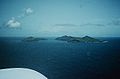
 Maug islands.jpg 640 × 417; 27 KB
-
 Maug.png 339 × 351; 224 KB
-
 NASA-MaugIslands.jpg 1 280 × 800; 90 KB
-
 Thompson maug hirez.jpg 3 000 × 2 250; 1,14 MB


Categorie:
- Islands of the Northern Mariana Islands
- Northern Islands Municipality
- Volcanoes in the Northern Mariana Islands
- Stratovolcanoes in the Northern Mariana Islands
- Partially submerged calderas
- Partially submarine volcanoes in the Pacific Ocean
- Partially submarine volcanoes in the United States
- Calderas in the Northern Mariana Islands
- Uninhabited islands of the United States