Category:Molenweg 35, Laren
Jump to navigation
Jump to search
| Object location | | View all coordinates using: OpenStreetMap |
|---|
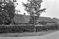
farmhouse in Laren, Netherlands  | |||||
| Upload media | |||||
| Instance of | |||||
|---|---|---|---|---|---|
| Location | Laren, North Holland, Netherlands | ||||
| Street address |
| ||||
| Heritage designation |
| ||||
 | |||||
|
This is a category about rijksmonument number 23948
|
| Address |
|
Media in category "Molenweg 35, Laren"
The following 2 files are in this category, out of 2 total.
-
 Gevel - Laren - 20129233 - RCE.jpg 1,200 × 800; 217 KB
-
 Laren Molenweg 35.jpg 3,534 × 2,622; 6.11 MB
