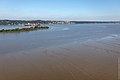
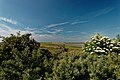
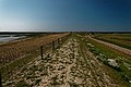
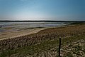
Category:Mudflats
Aller à la navigation
Aller à la recherche
Deutsch: Watt ist eine Küstenform
English: Mudflats are a type of coast
日本語: 泥質干潟
한국어: 개펄
zone côtière à sol vaseux  | |||||
| Téléverser des médias | |||||
| Sous-classe de |
| ||||
|---|---|---|---|---|---|
| Matériau | |||||
| Lieu | parc naturel marin du bassin d'Arcachon | ||||
| Réputé identique à | Osucha | ||||
| |||||
Sous-catégories
Cette catégorie comprend 13 sous-catégories, dont les 13 ci-dessous.
+
- Mudflat diagrams (3 F)
.
- Mudflat carriages (21 F)
A
- Arenicola marina (130 F)
K
- Kreier (13 F)
M
- Mudflats in lagoons (1 F)
R
- Ripples at mudflats (2 F)
T
Média dans la catégorie « Mudflats »
Cette catégorie comprend 113 fichiers, dont les 113 ci-dessous.
-
De-Watt.ogg 1,4 s ; 15 kio
-
De-Wattenmeer.ogg 1,7 s ; 17 kio
-
 A brittle star flipping itself rightside-up.jpg 1 280 × 853 ; 607 kio
-
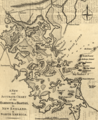 A new and accurate chart of the harbour of Boston in New England in North America (1782).tif 1 600 × 1 956 ; 11,94 Mio
-
 A5h006 8mp Falls of Ohio mud flats (6418174181).jpg 3 527 × 2 373 ; 3,59 Mio
-
Azraq flooding May 2023.webm 18 s, 640 × 360 ; 992 kio
-
 Russ' Island, showing boats, beach, cottages, &c (NYPL b12535909-G90F235 062ZF).tiff 3 072 × 1 897 ; 16,68 Mio
-

-
 Bancao Beach Brittle Star flipping itself rightside-up.jpg 1 280 × 853 ; 376 kio
-
 Bancao Beach Brittle Star rightside-up.jpg 1 280 × 853 ; 484 kio
-
 Bandon marsh national wildlife refuge.jpg 1 050 × 840 ; 95 kio
-
 Brewster mudflat.jpg 1 600 × 1 200 ; 1,14 Mio
-
 Calidris alpina waddensea.jpg 640 × 434 ; 193 kio
-
 Cape Henlopen tidal flat.jpg 6 744 × 1 374 ; 1,52 Mio
-
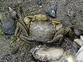
 Crabs On Mudflat (2140697697).jpg 3 008 × 2 000 ; 3,21 Mio
-
 Dead Trees and Mudflat at Low Tide (15735879971).jpg 3 474 × 2 601 ; 7,17 Mio
-
 Dongosaro AKK Reef Flats.jpg 500 × 340 ; 41 kio
-
 Ecomare - diatomeeënmat (diatomeeenmat-2095-ogb).jpg 2 592 × 1 944 ; 2,15 Mio
-
 Estuary - panoramio (1).jpg 3 264 × 2 448 ; 895 kio
-
 Excited egrets (6518324127).jpg 2 304 × 1 536 ; 913 kio
-
 Fiddler Crab on barnacle.jpg 3 648 × 2 736 ; 2,94 Mio
-
 Flooded mudflat at Azraq.png 1 982 × 1 126 ; 2,85 Mio
-
 France - Passage du Gois - pêche à pied.jpg 2 048 × 1 536 ; 1,24 Mio
-
 Gibraltar Point.jpg 640 × 480 ; 143 kio
-
 Grand fort philippe vasière algues.jpg 945 × 682 ; 452 kio
-
 Guide leaflet (1901) (14581623548).jpg 2 926 × 4 762 ; 1,3 Mio
-
 Haematopus ostralegus3.jpg 403 × 212 ; 74 kio
-
 Helice tridens (Kohnoura) 2.jpg 640 × 480 ; 301 kio
-
 Helice tridens (Kohnoura).jpg 640 × 480 ; 118 kio
-
 Hemiscyllium ocellatum (Epaulette shark) at Heron Island, Queensland.png 4 261 × 3 272 ; 22,05 Mio
-
 Isolation.jpg 1 024 × 768 ; 144 kio
-
 Kometsukigani 06g0139v.jpg 600 × 600 ; 146 kio
-
 Krabbenfischer auf dem Watt (1894-95) - Wd b132.jpg 2 368 × 1 552 ; 1,92 Mio
-
 Lick auf die Wattflächen und den Vorlandschutz an der Elbe bei Otterndorf (52084586006).jpg 3 000 × 1 999 ; 6,18 Mio
-
 Line5120 - Flickr - NOAA Photo Library.jpg 3 008 × 2 000 ; 946 kio
-
 Looking across Tacoma Tideflats, 1898 (WASTATE 2351).jpeg 768 × 547 ; 41 kio
-

-
 Marazion, St. Michael's Mount - geograph.org.uk - 211008.jpg 640 × 480 ; 111 kio
-
 Mataiva2.jpg 3 118 × 2 078 ; 416 kio
-
 Melaka-mud-flats-N-of-Pulau-Melaka-2233.jpg 2 048 × 1 536 ; 1,58 Mio
-
 Merir AKK Reef Flats.jpg 500 × 340 ; 72 kio
-
 Montague Harbour Marine Provincial Marine Park, tidal lagoon with view of Mt. Sutil.jpg 1 600 × 1 200 ; 689 kio
-
 Moran Homecoming NY Harbour.jpg 792 × 526 ; 242 kio
-
 Mudflat (40468169112).jpg 15 143 × 5 475 ; 41,28 Mio
-
 Mudflat and clouds in Sundarbans.jpg 800 × 532 ; 115 kio
-
 Mudflat at Low Tide with Santubong Peninsula in the background (15735828941).jpg 4 000 × 3 000 ; 7,84 Mio
-
 Mudflat channel. Kincaid Park, Alaska (5429390922).jpg 2 579 × 3 868 ; 6,05 Mio
-
 Mudflat experience in Daebudo.jpg 2 560 × 1 920 ; 1,51 Mio
-
 Mudflat transport.jpg 988 × 643 ; 52 kio
-
 Mudflats left behind by a receding tide at Bombay Hook National Wildlife Refuge.jpg 2 048 × 1 362 ; 868 kio
-
 Mudflats on Conwy river at dusk - geograph.org.uk - 118215.jpg 640 × 480 ; 202 kio
-
 Mudflats-polariser-1.jpg 3 008 × 2 000 ; 2,43 Mio
-
 Mudflats-polariser-2.jpg 3 008 × 2 000 ; 2,24 Mio
-
 Museum fg05.jpg 800 × 512 ; 286 kio
-
 NB - Daniels Flat (Bay of Fundy).jpg 2 523 × 1 422 ; 1 023 kio
-
 Priele und Wattflächen des Mühlenberger Lochs an der Elbe bei Hamburg (52083429922).jpg 3 000 × 1 999 ; 4,02 Mio
-
 Priele und Wattflächen des Mühlenberger Lochs an der Elbe bei Hamburg (52084705814).jpg 3 000 × 1 999 ; 4,77 Mio
-

-

-
 RockpilesAtTheSouthEndOfSolanaBeach-CA.jpg 1 800 × 1 350 ; 1,02 Mio
-
 Rocky Outcrops and Mudflat at Low Tide (15737772085).jpg 4 000 × 3 000 ; 8,72 Mio
-
 SEAWARD mangrove migration.jpg 817 × 505 ; 119 kio
-
 Spartina anglica.jpg 1 500 × 999 ; 750 kio
-
 Stone Hulks Mersea Island.jpg 640 × 480 ; 82 kio
-

-
 Takutea AKK Reef Flats.jpg 500 × 340 ; 41 kio
-
 Texel - De Hors - Footpath near Stuifdijk - View NNW towards De Mok & Den Hoorn.jpg 5 932 × 3 954 ; 21,98 Mio
-
 Texel - Mokbaai Dijk - Molwerk - View WNW.jpg 5 856 × 3 904 ; 22,15 Mio
-
 Texel - Mokbaai Dijk - View South on De Mok.jpg 6 048 × 4 032 ; 24,32 Mio
-
 Texel - Mokbaai Dijk - View SW on De Mok.jpg 5 992 × 3 994 ; 22,79 Mio
-
 Texel - Mokbaai Dijk - View West on De Mok.jpg 5 890 × 3 926 ; 22,69 Mio
-
 Texel - Mokbaai Dike - ICE Photocompilation Viewing from ESE to WNW on De Mok.jpg 7 095 × 2 155 ; 16,76 Mio
-
 Texel - Mokbaai Dike - View SSE on De Mok.jpg 6 048 × 4 032 ; 24 Mio
-
 Texel - Mokbaai Dike - View SSW on De Mok - The Dike has recently been heightened.jpg 5 992 × 3 994 ; 22,85 Mio
-
 Texel - Mokbaai Dike - View WNW.jpg 6 040 × 4 026 ; 23,1 Mio
-
 Texel - Mokbaai Dike - View WSW on De Mok II.jpg 5 902 × 3 934 ; 22,01 Mio
-
 Texel - Molwerk - Mokbaai Dijk - ICE 360° panorama of De Mok, De Petten & Het Lage Land 03.jpg 12 288 × 2 297 ; 31,76 Mio
-
 Texel - Molwerk - Mokbaai Dijk - ICE 360° panorama of De Mok, De Petten & Het Lage Land 04.jpg 12 288 × 2 200 ; 30,33 Mio
-
 Texel - Molwerk - Mokbaai Dijk - View ESE.jpg 5 992 × 3 994 ; 23,28 Mio
-
 Texel - Molwerk - Mokbaai Dike - View ESE.jpg 5 992 × 3 994 ; 23,39 Mio
-
 The mudflats in Turnagain Arm at low tide (IMG 1189a) (3587499039).jpg 3 427 × 2 140 ; 1,07 Mio
-
 Thixotropie.JPG 2 048 × 1 536 ; 1,26 Mio
-
 Tidal flat closeup.jpg 640 × 480 ; 334 kio
-
 Tidal Flats from above. (17207941857).jpg 2 400 × 1 397 ; 4,03 Mio
-
 Tidal flats Wadden sea.JPG 2 592 × 1 944 ; 1,35 Mio
-
 Tidal flats.jpg 640 × 480 ; 257 kio
-
 Tidal Indicator Delaware River ca1897.jpg 800 × 827 ; 199 kio
-
 Tidal mudflats near Inchmery House, Lower Exbury - geograph.org.uk - 33289.jpg 640 × 480 ; 154 kio
-
 Tufts of grass at the edge of mudflats.jpg 4 864 × 3 648 ; 17,35 Mio
-
 View of Harbor Island, ca 1912 (MOHAI 6276).jpg 700 × 572 ; 51 kio
-
 View over Nelson and Boulder Bank.jpg 1 024 × 768 ; 295 kio
-
 Waikaraka Cycleway from Mangere Bridge III.jpg 1 600 × 1 200 ; 1,28 Mio
-
 Waikaraka Cycleway from Mangere Bridge IV.jpg 1 600 × 1 200 ; 1,03 Mio
-
 Waiting for ebb at Kuala Lumpur.jpg 4 608 × 2 140 ; 3,41 Mio
-
 Walking in the sea, Southport, UK (6432329791).jpg 2 572 × 3 445 ; 5,04 Mio
-
 Waterfront and tidal flats from Beacon Hill, ca 1898 (MOHAI 5851).jpg 700 × 545 ; 46 kio
-
 Wattboden.JPG 1 575 × 1 655 ; 535 kio
-
 Wattflächen des Mühlenberger Lochs an der Elbe bei Hamburg (52083433622).jpg 3 000 × 1 999 ; 5,57 Mio
-
 Wattflächen des Mühlenberger Lochs an der Elbe bei Hamburg (52084462041).jpg 3 000 × 1 999 ; 5,23 Mio
-
 Wattflächen des Mühlenberger Lochs an der Elbe bei Hamburg (52084465051).jpg 3 000 × 1 999 ; 5,1 Mio
-
 Wattflächen des Mühlenberger Lochs an der Elbe bei Hamburg (52084486868).jpg 3 000 × 1 999 ; 4,69 Mio
-
 Wattflächen des Mühlenberger Lochs an der Elbe bei Hamburg (52084705964).jpg 3 000 × 1 999 ; 6,04 Mio
-
 Wattflächen des Mühlenberger Lochs an der Elbe bei Hamburg (52084706189).jpg 3 000 × 1 296 ; 2,88 Mio
-
 Wattflächen des Mühlenberger Lochs an der Elbe bei Hamburg (52084960105).jpg 3 000 × 1 999 ; 5,93 Mio
-
 Wattflächen des Mühlenberger Lochs an der Elbe bei Hamburg (52084960190).jpg 3 000 × 1 999 ; 5,94 Mio
-
 Wattflächen des Mühlenberger Lochs an der Elbe bei Hamburg (52084960355).jpg 3 000 × 1 999 ; 4,67 Mio
-
 Wattflächen des Mühlenberger Lochs an der Elbe bei Hamburg (52084963875).jpg 3 000 × 1 999 ; 5,29 Mio
-
 Wattflächen des Mühlenberger Lochs an der Elbe bei Hamburg (52084964905).jpg 3 000 × 1 999 ; 5,46 Mio
-
 Wd b172.JPG 1 477 × 2 033 ; 1,5 Mio
-
 Wet Sand.jpg 2 592 × 1 944 ; 2,05 Mio
-
 Winter sunset over the Kincaid beach. Kincaid Park, Alaska (5521627592).jpg 1 440 × 720 ; 586 kio
-
 Xiaohao Beach, Xiapu 20230827.jpg 8 328 × 3 218 ; 19,37 Mio
-
 蕪崎img390.jpg 2 474 × 3 500 ; 913 kio

.jpg)


.jpg)
.jpg)

.jpg)
.jpg)
.jpg)


_(14581623548).jpg)

_2.jpg)
.jpg)
_at_Heron_Island,_Queensland.png)


_-_Wd_b132.jpg)
.jpg)

.jpeg)
.jpg)


.jpg)
.jpg)


.jpg)
.jpg)
.jpg)
.jpeg)
.jpeg)

.jpg)


.jpeg)


_(3587499039).jpg)


.jpg)


.jpg)


.jpg)

.jpg)
.jpg)
.jpg)
.jpg)
.jpg)
.jpg)
.jpg)
.jpg)
.jpg)
.jpg)
.jpg)


.jpg)

.jpg)
.jpg)