Category:Nakanojō, Gunma
Motivo: Japanese place names, including municipalities, are officially spelt without macrons; see the Gazetteer of Japan, #2257 provided by the Geospatial Information Authority of Japan
Data: inserito il 27 gennaio 2024.
Objections and discussion have their place at Category talk:Nakanojō, Gunma (two weeks are considered as adequate time for possible objections). See Commons:Rename a category for general information and policy.
- Dopo aver raggiunto un chiaro consenso in $page (o dopo due settimane se non ci sono obiezioni), per favore rimuovi questo avviso sostituendolo con {{category redirect|Nakanojo, Gunma}} o richiedendo ulteriore aiuto in Category talk:Requested moves (se necessario).
- If the proposal is clearly or potentially controversial or requires a broader discussion, you can transfer the discussion to Commons:Categorie in discussione (replacing this template with {{subst:cfd}})
- If the proposal is clearly nonsensical, mistaken or consensually rejected, please remove this template.
Warning: processing period depends on activity of Commons volunteers. Some proposals (especially with unclear reason or too weak support) stay waiting for many months to be handled.
Comando per la sostituzione automatica via bot (solo admin): {{move cat|Nakanojō, Gunma|Nakanojo, Gunma|reason=Japanese place names, including municipalities, are officially spelt without macrons; see [https://www.gsi.go.jp/common/000238295.pdf the Gazetteer of Japan, #2257] provided by the Geospatial Information Authority of Japan}}
| − | Category: | + | Category:Nakanojo, Gunma |
| − | Category:Nakanoj | + | Category:Nakanojo, Gunma |
town in Agatsuma District, Gunma Prefecture, Japan     | |||||
| Carica un file multimediale | |||||
| Istanza di | |||||
|---|---|---|---|---|---|
| Luogo | Distretto di Agatsuma, prefettura di Gunma, Giappone | ||||
| Forma giuridica |
| ||||
| Data di fondazione o creazione |
| ||||
| Popolazione |
| ||||
| Superficie |
| ||||
| Ha sostituito |
| ||||
| sito web ufficiale | |||||
 | |||||
Sottocategorie
Questa categoria contiene le 21 sottocategorie indicate di seguito, su un totale di 21.
A
- Agatsuma-jinja (Nakanojo, Gunma) (14 F)
B
- Buses in Nakanojō, Gunma (1 F)
H
- Hiroike Power Station (3 F)
I
- Ichishiro Station (4 F)
K
M
- Minohara Power Station (3 F)
- Momose no Mizuro (2 F)
N
- Nakanojo Dam (6 F)
- Nakanojō Station (16 F)
O
- Ōshi Station (12 F)
R
- Rinsho-ji (Nakanojō, Gunma) (7 F)
S
- Shima Onsen (19 F)
- Shima Power Station (3 F)
- Shimagawa Dam (8 F)
T
- Tomizawa-ke House (8 F)
Y
- Yamada Pass (14 F)
File nella categoria "Nakanojō, Gunma"
Questa categoria contiene 70 file, indicati di seguito, su un totale di 70.
-
 Bokusui Kaikan.jpg 5 472 × 3 648; 2,72 MB
-
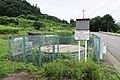
 Daido rain gauge station.jpg 5 472 × 3 648; 2,16 MB
-
 Emblem of Nakanojo, Gunma.svg 314 × 314; 650 byte
-
 Flag of Nakanojo Gunma.JPG 820 × 526; 24 KB
-
 Flag of Nakanojo, Gunma.svg 900 × 600; 508 byte
-
 Fuyusumi no Sato Museum.jpg 5 472 × 3 648; 1,87 MB
-
 Hanareyama poetry park.jpg 3 072 × 2 304; 1,15 MB
-

-

-

-
 Iriyama, Nakanojo, Agatsuma District, Gunma Prefecture 377-1701, Japan - panoramio.jpg 2 048 × 1 536; 507 KB
-
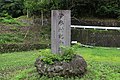 Isama village monument.jpg 5 472 × 3 648; 3,02 MB
-
 Japan National Route 405 in Iriyama,Nakanojo town,GUNMA.jpg 3 696 × 2 456; 7,89 MB
-
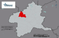 JP Gunma Nakanojo Town Location.png 1 066 × 688; 25 KB
-
 Junihara No. 12 drainage well.jpg 5 472 × 3 648; 3,48 MB
-
 Kuni Akaiwa Onsen Chouei no Kakureyu.jpg 5 472 × 3 648; 2,66 MB
-
 Kuni elementary school.jpg 5 472 × 3 648; 2,52 MB
-
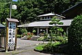
 Michinoeki reizan takeyama.jpg 1 280 × 960; 743 KB
-
 Naganohara-Oshi discontinued line.jpg 3 264 × 2 448; 1,64 MB
-
 Nakanojo Gardens.jpg 5 472 × 3 648; 2,33 MB
-
 Nakanojo Gunma chapter.JPG 362 × 369; 19 KB
-
 Nakanojo highschool.jpg 1 425 × 1 069; 257 KB
-
 Nakanojo in Gunma Prefecture Ja.svg 501 × 523; 11 KB
-
 Nakanojo post-office.jpg 1 555 × 1 166; 275 KB
-
 Nakanojo town Kuni branch office.jpg 5 472 × 3 648; 2,17 MB
-
 Nakanojo town Nakanojo elem-sch.jpg 1 425 × 1 069; 271 KB
-
 Nakanojo town-office.jpg 1 555 × 1 166; 216 KB
-
 Nozori Pass Rest House.jpg 4 000 × 2 250; 1,82 MB
-
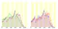 Population distribution of Nakanojo, Gunma, Japan.svg 512 × 256; 22 KB
-
 R145-2020-092.jpg 1 920 × 1 077; 431 KB
-
 R145-2020-102.jpg 1 920 × 1 078; 562 KB
-
 Shaberi-ishi.jpg 500 × 370; 54 KB
-
 Shibu-toge pass Nakanojo Gunma Japan 20130923 0538 photo by Pcs34560.jpg 5 472 × 3 648; 4,48 MB
-
 Toukee Ishi Volcanic rock.jpg 6 000 × 4 000; 12,54 MB
-
 Tsuchiya-Nakanojo-Gunma.JPG 1 024 × 768; 216 KB
-
 Yagura power station.jpg 2 112 × 2 816; 1,02 MB
-
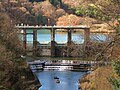 Yamadagawa Dam (Gunma).jpg 3 072 × 2 304; 964 KB
-
 つむじ 中之条伊勢町 2013 (9996398524).jpg 5 848 × 3 899; 5,02 MB
-
 ほづみとんかつ店 - panoramio.jpg 4 752 × 3 168; 1,75 MB
-
 中之条 (10000193603).jpg 6 000 × 4 000; 5,24 MB
-
 中之条 2013 (9992267035).jpg 6 000 × 4 000; 8,08 MB
-
 中之条 伊参エリア 2013 (10000112956).jpg 5 472 × 3 648; 10,85 MB
-
 中之条 六合エリア お蚕さんの里 2013 (10001348746).jpg 4 000 × 6 000; 5,76 MB
-
 中之条伊勢町エリア 2013 (9996538476).jpg 6 000 × 4 000; 7,73 MB
-
 地図-群馬県中之条町-2006.png 288 × 212; 6 KB
-
 堂内の木彫りの十王像.jpg 4 032 × 3 024; 3,21 MB
-
 東谷風穴(2号).jpg 4 032 × 3 024; 5,57 MB
-
 栃窪の全景.jpg 4 000 × 2 250; 4,11 MB
-
 栃窪の十王堂.jpg 4 032 × 3 024; 4,49 MB
-
 栃窪の十王堂にある石造物.jpg 4 032 × 3 024; 6,39 MB
-
 栃窪の如意輪観音像台銘.jpg 4 032 × 3 024; 4,48 MB
-
 栃窪の山神十二様石祠.jpg 4 032 × 3 024; 4,42 MB
-
 栃窪の東谷風穴.jpg 4 032 × 3 024; 4,88 MB
-
 栃窪分校の渡り廊下.jpg 4 032 × 3 024; 5,05 MB
-
 栃窪分校校舎.jpg 4 032 × 3 024; 5,34 MB
-
 栃窪地内の中村橋.jpg 4 032 × 3 024; 4,64 MB
-
 栃窪集落の全景.jpg 4 000 × 2 250; 4,08 MB
-
 横手山から南西の山々.jpg 8 189 × 1 855; 3,12 MB
-
 横手山から横手山から南東の山々.jpg 7 607 × 1 723; 2,88 MB
-
 群馬県中之条町大道 01.jpg 3 024 × 4 032; 5,68 MB
-
 群馬県中之条町大道 02.jpg 3 024 × 4 032; 4,8 MB
-
 群馬県中之条町大道 05.jpg 4 032 × 3 024; 4,82 MB
-
 群馬県中之条町大道 06.jpg 3 024 × 4 032; 3,52 MB
-
 群馬県中之条町大道 07.jpg 4 032 × 3 024; 5,05 MB
-
 群馬県中之条町大道 08.jpg 3 024 × 4 032; 3,45 MB
-
 群馬県中之条町大道 09.jpg 4 032 × 3 024; 5,21 MB
-
 群馬県中之条町大道 11.jpg 4 032 × 3 024; 5,53 MB
-
 群馬県吾妻郡中之条町.png 188 × 158; 11 KB
-
 近藤公園 中之条伊勢町エリア 2013 (9995896414).jpg 6 000 × 4 000; 13,11 MB
-
 近藤公園 中之条伊勢町エリア 2013 (9995937346).jpg 4 000 × 6 000; 12,28 MB


.jpg)
.jpg)
.jpg)


.jpg)
.jpg)

.jpg)
.jpg)
.jpg)
.jpg)
.jpg)


.jpg)
.jpg)