Category:Oberes Tor in Spalt
Jump to navigation
Jump to search
| Object location | | View all coordinates using: OpenStreetMap |
|---|
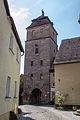
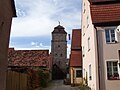
This is the category of the Bavarian Baudenkmal (cultural heritage monument) with the ID D-5-76-147-25 (Wikidata)
|
Deutsch: Oberes Tor, 1422 über mittelalterlichem Vorgängerbau errichtet, Mansarddachhelm 18. Jahrhundert; Reste des Vorwerks, wohl um 1422.
 | |||||
| Upload media | |||||
| Instance of | |||||
|---|---|---|---|---|---|
| Location | Spalt, Roth, Middle Franconia, Bavaria, Germany | ||||
| Street address |
| ||||
| Has part(s) |
| ||||
| Heritage designation | |||||
 | |||||
Media in category "Oberes Tor in Spalt"
The following 13 files are in this category, out of 13 total.
-
 D-5-76-147-25 01.jpg 3,137 × 4,980; 3.57 MB
-
 D-5-76-147-25 02.jpg 3,456 × 5,184; 2.95 MB
-
 Oberes Tor Spalt.jpg 3,960 × 2,970; 6.74 MB
-
 RHSpalt13.jpg 2,848 × 4,272; 2.18 MB
-
 Spalt-oberer-torturm.jpg 2,048 × 1,536; 778 KB
-
 Spalt Oberes Tor 8371.JPG 3,264 × 4,896; 8.97 MB
-
 Spalt, Stadtbefestigung, Oberes Tor, 001.jpg 3,264 × 4,928; 8.62 MB
-
 Spalt, Stadtbefestigung, Oberes Tor, 002.jpg 3,264 × 4,928; 8.26 MB
-
 Spalt, Stadtbefestigung, Oberes Tor, 003.jpg 3,264 × 4,928; 7.95 MB
-
 Spalt, Stadtbefestigung, Oberes Tor, 004.jpg 3,185 × 4,808; 7.27 MB
-
 Spalt, Stadtbefestigung, Oberes Tor, 005.jpg 4,928 × 3,264; 10.55 MB
-
 Spalt, Stadtbefestigung, Oberes Tor, 006.jpg 3,264 × 4,928; 9.22 MB
-
 Spalt, Stadtbefestigung, Turmgasse, Oberes Tor, 001.jpg 3,264 × 4,928; 8.38 MB


