Category:Ockley
Jump to navigation
Jump to search
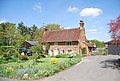
English: Ockley is a historic village in Surrey, built on Stane Street, a Roman Road stretching from Chichester to London. Situated between Dorking and Horsham, close to the Sussex/Surrey border, Ockley nestles in the shadows of Leith Hill, the highest point in South east England. Neighbouring villages include Capel, Ewhurst Green and Rusper. It is a linear settlement running along the A29 and lying about 3 km east of the A24. Ockley is also a civil parish covering .
village and civil parish in Mole Valley, Surrey, UK .JPG) L'église paroissiale est dédiée à sainte Marguerite | |||||
| Upload media | |||||
| Instance of | |||||
|---|---|---|---|---|---|
| Location | Mole Valley, Surrey, South East England, England | ||||
| Area |
| ||||
 | |||||
Subcategories
This category has the following 4 subcategories, out of 4 total.
J
- St John's Church, Ockley (7 F)
O
- Ockley railway station (11 F)
V
- Vann Lake and Ockley Woods (4 F)
Media in category "Ockley"
The following 200 files are in this category, out of 552 total.
(previous page) (next page)-
 2, Stane St - geograph.org.uk - 4171474.jpg 640 × 430; 103 KB
-
 A field of oats - geograph.org.uk - 1981515.jpg 640 × 428; 103 KB
-
 A29 at Henhurst Cross Lane - geograph.org.uk - 4451639.jpg 4,608 × 3,456; 6.14 MB
-
 A29 Stane Street approaching Ockley - geograph.org.uk - 2850229.jpg 4,000 × 3,000; 3.49 MB
-
 A29 Stane Street, Ockley - geograph.org.uk - 2928875.jpg 4,320 × 3,240; 3.96 MB
-
 A29 Stane Street, Ockley - geograph.org.uk - 2928892.jpg 4,320 × 3,240; 3.54 MB
-
 A29, Stane Street - geograph.org.uk - 4164826.jpg 640 × 430; 68 KB
-
 A29, Stane Street - geograph.org.uk - 4164897.jpg 640 × 430; 100 KB
-
 A29, Stane Street - geograph.org.uk - 4171422.jpg 640 × 430; 93 KB
-

-

-
 B2126 - geograph.org.uk - 4171738.jpg 640 × 430; 110 KB
-
 Barn by the Sussex Border Path - geograph.org.uk - 2845433.jpg 4,000 × 3,000; 3.51 MB
-
 Barn Conversions, Ockley Court - geograph.org.uk - 1811827.jpg 2,560 × 1,920; 1.78 MB
-
 Barn Cottage - geograph.org.uk - 461334.jpg 640 × 480; 54 KB
-
 Barn Cottage - geograph.org.uk - 461335.jpg 480 × 640; 76 KB
-
 Barn on Pear Tree Farm - geograph.org.uk - 253047.jpg 640 × 452; 306 KB
-
 Barn, Conversion, Ockley - geograph.org.uk - 4171750.jpg 640 × 430; 125 KB
-
 Barn, Conversion, Ockley - geograph.org.uk - 4171751.jpg 640 × 430; 82 KB
-
 Barn, Copsdale Farm - geograph.org.uk - 4127466.jpg 640 × 430; 120 KB
-
 Barn, Ockley Court - geograph.org.uk - 4174333.jpg 640 × 377; 78 KB
-
 Barns at Eversheds Farm - geograph.org.uk - 2850372.jpg 4,000 × 3,000; 3.62 MB
-
 Beare Green, Henhurst House - geograph.org.uk - 4383050.jpg 4,320 × 3,240; 5.38 MB
-
 Beare Green, Park Farm - geograph.org.uk - 4383087.jpg 4,608 × 3,456; 6.07 MB
-
 Beef on the hoof - geograph.org.uk - 4070417.jpg 640 × 430; 112 KB
-
 Bend on the road, bend in the river - geograph.org.uk - 2851740.jpg 4,000 × 3,000; 3.5 MB
-
 Birches Wood - geograph.org.uk - 189263.jpg 640 × 480; 178 KB
-
 Birches Wood - geograph.org.uk - 4157682.jpg 640 × 430; 161 KB
-
 Birches Wood - geograph.org.uk - 4157687.jpg 640 × 430; 155 KB
-
 Birches Wood - geograph.org.uk - 4157688.jpg 640 × 430; 144 KB
-
 Birches Wood - geograph.org.uk - 4157692.jpg 640 × 430; 154 KB
-
 Birches Wood - geograph.org.uk - 4157694.jpg 640 × 430; 160 KB
-
 Birches Wood - geograph.org.uk - 4157698.jpg 640 × 430; 162 KB
-
 Birches Wood - geograph.org.uk - 4157699.jpg 640 × 430; 145 KB
-
 Blue House on the Green - geograph.org.uk - 710208.jpg 640 × 480; 118 KB
-
 Bluebells, Candy's Copse - geograph.org.uk - 4157721.jpg 640 × 430; 167 KB
-
 Bluebells, Rowland Wood - geograph.org.uk - 4074104.jpg 640 × 430; 164 KB
-
 Boat Pond - geograph.org.uk - 2411765.jpg 1,920 × 2,560; 2.43 MB
-
 Bognor Road, Ockley - geograph.org.uk - 3390841.jpg 2,048 × 1,536; 1.48 MB
-
 Boswell's Farm (1) - geograph.org.uk - 4371667.jpg 1,024 × 770; 155 KB
-
 Boswell's Farm (2) - geograph.org.uk - 4377990.jpg 1,024 × 768; 189 KB
-
 Boswell's Farmhouse - geograph.org.uk - 957671.jpg 640 × 480; 61 KB
-
 Brick bridge over the North River - geograph.org.uk - 2851742.jpg 4,000 × 3,000; 3.49 MB
-
 Bridge on Jugshill Lane - geograph.org.uk - 1990341.jpg 640 × 428; 167 KB
-
 Bridge Out - geograph.org.uk - 156042.jpg 593 × 640; 189 KB
-
 Bridge over Weare Street Gill - geograph.org.uk - 1981532.jpg 640 × 428; 199 KB
-
 Bridges^ in Birches Wood - geograph.org.uk - 2850329.jpg 4,000 × 3,000; 3.53 MB
-
 Bridleway ascends from Weare Street Gill - geograph.org.uk - 5330532.jpg 800 × 600; 230 KB
-

-
 Bridleway bends at bridge - geograph.org.uk - 5351388.jpg 800 × 600; 196 KB
-

-
 Bridleway crossing a field - geograph.org.uk - 4151234.jpg 640 × 430; 73 KB
-

-
 Bridleway gate and bridge - geograph.org.uk - 2850095.jpg 4,000 × 3,000; 3.37 MB
-
 Bridleway junction, Birches Wood - geograph.org.uk - 4157676.jpg 640 × 430; 151 KB
-
 Bridleway Junction, Candy's Copse - geograph.org.uk - 4157745.jpg 640 × 430; 142 KB
-
 Bridleway near Vann House - geograph.org.uk - 4157817.jpg 640 × 430; 134 KB
-
 Bridleway off Cole's Lane - geograph.org.uk - 4179351.jpg 640 × 430; 144 KB
-
 Bridleway to Vann House - geograph.org.uk - 4164742.jpg 640 × 430; 131 KB
-
 Bridleway to Weare St - geograph.org.uk - 4151254.jpg 640 × 430; 106 KB
-
 Bridleway, Birches Wood - geograph.org.uk - 4157667.jpg 640 × 430; 157 KB
-
 Bridleway, Birches Wood - geograph.org.uk - 4157686.jpg 640 × 430; 155 KB
-
 Bridleway, Birches Wood - geograph.org.uk - 4157696.jpg 640 × 430; 150 KB
-
 Bridleway, Birches Wood - geograph.org.uk - 4157697.jpg 640 × 430; 150 KB
-
 Bridleway, Birches Wood - geograph.org.uk - 4157704.jpg 640 × 430; 147 KB
-
 Bridleway, Candy's Copse - geograph.org.uk - 4157717.jpg 640 × 430; 149 KB
-
 Bridleway, Candy's Copse - geograph.org.uk - 4157730.jpg 640 × 430; 152 KB
-
 Bridleway, Candy's Copse - geograph.org.uk - 4157735.jpg 640 × 430; 154 KB
-
 Bridleway, Holbrook Farm - geograph.org.uk - 4151227.jpg 640 × 430; 110 KB
-
 Bridleway, Holbrook Farm - geograph.org.uk - 4151232.jpg 640 × 430; 104 KB
-
 Broomehall Road in January - geograph.org.uk - 3311758.jpg 1,024 × 768; 215 KB
-
 Broomehall Road, Ockley - geograph.org.uk - 4818619.jpg 2,048 × 1,536; 1.5 MB
-
 Broomehall Road, Ockley - geograph.org.uk - 4823619.jpg 2,048 × 1,536; 786 KB
-
 Broomehall Road, Ockley - geograph.org.uk - 4823620.jpg 2,048 × 1,536; 1.08 MB
-
 Buckinghill Farm - geograph.org.uk - 2277932.jpg 2,560 × 1,920; 1.7 MB
-
 Buckinghill Farm House - geograph.org.uk - 5772964.jpg 662 × 1,000; 864 KB
-
 Buckinghill Farm House - geograph.org.uk - 5772965.jpg 1,000 × 662; 923 KB
-
 Building work at Vann Farm - geograph.org.uk - 2848680.jpg 4,000 × 3,000; 3.48 MB
-
 Buttercup meadow - geograph.org.uk - 4127672.jpg 640 × 430; 91 KB
-
 Buttercup meadow - geograph.org.uk - 4127679.jpg 640 × 430; 92 KB
-
 Buttercup meadow - geograph.org.uk - 4142947.jpg 640 × 430; 97 KB
-
 Candy's Copse - geograph.org.uk - 4157714.jpg 640 × 430; 154 KB
-
 Candy's Copse - geograph.org.uk - 4157723.jpg 640 × 430; 151 KB
-
 Candy's Copse - geograph.org.uk - 4157724.jpg 640 × 430; 160 KB
-
 Cathill Lane at the junction of Stane Street - geograph.org.uk - 4818286.jpg 2,048 × 1,536; 1.53 MB
-
 Cathill Lane passing over Standon Gill - geograph.org.uk - 2850187.jpg 4,000 × 3,000; 3.37 MB
-
 Clump of trees - geograph.org.uk - 4127661.jpg 640 × 430; 82 KB
-
 Coach House, Ockley Station - geograph.org.uk - 4179632.jpg 640 × 430; 58 KB
-
 Cole's Lane - geograph.org.uk - 4179346.jpg 640 × 430; 93 KB
-
 Cole's Lane - geograph.org.uk - 4179347.jpg 640 × 430; 115 KB
-
 Cole's Lane - geograph.org.uk - 4179350.jpg 640 × 430; 121 KB
-
 Cole's Lane - geograph.org.uk - 4179605.jpg 640 × 430; 122 KB
-
 Cole's Lane - geograph.org.uk - 4179608.jpg 640 × 430; 93 KB
-
 Cole's Lane - geograph.org.uk - 4179612.jpg 640 × 430; 89 KB
-
 Cole's Lane - geograph.org.uk - 4179616.jpg 640 × 430; 110 KB
-
 Cole's Lane - geograph.org.uk - 4179620.jpg 640 × 430; 111 KB
-
 Coles Lane - geograph.org.uk - 4171739.jpg 640 × 430; 102 KB
-
 Coles Lane at the junction of Stane Street - geograph.org.uk - 4818698.jpg 2,048 × 1,536; 1.5 MB
-
 Coles Lane, B2126 - geograph.org.uk - 4171743.jpg 640 × 430; 109 KB
-
 Combined workshop and housing on Vann Lake Road - geograph.org.uk - 2847116.jpg 4,000 × 3,000; 3.15 MB
-
 Coppicing, Birches Wood - geograph.org.uk - 4157675.jpg 640 × 430; 144 KB
-
 Copsdale Farm - geograph.org.uk - 4127459.jpg 640 × 430; 145 KB
-
 Cottage Industry - geograph.org.uk - 1811787.jpg 2,560 × 1,920; 1.83 MB
-
 Cottage on Weare Street - geograph.org.uk - 4127470.jpg 640 × 430; 118 KB
-
 Cottage on Weare Street - geograph.org.uk - 4127472.jpg 640 × 430; 89 KB
-
 Cottage, Ockley - geograph.org.uk - 710201.jpg 640 × 480; 99 KB
-

-
 Cottages at Stylehurst - geograph.org.uk - 147825.jpg 640 × 480; 129 KB
-
 Cottages on Ockley Green - geograph.org.uk - 2848741.jpg 4,000 × 3,000; 3.36 MB
-
 Cottages on Weare Street - geograph.org.uk - 4824105.jpg 800 × 600; 134 KB
-
 Cottages, Ockley Court - geograph.org.uk - 4174340.jpg 640 × 399; 64 KB
-
 Country Industrial Estate - geograph.org.uk - 2411823.jpg 2,560 × 1,920; 2.23 MB
-
 Countryside near Ockley - geograph.org.uk - 4171740.jpg 640 × 385; 51 KB
-
 Countryside near Ockley Court - geograph.org.uk - 4171742.jpg 640 × 430; 70 KB
-
 Courtbottom Wood - geograph.org.uk - 4171744.jpg 640 × 430; 75 KB
-
 Cows near Netter's Hall, Attwaters Lane - geograph.org.uk - 332759.jpg 640 × 480; 161 KB
-
 Crossing a field - geograph.org.uk - 4151251.jpg 640 × 430; 90 KB
-
 Crossing just north of Ockley Station - geograph.org.uk - 4179826.jpg 640 × 430; 116 KB
-
 Daffodils on path to Tiphams - geograph.org.uk - 2847009.jpg 4,000 × 3,000; 3.44 MB
-
 Damaged spillway from Vann Lake - geograph.org.uk - 2848658.jpg 4,000 × 3,000; 3.47 MB
-
 Dead and alive - geograph.org.uk - 2850377.jpg 4,000 × 3,000; 3.46 MB
-
 Development on Stane Street - geograph.org.uk - 5351366.jpg 800 × 685; 139 KB
-
 Dovecote at Holbrook Farm - geograph.org.uk - 2846982.jpg 4,000 × 3,000; 3.31 MB
-
 Driveway on Stane Street, Ockley - geograph.org.uk - 4818703.jpg 2,048 × 1,536; 1.5 MB
-
 Duck house on pond by Weare Street - geograph.org.uk - 2847021.jpg 4,000 × 3,000; 3.27 MB
-
 Ducks and geese on roadside pond - geograph.org.uk - 2847017.jpg 4,000 × 3,000; 3.46 MB
-
 Dugshill Copse - geograph.org.uk - 4070454.jpg 640 × 430; 145 KB
-

-
 Dwellings on Stane Street - geograph.org.uk - 5351365.jpg 800 × 600; 92 KB
-
 Edge of Timber Gill - geograph.org.uk - 4151205.jpg 640 × 430; 74 KB
-
 Edge of Timber Gill - geograph.org.uk - 4151206.jpg 640 × 430; 88 KB
-
 Elmer's Mill, Ockley - geograph.org.uk - 1981495.jpg 640 × 428; 91 KB
-
 Elmers Close, Ockley - geograph.org.uk - 4818477.jpg 2,048 × 1,536; 1.5 MB
-
 Elmers Close. Ockley - geograph.org.uk - 4823615.jpg 2,048 × 1,536; 1.53 MB
-
 Elmers Mill from the east, October 2013 - geograph.org.uk - 3715477.jpg 1,024 × 795; 156 KB
-
 Elmers Mill rebuild well underway - geograph.org.uk - 1221122.jpg 640 × 480; 96 KB
-
 Elmers Mill Ruin - geograph.org.uk - 535493.jpg 640 × 480; 59 KB
-
 End of a hedge - geograph.org.uk - 4151208.jpg 640 × 430; 75 KB
-
 Enderslie Farm - geograph.org.uk - 4164810.jpg 640 × 430; 115 KB
-
 Enderslie Farm - geograph.org.uk - 4164813.jpg 640 × 430; 88 KB
-
 Entrance to Knoll Farm - geograph.org.uk - 2847044.jpg 4,000 × 3,000; 3.48 MB
-
 Entrance to Midways on Weare Street - geograph.org.uk - 5330511.jpg 1,024 × 768; 289 KB
-
 Entrance to Smuggler's Lane - geograph.org.uk - 189270.jpg 640 × 480; 176 KB
-
 Eversheds Farm - geograph.org.uk - 1981508.jpg 640 × 428; 101 KB
-
 Farm on Ockley Road, Forest Green - geograph.org.uk - 3390852.jpg 2,048 × 1,536; 1.53 MB
-
 Farm track leading to Parkland Farmhouse - geograph.org.uk - 2850115.jpg 4,000 × 3,000; 3.67 MB
-
 Farmland by the Sussex Border Path - geograph.org.uk - 4070445.jpg 640 × 430; 80 KB
-
 Farms near Winterfold - geograph.org.uk - 5151941.jpg 1,519 × 965; 424 KB
-
 Field above Vann Lake - geograph.org.uk - 4157815.jpg 640 × 430; 59 KB
-
 Field by Henhurst Furze - geograph.org.uk - 2278805.jpg 2,560 × 1,920; 1.7 MB
-
 Field by Ockley Road - geograph.org.uk - 3391491.jpg 2,048 × 1,536; 1.55 MB
-
 Field south of Oakdale Farm - geograph.org.uk - 4127656.jpg 640 × 430; 71 KB
-
 Field south of Oakdale Farm - geograph.org.uk - 4127663.jpg 640 × 430; 70 KB
-
 Flowering trees by Stane Street - geograph.org.uk - 4164911.jpg 640 × 430; 108 KB
-
 Footbridge - geograph.org.uk - 4127631.jpg 640 × 430; 143 KB
-
 Footbridge across Street Gill - geograph.org.uk - 4157657.jpg 640 × 430; 141 KB
-
 Footbridge at Boat Pond - geograph.org.uk - 2411772.jpg 2,560 × 1,920; 2.28 MB
-
 Footbridge in the Woods - geograph.org.uk - 189275.jpg 640 × 480; 183 KB
-
 Footbridge over Letts Gill - geograph.org.uk - 4824067.jpg 800 × 600; 187 KB
-
 Footbridge over stream at path junction - geograph.org.uk - 5351384.jpg 800 × 600; 249 KB
-
 Footbridge, Wattlehurst Gill - geograph.org.uk - 4151197.jpg 640 × 430; 138 KB
-
 Footpath 170 to Birches Wood - geograph.org.uk - 2850256.jpg 4,000 × 3,000; 3.58 MB
-
 Footpath along field edge - geograph.org.uk - 4127666.jpg 640 × 430; 104 KB
-
 Footpath and driveway to Buckinghill Farm - geograph.org.uk - 3596609.jpg 3,264 × 2,448; 4.88 MB
-
 Footpath by Great Copse - geograph.org.uk - 2278779.jpg 2,560 × 1,920; 1.65 MB
-
 Footpath by Henhurst Furze - geograph.org.uk - 2278784.jpg 1,920 × 2,560; 1.76 MB
-
 Footpath Near Bearhurst - geograph.org.uk - 2278811.jpg 2,560 × 1,920; 1.35 MB
-
 Footpath off Cole's Lane - geograph.org.uk - 4179629.jpg 640 × 430; 106 KB
-
 Footpath off Coles Lane - geograph.org.uk - 4171741.jpg 640 × 430; 92 KB
-

-
 Footpath to Eversheds Farm - geograph.org.uk - 2850370.jpg 4,000 × 3,000; 3.56 MB
-
 Footpath to Holbrook Farm - geograph.org.uk - 4151213.jpg 640 × 430; 81 KB
-
 Footpath with dwelling off Stane Street - geograph.org.uk - 5351367.jpg 800 × 600; 159 KB
-
 Footpath, Bridleway junction - geograph.org.uk - 4157806.jpg 640 × 430; 157 KB
-
 Footpath, Bridleway junction - geograph.org.uk - 4157809.jpg 640 × 430; 151 KB
-
 Footpath, Timber Gill - geograph.org.uk - 4151199.jpg 640 × 430; 156 KB
-
 Footpath, Timber Gill - geograph.org.uk - 4151200.jpg 640 × 430; 135 KB
-
 Forge Cottages - geograph.org.uk - 4171411.jpg 640 × 430; 89 KB
-
 Fountain at Henhurst House - geograph.org.uk - 4451644.jpg 4,608 × 3,456; 6.11 MB
-
 Friday St - geograph.org.uk - 4164766.jpg 640 × 430; 112 KB
-
 Friday St - geograph.org.uk - 4164777.jpg 640 × 430; 129 KB
-
 Friday Street - geograph.org.uk - 4164790.jpg 640 × 430; 132 KB
-
 Friday Street - geograph.org.uk - 4164799.jpg 640 × 430; 109 KB
-
 Friday Street - geograph.org.uk - 4164807.jpg 640 × 430; 133 KB
-
 Friday Street - geograph.org.uk - 4164816.jpg 640 × 430; 135 KB
-
 Fridays - geograph.org.uk - 4164763.jpg 640 × 430; 92 KB
-
 Galleted stonework, Ockley church (2) - geograph.org.uk - 4387733.jpg 768 × 1,024; 300 KB
-
 Galleted stonework, Ockley church - geograph.org.uk - 4387731.jpg 768 × 1,024; 304 KB
-
 Gate piers, Ockley - geograph.org.uk - 4417661.jpg 640 × 487; 186 KB
-
 Gateway to Vann House - geograph.org.uk - 4164749.jpg 640 × 430; 83 KB
-
 Grassland - geograph.org.uk - 4151253.jpg 640 × 430; 75 KB
-
 Grassy field - geograph.org.uk - 4151237.jpg 640 × 430; 84 KB
-
 Greenhouse, Cole's Lane - geograph.org.uk - 4179341.jpg 640 × 430; 64 KB
-
 Greenhouses, Cole's Lane - geograph.org.uk - 4179343.jpg 640 × 369; 62 KB
-
 Hatch Cottage - geograph.org.uk - 4171484.jpg 640 × 430; 80 KB
-
 Hatch Cottages - geograph.org.uk - 4171491.jpg 640 × 399; 73 KB
-
 Heathfield Cottages, Ockley - geograph.org.uk - 1153879.jpg 640 × 427; 104 KB
-
 Heathland, Frensham Great Pond - geograph.org.uk - 1384617.jpg 640 × 480; 123 KB
-
 Heathland, Frensham Little Pond - geograph.org.uk - 1384636.jpg 640 × 480; 68 KB
-
 Hedgerow and footpath to Holbrook Farm - geograph.org.uk - 2846977.jpg 4,000 × 3,000; 3.53 MB


_-_geograph.org.uk_-_4371667.jpg)
_-_geograph.org.uk_-_4377990.jpg)


_-_geograph.org.uk_-_4387733.jpg)


