Category:Panský dvůr (Jiříkovice)
Jump to navigation
Jump to search
| Object location | | View all coordinates using: OpenStreetMap |
|---|
cultural monument of the Czech Republic in Jiříkovice .jpg) | |||||
| Upload media | |||||
| Instance of | |||||
|---|---|---|---|---|---|
| Located in protected area |
| ||||
| Location | Jiříkovice, Q12425479, Brno-Country District, South Moravian Region, Czechia | ||||
| Conscription number |
| ||||
| Located on street |
| ||||
| Heritage designation | |||||
 | |||||
|
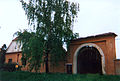
This is a category about a cultural monument of the Czech Republic,
number: 11577/7-8726. |
Media in category "Panský dvůr (Jiříkovice)"
The following 19 files are in this category, out of 19 total.
-
 Jiříkovice, Blažovská, panský dvůr (0606a).jpg 3,888 × 2,592; 7.06 MB
-
 Jiříkovice, Blažovská, panský dvůr (5303).jpg 3,888 × 2,592; 3.58 MB
-
 Jiříkovice, Blažovská, panský dvůr a prodejna (5304b).jpg 3,594 × 2,396; 3.85 MB
-
 Jiříkovice, Na Návsi, naučná stezka (0132ba).jpg 3,715 × 2,475; 6.58 MB
-
 Jiříkovice, Na Návsi, naučná stezka (0614ba).jpg 2,488 × 3,731; 5.59 MB
-
 Jiříkovice, Na Návsi, panský dvůr (0137a).jpg 3,888 × 2,592; 5.26 MB
-
 Jiříkovice, Na Návsi, panský dvůr (0143c).jpg 3,888 × 2,592; 5.08 MB
-
 Jiříkovice, Na Návsi, panský dvůr (0612a).jpg 3,888 × 2,592; 7.34 MB
-
 Jiříkovice, Na Návsi, panský dvůr (0613a).jpg 3,888 × 2,592; 6.23 MB
-
 Jiříkovice, Na Návsi, panský dvůr (0615a).jpg 3,888 × 2,592; 6.86 MB
-
 Jiříkovice, Na Návsi, panský dvůr (0616a).jpg 3,888 × 2,592; 5.82 MB
-
 Jiříkovice, Na Návsi, panský dvůr (0622a).jpg 3,888 × 2,592; 6.81 MB
-
 Jiříkovice, Na Návsi, panský dvůr (0651ac).jpg 3,888 × 2,592; 6.32 MB
-
 Jiříkovice, Na Návsi, panský dvůr (img 0623a).jpg 2,592 × 3,888; 7.2 MB
-
 Jiříkovice, Na Návsi, zvonice (5298cca).jpg 3,888 × 2,592; 4.43 MB
-
 Statek na návsi, Jiříkovice 1.jpg 3,888 × 2,592; 3.81 MB
-
 Statek na návsi, Jiříkovice 1995.jpg 3,054 × 2,064; 1.45 MB
-
 Statek na návsi, Jiříkovice 2.jpg 3,888 × 2,592; 5.21 MB
-
 Statek na návsi, Jiříkovice 3.jpg 3,888 × 2,592; 4.91 MB
.jpg)
.jpg)
.jpg)
.jpg)
.jpg)
.jpg)
.jpg)
.jpg)
.jpg)
.jpg)
.jpg)
.jpg)
.jpg)
.jpg)


