Category:Perach
Jump to navigation
Jump to search
municipality of Germany  Biserica   | |||||
| Upload media | |||||
| Instance of |
| ||||
|---|---|---|---|---|---|
| Part of |
| ||||
| Location | Altötting, Upper Bavaria, Bavaria, Germany | ||||
| Located in or next to body of water | |||||
| Head of government |
| ||||
| Population |
| ||||
| Area |
| ||||
| Elevation above sea level |
| ||||
| Different from | |||||
| official website | |||||
 | |||||
Subcategories
This category has the following 3 subcategories, out of 3 total.
Media in category "Perach"
The following 7 files are in this category, out of 7 total.
-
 Abschnittsbefestigung Schmidhub.PNG 563 × 412; 525 KB
-
 Bahnhof Perach 2020.jpg 4,332 × 2,916; 8.82 MB
-
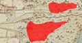 Burgstall bei Weingarten und Burg Tachenberg.PNG 740 × 395; 659 KB
-
 DEU Perach COA.svg 512 × 559; 33 KB
-
 Karte perach in aoe.gif 284 × 295; 4 KB
-
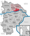 Perach in AÖ.svg 409 × 491; 306 KB
-
 Wappen perach.png 692 × 800; 31 KB


